Airports for X-Plane offers a convenient way to explore airports and their related communication information for the X-Plane flight simulator. It only uses data from the X-Plane flight simulator itself, and is therefore more reliable than the data that comes from real aviation websites. You can search for airports by using the ICAO code, or browse for airports per country and state. The information displayed is categorized by airport details, runway information, airport communication, approach frequencies (ILS and Glidepath details), details of nearby beacons, SIDs, STARs and approach procedures.

asphalt airport apron jet aircraft carrier embassy airliner aviation rail transport seaplanes taxi buildings regional landing government air terminal corporation immigration helicopters airport terminal airport

Wiener Neustadt - Wr Neustadt West

Airport details

CountryAustria
StateLower Austria
RegionLO
AirspaceVienna Ctr
MunicipalityWiener Neustadt
Elevation830ft (253m)
TimezoneGMT +1
Coordinates47.83972, 16.22028
Magnetic var
Typeland
Available sinceX-Plane v10.40
ICAO codeLOXN
IATA coden/a
FAA coden/a

Communication

Wr Neustadt West Tower130.150
Nearby Points of Interest:
Fliegerkaserne Wiener Neustadt
-
Dr.-Karl-Renner-Hof
-
Israelitischer Friedhof Wiener Neustadt
-
Maximilian-Kaserne
-
Spinnerin am Kreuz (Wiener Neustadt)
-
Landesberufsschule
-
Wiener Neustädter Lokomotivfabrik
-
Schule am Baumkirchnerring
-
Schule Santa Christiana Wiener Neustadt
-
Stadtarchiv Wiener Neustadt
-
Dompropstei Wiener Neustadt
-
Pestalozzischule Wiener Neustadt
-
Rabenturm
-
Karmeliterkirche
-
Hauptplatz 20, Wiener Neustadt
-
Lederergasse 8
-
Kasematten Wiener Neustadt
-
Capuchin Church, Wiener Neustadt
-
Marienheim Wiener Neustadt
-
Teile der Stadtbefestigung
-
Stubenberger Turm
-
Deutschordenskommende Wiener Neustadt
-
Landesgericht Wiener Neustadt
-
Neunkirchner Straße 36 (Wiener Neustadt)
-
St. George's Cathedral, Wiener Neustadt

Runway info

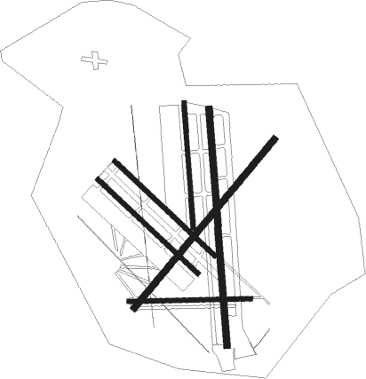
Runway 09 / 27  
 length838m (2749ft)
 bearing92° / 272°
 width30m (98ft)
 surfacegrass
Runway 04 / 22  
 length1503m (4931ft)
 bearing55° / 235°
 width45m (148ft)
 surfacegrass
Runway 18L / 36R  
 length1626m (5335ft)
 bearing180° / 0°
 width45m (148ft)
 surfacegrass
Runway 18R / 36L  
 length864m (2835ft)
 bearing180° / 0°
 width30m (98ft)
 surfacegrass
Runway 14L / 32R  
 length942m (3091ft)
 bearing127° / 307°
 width30m (98ft)
 surfacegrass
Runway 14R / 32L  
 length941m (3087ft)
 bearing127° / 307°
 width30m (98ft)
 surfacegrass

Airport layout


Nearby beacons

codeidentifierdistbearingfrequency
SNUSOLLENAU VOR/DME3.463°115.50
STESTEINHOF NDB22.3293
FMDFISCHAMEND VOR/DME22.957°110.40
BRKBRUCK NDB2466°408
TUNTULLN NDB29.7333°358
TUNTULLN VOR/DME29.8333°111.40
WGMWAGRAM VOR/DME3129°112.20
STOSTOCKERAU VOR/DME35.6341°113
RAWDME38219°112.15
GBGGLEICHENBERG NDB59.7204°426
STKKOGEL DME60.8196°114.55
GRZGRAZ VOR/DME61.6221°116.20
GRZGRAZ NDB63.2220°290

Disclaimer

The information on this website is not for real aviation. Use this data with the X-Plane flight simulator only! Data taken with kind consent from X-Plane 12 source code and data files. Content is subject to change without notice.