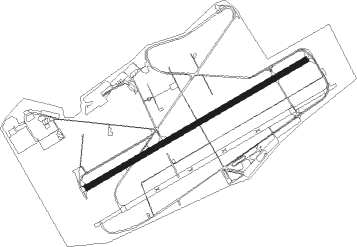
Buochs
Airport details
| Country | Switzerland |
| State | Nidwalden |
| Region | LS |
| Airspace | Switzerland Ctr |
| Municipality | Buochs |
| Elevation | 1472ft (449m) |
| Timezone | GMT +1 |
| Coordinates | 46.97134, 8.39987 |
| Magnetic var | |
| Type | land |
| Available since | X-Plane v10.40 |
| ICAO code | LSZC |
| IATA code | BXO |
| FAA code | n/a |
Communication
| Buochs FIS | 124.700 |
| Buochs AIR TO AIR | 134.125 |
| Buochs Tower | 119.625 |
| Buochs Emmen ARR | 120.425 |
| Buochs Alpnach ARR | 128.475 |
Nearby Points of Interest:
Fadenbrücke
-Stans
-Stanserhorn-Bahn
-Steigelfadbalm
-Pilatus railway
-Schweizer Schachmuseum
-Schiller
-Gallia
-Uri (ship, 1901)
-Stadt Luzern
-Unterwalden
-Kloster St. Anna
-Lucerne Central and University Library
-Gotthardgebäude
-Reussbrücke
-Lucerne
-Staatsarchiv Luzern
-Anderallmend-Haus
-Friedhof Friedental
-Arth
-Former barracks Sarnen
-Sarnen
-cantonal library Obwalden
-Doppelhaus Grundacher, Sarnen
-Kloster St. Andreas, Sarnen
Nearby beacons
| code | identifier | dist | bearing | frequency |
|---|---|---|---|---|
| WIL | WILLISAU VOR/DME | 23.7 | 293° | 116.90 |
| KLO | KLOTEN (ZURICH) VOR/DME | 29.7 | 17° | 114.85 |
| ZUE | ZURICH EAST VOR/DME | 40.9 | 34° | 110.05 |
| GRE | GRENCHEN VOR/DME | 42.1 | 282° | 115.45 |
| HOC | DME | 42.2 | 304° | 113.20 |
| TRA | DME | 43.1 | 3° | 114.30 |
| BS | BASLE-MULHOUSE NDB | 50.7 | 305° | 376 |
| BLM | BASLE-MULHOUSE VOR/DME | 54 | 306° | 117.45 |
| BN | BASLE-MULHOUSE NDB | 55.8 | 307° | 353 |
Departure and arrival routes
| Transition altitude | 7000ft |
| SID end points | distance | outbound heading | |
|---|---|---|---|
| RW24 | |||
| WIL3A | 24mi | 293° | |
| STAR starting points | distance | inbound heading | |
|---|---|---|---|
| ALL | |||
| WIL2F | 23.7 | 113° | |
| ASGE1F | 17.3 | 213° | |
Instrument approach procedures
| runway | airway (heading) | route (dist, bearing) |
|---|---|---|
| RWNVA | RONIX (193°) | RONIX 6000ft ZC700 (4mi, 120°) ZC701 (2mi, 184°) 4500ft KUSIX (3mi, 229°) 4500ft |
| RNAV | KUSIX 4500ft ZC760 (6mi, 229°) 2280ft ZC752 (12mi, 290°) ZC753 (6mi, 51°) RONIX (9mi, 86°) 6000ft RONIX (turn) |
Holding patterns
| STAR name | hold at | type | turn | heading* | altitude | leg | speed limit |
|---|---|---|---|---|---|---|---|
| ASGE1F | RONIX | VHF | left | 36 (216)° | 7000ft - 9000ft | 1.0min timed | 180 |
| WIL2F | RONIX | VHF | left | 36 (216)° | 7000ft - 9000ft | 1.0min timed | 180 |
| *) magnetic outbound (inbound) holding course | |||||||
Disclaimer
The information on this website is not for real aviation. Use this data with the X-Plane flight simulator only! Data taken with kind consent from X-Plane 12 source code and data files. Content is subject to change without notice.