İzmir - Adnan Menderes
Airport details
| Country | Turkey |
| State | İzmir Province |
| Region | LT |
| Airspace | Istanbul Ctr |
| Municipality | Menderes |
| Elevation | 423ft (129m) |
| Timezone | GMT +3 |
| Coordinates | 38.27411, 27.16378 |
| Magnetic var | |
| Type | land |
| Available since | X-Plane v10.30 |
| ICAO code | LTBJ |
| IATA code | ADB |
| FAA code | n/a |
Communication
| Adnan Menderes ATIS | 129.200 |
| Adnan Menderes Ground Control | 121.900 |
| Adnan Menderes Ground Control | 121.700 |
| Adnan Menderes Tower | 118.100 |
| Adnan Menderes Approach | 119.450 |
| Adnan Menderes Approach | 120.100 |
| Adnan Menderes Approach | 120.175 |
| Adnan Menderes Approach | 134.200 |
| Adnan Menderes Departure | 118.100 |
Approach frequencies
| ILS-cat-II | RW34R | 110.3 | 18.00mi |
| ILS-cat-I | RW16L | 108.5 | 18.00mi |
| 3.1° GS | RW16L | 108.5 | 18.00mi |
| 3° GS | RW34R | 110.3 | 18.00mi |
Nearby Points of Interest:
Gediz Delta
-Foça
Runway info
Runway 16L / 34R  | ||
| length | 3244m (10643ft) | |
| bearing | 163° / 343° | |
| width | 45m (148ft) | |
| surface | asphalt | |
| blast zone | 61m (200ft) / 63m (207ft) | |
| Runway 16R / 34L | ||
| length | 3247m (10653ft) | |
| bearing | 163° / 343° | |
| width | 43m (141ft) | |
| surface | concrete | |
| blast zone | 60m (197ft) / 60m (197ft) | |
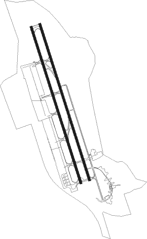
Airport layout
Taxiway locations
Parking locations
Nearby beacons
| code | identifier | dist | bearing | frequency |
|---|---|---|---|---|
| EN | ADNAN MENDERES (IZMIR) NDB | 0.2 | 179° | 315 |
| MEN | MENDERES (IZMIR) VOR/DME | 1.2 | 347° | 117.90 |
| ME | ADNAN MENDERES (IZMIR) NDB | 4.7 | 164° | 405 |
| IMR | IZMIR VOR/DME | 7.8 | 285° | 113.70 |
| CIG | CIGLI (IZMIR) TACAN | 15.1 | 325° | 113.60 |
| CIG | CIGLI (IZMIR) NDB | 16.5 | 330° | 363 |
| KLC | KAKLIC TACAN | 17.2 | 323° | 114.15 |
| SEL | SELCUK-EFES NDB | 21.1 | 152° | 424 |
| SMO | SAMOS NDB | 37.2 | 203° | 375 |
| SAM | SAMOS VOR/DME | 37.3 | 204° | 111.60 |
| CLD | CILDIR (AYDIN) NDB | 43.8 | 122° | 480 |
| CLD | CILDIR (AYDIN) VOR/DME | 44.2 | 122° | 113.85 |
| AKI | AKHISAR TACAN | 45.2 | 51° | 110.20 |
| IKA | IKARIA NDB | 52.5 | 234° | 322 |
| LVO | MITILINI NDB | 53.4 | 324° | 397 |
| MLN | MITILINI VOR/DME | 53.9 | 324° | 109.60 |
| LSV | LESVOS VOR/DME | 67 | 322° | 114.20 |
Departure and arrival routes
| Transition altitude | 10000ft |
| SID end points | distance | outbound heading | |
|---|---|---|---|
| RW16 (ALL) | |||
| VAKU1S | 53mi | 78° | |
| BAPS1S, BAPS1K | 39mi | 110° | |
| SISV1S, SISV1K | 37mi | 122° | |
| OKES1K, OKES1S | 40mi | 161° | |
| REDR1K, REDR1S | 35mi | 245° | |
| SITR1K, SITR1S | 42mi | 259° | |
| VEXO1K, VEXO1S | 45mi | 274° | |
| RIKS1S, RIKS1K | 48mi | 307° | |
| BERG1S | 44mi | 358° | |
| RW34 (ALL) | |||
| VAKU1G, VAKU1E | 53mi | 78° | |
| BAPS1E, BAPS1F, BAPS1G | 39mi | 110° | |
| SISV1E, SISV1G, SISV1F | 37mi | 122° | |
| OKES1G, OKES1E | 40mi | 161° | |
| REDR1E, REDR1G | 35mi | 245° | |
| SITR1G, SITR1E | 42mi | 259° | |
| VEXO1G, VEXO1E | 45mi | 274° | |
| RIKS1G, RIKS1E | 48mi | 307° | |
| BERG1G, BERG1E | 44mi | 358° | |
| STAR starting points | distance | inbound heading | |
|---|---|---|---|
| ALL | |||
| REDR1C | 34.9 | 65° | |
| SITR1C | 42.0 | 79° | |
| VEXO1C | 45.4 | 94° | |
| RIKS1C | 48.0 | 127° | |
| BERG1C | 43.5 | 178° | |
| VAKU1C | 71.5 | 258° | |
| BAPS1C | 38.6 | 290° | |
| SISV1C | 36.8 | 302° | |
| OKES1C | 40.1 | 341° | |
Holding patterns
| STAR name | hold at | type | turn | heading* | altitude | leg | speed limit |
|---|---|---|---|---|---|---|---|
| OKES1C | AYDIN | VHF | left | 153 (333)° | 8000ft - 13000ft | 1.0min timed | ICAO rules |
| VEXO1C | MENGU | VHF | right | 270 (90)° | 8000ft - 13000ft | 1.0min timed | ICAO rules |
| *) magnetic outbound (inbound) holding course | |||||||
Disclaimer
The information on this website is not for real aviation. Use this data with the X-Plane flight simulator only! Data taken with kind consent from X-Plane 12 source code and data files. Content is subject to change without notice.