Bratislava - Bratislava/m.r.Štefánik
Airport details
| Country | Slovakia |
| State | Region of Bratislava |
| Region | LZ |
| Airspace | Bratislava Ctr |
| Municipality | Bratislava |
| Elevation | 436ft (133m) |
| Timezone | GMT +1 |
| Coordinates | 48.16948, 17.20564 |
| Magnetic var | |
| Type | land |
| Available since | X-Plane v10.32 |
| ICAO code | LZIB |
| IATA code | BTS |
| FAA code | n/a |
Communication
| Bratislava/M.R.Štefánik ŠTEFÁNIK ATIS ARRIVAL | 133.880 |
| Bratislava/M.R.Štefánik ŠTEFÁNIK ATIS DepartureARTURE | 128.655 |
| Bratislava/M.R.Štefánik ŠTEFÁNIK GROUND | 120.905 |
| Bratislava/M.R.Štefánik ŠTEFÁNIK TOWER | 118.300 |
| Bratislava/M.R.Štefánik ŠTEFÁNIK RADAR | 134.925 |
Approach frequencies
| ILS-cat-III | RW31 | 110.7 | 18.00mi |
| ILS-cat-I | RW22 | 108.3 | 18.00mi |
| 3° GS | RW31 | 110.7 | 18.00mi |
| 3° GS | RW22 | 108.3 | 18.00mi |
Nearby Points of Interest:
Hrob Ferka Urbánka
-Fakulta architektúry Slovenskej technickej univerzity (budova)
-Polish Institute in Bratislava
-Old building of the Slovak National Theatre
-Embassy of Japan, Bratislava
-Braníkov dom
-Embassy of the United Kingdom, Bratislava
-Spanish Embassy, Bratislava
-Royal Palace of Bratislava Castle
-Joseph-Joachim-Platz 9
-Pfarrkirche Kittsee
-Pfarrkirche Markthof
-Castle Heimenburg, Hainburg an der Donau
-Orphanage in Modra
-Karner Bad Deutsch-Altenburg
-Pfarrkirche Groißenbrunn
-Pfarrkirche
-City walls of Marchegg
-Parish church Marchegg
-Evang Pfarrkirche (Zurndorf)
-Pfarrkirche hll. Peter und Paul, Zurndorf
-St. Petrus und Paulus
-Jüdischer Friedhof (Gattendorf)
-Pfarrkirche Loimersdorf
-Kath Pfarrkirche
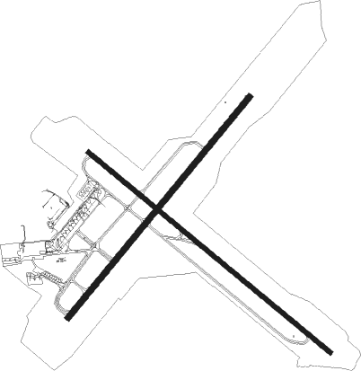
Runway info
Runway 13 / 31  | ||
| length | 3185m (10449ft) | |
| bearing | 123° / 303° | |
| width | 45m (148ft) | |
| surface | concrete | |
| displ threshold | 0m (0ft) / 240m (787ft) | |
| Runway 04 / 22 | ||
| length | 2899m (9511ft) | |
| bearing | 55° / 235° | |
| width | 60m (197ft) | |
| surface | concrete | |
Nearby beacons
| code | identifier | dist | bearing | frequency |
|---|---|---|---|---|
| B | BARKA (BRATISLAVA) NDB | 1.8 | 117° | 438 |
| OKR | STEFANIK NORTH NDB | 4.7 | 57° | 391 |
| OB | STEFANIK SOUTH NDB | 4.9 | 121° | 330 |
| JAN | JANOVCE VOR/DME | 13.5 | 88° | 110.80 |
| BRK | BRUCK NDB | 20.6 | 258° | 408 |
| FMD | FISCHAMEND VOR/DME | 23.4 | 264° | 110.40 |
| WGM | WAGRAM VOR/DME | 30 | 282° | 112.20 |
| NIT | NITRA VOR/DME | 34.5 | 82° | 116.50 |
| PNY | CENTR (PIESTANY) NDB | 36 | 55° | 297 |
| GYR | GYOR VOR/DME | 37 | 135° | 115.10 |
| STE | STEINHOF NDB | 38.4 | 272° | 293 |
| SNU | SOLLENAU VOR/DME | 40.8 | 252° | 115.50 |
| CP | PAPA NDB | 47 | 160° | 318 |
| C | PAPA NDB | 48.6 | 160° | 493 |
| PCT | PAPA VORTAC | 48.7 | 160° | 114.75 |
| P | PAPA NDB | 51 | 160° | 493 |
| PC | PAPA NDB | 52.6 | 159° | 318 |
| KNE | KUNOVICE NDB | 53.5 | 16° | 434 |
| KUN | KUNOVICE NDB | 57.9 | 17° | 416 |
| B | BOREK (BRNO) NDB | 61.7 | 334° | 429 |
| BNO | BRNO VOR/DME | 62.3 | 332° | 114.45 |
Departure and arrival routes
| Transition altitude | 10000ft |
| Transition level | 100ft |
| SID end points | distance | outbound heading | |
|---|---|---|---|
| RW04 | |||
| BERV1Z | 30mi | 37° | |
| NIT1Z | 35mi | 82° | |
| TABI1Z | 36mi | 100° | |
| VAMO1Z | 29mi | 130° | |
| TOVK1L, TOVK1Z | 13mi | 290° | |
| RW13 | |||
| BERV1Y | 30mi | 37° | |
| NIT1Y | 35mi | 82° | |
| TABI1Y | 36mi | 100° | |
| VAMO1Y | 29mi | 130° | |
| TOVK1Y | 13mi | 290° | |
| RW22 | |||
| BERV1B | 30mi | 37° | |
| NIT1B | 35mi | 82° | |
| TABI1B | 36mi | 100° | |
| VAMO1B | 29mi | 130° | |
| TOVK1B | 13mi | 290° | |
| RW31 | |||
| BERV1A | 30mi | 37° | |
| NIT1A | 35mi | 82° | |
| TABI1A | 36mi | 100° | |
| VAMO1A | 29mi | 130° | |
| TOVK1A, TOVK1K | 13mi | 290° | |
| STAR starting points | distance | inbound heading | |
|---|---|---|---|
| RW22 | |||
| BERV3S | 30.0 | 217° | |
| NIT3S | 34.5 | 262° | |
| TABI3S | 36.4 | 280° | |
| XOMB3S | 42.4 | 296° | |
| KUVE2S | 18.2 | 318° | |
| RW31 | |||
| BERV3R | 30.0 | 217° | |
| NIT3R | 34.5 | 262° | |
| TABI3R | 36.4 | 280° | |
| XOMB3R | 42.4 | 296° | |
| KUVE2R | 18.2 | 318° | |
Holding patterns
| STAR name | hold at | type | turn | heading* | altitude | leg | speed limit |
|---|---|---|---|---|---|---|---|
| BERV3R | JAN | NDB | left | 356 (176)° | > 3000ft | DME 4.3mi | ICAO rules |
| KUVE2S | JAN | NDB | left | 356 (176)° | > 3000ft | DME 4.3mi | ICAO rules |
| TABI3S | JAN | NDB | left | 356 (176)° | > 3000ft | DME 4.3mi | ICAO rules |
| XOMB3S | JAN | NDB | left | 356 (176)° | > 3000ft | DME 4.3mi | ICAO rules |
| *) magnetic outbound (inbound) holding course | |||||||
Disclaimer
The information on this website is not for real aviation. Use this data with the X-Plane flight simulator only! Data taken with kind consent from X-Plane 12 source code and data files. Content is subject to change without notice.