Cozumel - Cozumel Intl
Airport details
| Country | Mexico |
| State | Quintana Roo |
| Region | MM |
| Airspace | Merida Ctr |
| Municipality | San Miguel de Cozumel |
| Elevation | 15ft (5m) |
| Timezone | GMT -5 |
| Coordinates | 20.52269, -86.93699 |
| Magnetic var | |
| Type | land |
| Available since | X-Plane v10.40 |
| ICAO code | MMCZ |
| IATA code | CZM |
| FAA code | n/a |
Communication
| Cozumel Intl Tower | 118.000 |
| Cozumel Intl CANCUN Approach | 124.700 |
| Cozumel Intl CANCUN Departure | 124.200 |
Nearby Points of Interest:
Arrecifes de Cozumel National Park
-Arrecife de Puerto Morelos National Park
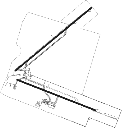
Runway info
Runway 05 / 23  | ||
| length | 3167m (10390ft) | |
| bearing | 57° / 237° | |
| width | 45m (148ft) | |
| surface | asphalt | |
| displ threshold | 595m (1952ft) / 145m (476ft) | |
| Runway 12 / 30 | ||
| length | 2702m (8865ft) | |
| bearing | 114° / 294° | |
| width | 45m (148ft) | |
| surface | asphalt | |
| displ threshold | 198m (650ft) / 0m (0ft) | |
| blast zone | 0m (0ft) / 60m (197ft) | |
Nearby beacons
| code | identifier | dist | bearing | frequency |
|---|---|---|---|---|
| CZM | COZUMEL VOR/DME | 1.6 | 121° | 112.50 |
| CUN | CANCUN VOR/DME | 30.4 | 9° | 113.60 |
| NCP | NICHUPTE VOR/DME | 31.3 | 9° | 114.50 |
Departure and arrival routes
| Transition altitude | 18500ft |
| Transition level | 19500ft |
| SID end points | distance | outbound heading | |
|---|---|---|---|
| RW12 | |||
| NOSU1C | 80mi | 0° | |
| ROTG1C | 81mi | 11° | |
| NUKA1C | 89mi | 51° | |
| BOTO2F | 24mi | 54° | |
| NUDA1C | 86mi | 61° | |
| AVSE1B | 41mi | 102° | |
| GOSUL2 | 27mi | 102° | |
| ITAKU2 | 27mi | 147° | |
| SIGM1A | 63mi | 148° | |
| OBTA1D, OBTA2A | 26mi | 176° | |
| ITPI1C, ITPI2A | 26mi | 188° | |
| DAXU2A, DAXU1C | 25mi | 202° | |
| OTED2A | 25mi | 212° | |
| PAUL1C | 50mi | 214° | |
| AVSI1A | 49mi | 259° | |
| XOSI1A | 48mi | 274° | |
| RW30 | |||
| NOSU1D | 80mi | 0° | |
| ROTG1D | 81mi | 11° | |
| LIDE2E | 15mi | 12° | |
| NUKA1D | 89mi | 51° | |
| NUDA1D | 86mi | 61° | |
| AVSE1C | 41mi | 102° | |
| SIGM1B | 63mi | 148° | |
| OBTA2B, OBTA1C | 26mi | 176° | |
| ITPI2B, ITPI1D | 26mi | 188° | |
| DAXU1D, DAXU2B | 25mi | 202° | |
| OTED2B | 25mi | 212° | |
| PAUL1D | 50mi | 214° | |
| OKUVA2 | 24mi | 257° | |
| AVSI1B | 49mi | 259° | |
| DUPIX2 | 23mi | 273° | |
| XOSI1B | 48mi | 274° | |
| VOBE2E | 30mi | 326° | |
| STAR starting points | distance | inbound heading | |
|---|---|---|---|
| RW12 | |||
| PAUL1E | 50.1 | 34° | |
| AVSI1C | 48.7 | 79° | |
| VIGT1A | 68.6 | 145° | |
| EMOS1A | 97.0 | 218° | |
| ILUB1C | 92.0 | 282° | |
| SIGM1C | 63.1 | 328° | |
| RW30 | |||
| PAUL1F | 50.1 | 34° | |
| AVSI1D | 48.7 | 79° | |
| VIGT1B | 68.6 | 145° | |
| EMOS1B | 97.0 | 218° | |
| ILUB1D | 92.0 | 282° | |
| SIGM1D | 63.1 | 328° | |
Instrument approach procedures
| runway | airway (heading) | route (dist, bearing) |
|---|---|---|
| RW12 | ONGAV (88°) | ONGAV 4000ft CZ519 (5mi, 27°) 2500ft |
| RW12 | VIBLA (140°) | VIBLA 4000ft CZ519 (5mi, 207°) 2500ft |
| RW12 | XUBLI (114°) | XUBLI 4000ft CZ519 (5mi, 114°) 2500ft |
| RNAV | CZ519 2500ft CALHO (5mi, 114°) 1600ft MMCZ (5mi, 112°) 60ft CZ403 (5mi, 117°) DURGA (28mi, 131°) 4000ft DURGA (turn) 4000ft | |
| RW30 | BEREB (319°) | BEREB 4000ft CZ705 (5mi, 27°) 2500ft |
| RW30 | EMPAM (295°) | EMPAM 4000ft CZ705 (5mi, 294°) 2500ft |
| RNAV | CZ705 2500ft CZ706 (5mi, 294°) 1600ft MMCZ (6mi, 296°) 65ft CZ600 (2mi, 288°) EBLOD (32mi, 143°) 4000ft EBLOD (turn) 4000ft |
Disclaimer
The information on this website is not for real aviation. Use this data with the X-Plane flight simulator only! Data taken with kind consent from X-Plane 12 source code and data files. Content is subject to change without notice.