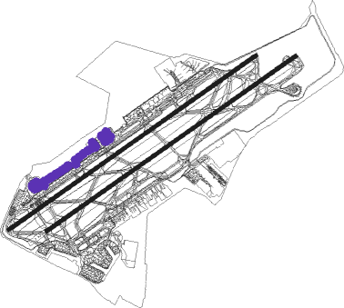
Mexico City - Licenciado Benito Juarez Intl
Airport details
| Country | Mexico |
| State | Distrito Federal |
| Region | MM |
| Airspace | Mexico Ctr |
| Municipality | Mexico City |
| Elevation | 7313ft (2229m) |
| Timezone | GMT -6 |
| Coordinates | 19.43640, -99.07198 |
| Magnetic var | |
| Type | land |
| Available since | X-Plane v10.40 |
| ICAO code | MMMX |
| IATA code | MEX |
| FAA code | n/a |
Communication
| Licenciado Benito Juarez Intl ATIS | 127.650 |
| Licenciado Benito Juarez Intl MEXICO Clearance DEL | 122.100 |
| Licenciado Benito Juarez Intl Ground Control SOUTHWEST | 122.800 |
| Licenciado Benito Juarez Intl Ground Control SOUTH | 121.000 |
| Licenciado Benito Juarez Intl Ground Control NORTH | 121.850 |
| Licenciado Benito Juarez Intl MEXICO Tower | 118.700 |
| Licenciado Benito Juarez Intl MEXICO Tower | 118.550 |
| Licenciado Benito Juarez Intl MEXICO Tower HELOS | 118.150 |
| Licenciado Benito Juarez Intl MEXICO ARR EAST | 120.500 |
| Licenciado Benito Juarez Intl MEXICO ARR WEST | 129.100 |
| Licenciado Benito Juarez Intl MEXICO Departure WEST | 129.100 |
| Licenciado Benito Juarez Intl MEXICO Departure EAST | 120.500 |
Approach frequencies
| ILS-cat-I | RW23L | 109.7 | 18.00mi |
| ILS-cat-I | RW05R | 109.1 | 18.00mi |
| 3.1° GS | RW05R | 109.1 | 18.00mi |
| 3° GS | RW23L | 109.7 | 18.00mi |
Runway info
Nearby beacons
| code | identifier | dist | bearing | frequency |
|---|---|---|---|---|
| MEX | MEXICO VOR/DME | 0.2 | 60° | 115.90 |
| SMO | SAN MATEO VOR/DME | 11.3 | 307° | 112.10 |
| TPX | TEPEXPAN NDB | 12.2 | 33° | 359 |
| SLM | SANTA LUCIA VOR/DME | 18.5 | 8° | 116.60 |
| TLC | TOLUCA VOR/DME | 28.3 | 258° | 114.30 |
| CVJ | CUERNAVACA VOR/DME | 38.3 | 198° | 113.90 |
| APN | APAN VOR/DME | 39.9 | 73° | 114.80 |
| CUA | CUAUTLA VOR/DME | 40.2 | 165° | 116.30 |
| PTJ | PASTEJE VOR/DME | 42.9 | 286° | 114.50 |
| PBC | PUEBLA VOR/DME | 43 | 111° | 115.20 |
| TEQ | TEQUESQUITENGO VOR/DME | 46.8 | 194° | 113.10 |
| PCA | PACHUCA VOR/DME | 47.1 | 29° | 112.70 |
Departure and arrival routes
| Transition altitude | 18500ft |
| Transition level | 19500ft |
| SID end points | distance | outbound heading | |
|---|---|---|---|
| RW05 (ALL) | |||
| IKLA1A | 61mi | 10° | |
| NOXO1A | 61mi | 81° | |
| UKUN1A | 60mi | 90° | |
| ILET1A | 60mi | 99° | |
| TEVO1A | 61mi | 172° | |
| ULEB1A | 66mi | 249° | |
| OVAG1A | 62mi | 257° | |
| SEBO1A | 60mi | 265° | |
| ATUR1A | 61mi | 350° | |
| AXIR1A | 60mi | 360° | |
| RW23 (ALL) | |||
| IKLA1B | 61mi | 10° | |
| NOXO1B | 61mi | 81° | |
| UKUN1B | 60mi | 90° | |
| ILET1B | 60mi | 99° | |
| TEVO1B | 61mi | 172° | |
| ULEB1B | 66mi | 249° | |
| OVAG1B | 62mi | 257° | |
| SEBO1B | 60mi | 265° | |
| ATUR1B | 61mi | 350° | |
| AXIR1B | 60mi | 360° | |
| STAR starting points | distance | inbound heading | |
|---|---|---|---|
| RW05 (ALL) | |||
| ESPO1A | 60.2 | 47° | |
| DARA1A | 60.5 | 138° | |
| ENAG1A | 61.2 | 237° | |
| LARL1A | 60.2 | 314° | |
| RW23 (ALL) | |||
| ESPO1B | 60.2 | 47° | |
| DARA1B | 60.5 | 138° | |
| ENAG1B | 61.2 | 237° | |
| LARL1B | 60.2 | 314° | |
Instrument approach procedures
| runway | airway (heading) | route (dist, bearing) |
|---|---|---|
| RW05L | SUTAS (88°) | SUTAS 11000ft MX930 (5mi, 147°) 9700ft |
| RW05L | VOLUN (33°) | VOLUN 11000ft MX930 (5mi, 334°) 9700ft |
| RNAV | MX930 9700ft MX931 (4mi, 61°) 8900ft MMMX (5mi, 62°) 7350ft MX940 (1mi, 57°) MX941 (8mi, 23°) SLM (10mi, 350°) 12000ft | |
| RW05R | SUTAS (88°) | SUTAS 11000ft MX901 (5mi, 147°) 9700ft |
| RW05R | VOLUN (33°) | VOLUN 11000ft MX901 (5mi, 334°) 9700ft |
| RNAV | MX901 9700ft MX900 (4mi, 61°) 8900ft MMMX (5mi, 60°) 7346ft MMMX (turn) MX950 (10mi, 87°) MX951 (11mi, 180°) VOLUN (15mi, 275°) 11000ft | |
| RW23L | KOZLO (241°) | KOZLO 10000ft MX401 (3mi, 241°) 9000ft |
| RNAV | MX401 9000ft MX400 (2mi, 241°) 8900ft MMMX (6mi, 241°) 7353ft MX410 (6mi, 240°) MX411 (13mi, 148°) MX412 (16mi, 61°) 11000ft MX413 (8mi, 335°) KOZLO (5mi, 328°) | |
| RW23R | KOZLO (241°) | KOZLO 10000ft MX450 (3mi, 244°) 9000ft |
| RNAV | MX450 9000ft MX451 (2mi, 241°) 8900ft MMMX (6mi, 240°) 7351ft MX460 (5mi, 242°) SMO (11mi, 335°) MX461 (6mi, 58°) 11000ft MX462 (10mi, 61°) KOZLO (11mi, 151°) |
Disclaimer
The information on this website is not for real aviation. Use this data with the X-Plane flight simulator only! Data taken with kind consent from X-Plane 12 source code and data files. Content is subject to change without notice.

