Nassau - Lynden Pindling Intl (nassau)
Airport details
| Country | Bahamas |
| State | New Providence |
| Region | MY |
| Airspace | Nassau Ctr |
| Elevation | 16ft (5m) |
| Timezone | GMT -5 |
| Coordinates | 25.03901, -77.46619 |
| Magnetic var | |
| Type | land |
| Available since | X-Plane v10.40 |
| ICAO code | MYNN |
| IATA code | NAS |
| FAA code | n/a |
Communication
| Lynden Pindling Intl (Nassau) ATIS | 118.700 |
| Lynden Pindling Intl (Nassau) AWOS-2 at MYEH | 118.100 |
| Lynden Pindling Intl (Nassau) AWOS-2 at MYEM | 118.200 |
| Lynden Pindling Intl (Nassau) UNICOM | 122.800 |
| Lynden Pindling Intl (Nassau) Clearance DEL | 118.300 |
| Lynden Pindling Intl (Nassau) Nassau Ground Control | 121.700 |
| Lynden Pindling Intl (Nassau) Nassau Tower | 119.500 |
| Lynden Pindling Intl (Nassau) Approach | 125.300 |
| Lynden Pindling Intl (Nassau) Nassau Approach Primary | 121.100 |
| Lynden Pindling Intl (Nassau) Nassau Approach Secondary | 125.300 |
| Lynden Pindling Intl (Nassau) Departure | 125.300 |
Approach frequencies
| ILS-cat-I | RW14 | 110.1 | 18.00mi |
| 3° GS | RW14 | 110.1 | 18.00mi |
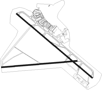
Runway info
Runway 14 / 32  | ||
| length | 3334m (10938ft) | |
| bearing | 132° / 312° | |
| width | 46m (150ft) | |
| surface | asphalt | |
| blast zone | 65m (213ft) / 82m (269ft) | |
| Runway 10 / 28 | ||
| length | 2533m (8310ft) | |
| bearing | 90° / 270° | |
| width | 46m (150ft) | |
| surface | asphalt | |
| displ threshold | 92m (302ft) / 0m (0ft) | |
Nearby beacons
| code | identifier | dist | bearing | frequency |
|---|---|---|---|---|
| ZQA | NASSAU VOR/DME | 1.3 | 124° | 112.70 |
| ZCC | CHUB BAY NDB | 32.1 | 312° | 302 |
Departure and arrival routes
| Transition altitude | 18000ft |
| Transition level | 18000ft |
| SID end points | distance | outbound heading | |
|---|---|---|---|
| RW14 | |||
| INGRA2 | 29mi | 30° | |
| FREDY2 | 39mi | 322° | |
| RW32 | |||
| JAVIS2 | 39mi | 322° | |
Instrument approach procedures
| runway | airway (heading) | route (dist, bearing) |
|---|---|---|
| RW10 | ATADE (68°) | ATADE 2000ft JOBIB (5mi, 360°) 2000ft |
| RW10 | RELVE (109°) | RELVE 2000ft JOBIB (5mi, 179°) 2000ft |
| RNAV | JOBIB 2000ft MOLEE (6mi, 90°) 1600ft 17THR (3mi, 90°) 620ft MYNN (3mi, 86°) 64ft (4724mi, 108°) 500ft ATADE (4735mi, 288°) 2000ft ATADE (turn) 2000ft | |
| RW14 | HEKOP (157°) | HEKOP LAPSE (5mi, 227°) 2000ft |
| RW14 | RELVE (109°) | RELVE LAPSE (5mi, 47°) 2000ft |
| RNAV | LAPSE 2000ft HUTEX (6mi, 132°) 1600ft MYNN (6mi, 134°) 65ft (4724mi, 108°) 460ft HEKOP (4730mi, 288°) 2000ft HEKOP (turn) | |
| RW32 | HIDNO (335°) | HIDNO CUDLI (5mi, 47°) 2000ft |
| RW32 | ZUTUN (289°) | ZUTUN CUDLI (5mi, 227°) 2000ft |
| RNAV | CUDLI 2000ft DILPE (6mi, 312°) 1600ft MYNN (6mi, 310°) 64ft (4724mi, 108°) 420ft ZUTUN (4712mi, 288°) 2000ft ZUTUN (turn) |
Disclaimer
The information on this website is not for real aviation. Use this data with the X-Plane flight simulator only! Data taken with kind consent from X-Plane 12 source code and data files. Content is subject to change without notice.