Turlock - Turlock Muni
Airport details
| Country | United States of America |
| State | California |
| Region | K2 |
| Airspace | Oakland Ctr |
| Municipality | Merced County |
| Elevation | 159ft (48m) |
| Timezone | GMT -8 |
| Coordinates | 37.48397, -120.69722 |
| Magnetic var | |
| Type | land |
| Available since | X-Plane v10.40 |
| ICAO code | O15 |
| IATA code | n/a |
| FAA code | n/a |
Communication
| Turlock Muni CTAF/UNICOM | 122.800 |
Nearby Points of Interest:
Bloss Mansion
-Merced County High School
-Kaehler-Rector House
-Bank of Italy
-Leggett House
-Maj. George Beecher Cook House
-United States Post Office (Merced, California)
-Thomas H. Leggett House
-Odd Fellows Hall
-Old La Grange Schoolhouse
-Old Adobe Barn
-McHenry Mansion
-El Viejo Post Office
-Hornitos Masonic Hall No. 98
-Bank of Los Banos Building
-Church of St. Joseph
-John Ohm House
-Honigsberger Store
-Reed's Store
-Copperopolis Armory
-Copperopolis Congregational Church
-Track Bus No. 19
Runway info
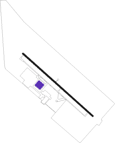
| Runway 12 / 30 | ||
| length | 912m (2992ft) | |
| bearing | 130° / 310° | |
| width | 15m (50ft) | |
| surface | asphalt | |
Nearby beacons
| code | identifier | dist | bearing | frequency |
|---|---|---|---|---|
| MOD | MODESTO VOR/DME | 15.1 | 299° | 114.60 |
| HYP | EL NIDO (MERCED) VOR/DME | 21.2 | 132° | 114.20 |
| LIN | LINDEN VOR/DME | 38.3 | 333° | 114.80 |
| PXN | PANOCHE VORTAC | 46.3 | 186° | 112.60 |
| LV | REIGA (LIVERMORE) NDB | 48.6 | 282° | 374 |
| CZQ | CLOVIS (FRESNO) VORTAC | 55.4 | 124° | 112.90 |
| SNS | SALINAS VORTAC | 65.6 | 228° | 117.30 |
| UAD | CHUALAR (SALINAS) NDB | 70.3 | 218° | 263 |
| SAC | SACRAMENTO VORTAC | 70.4 | 318° | 115.20 |
Disclaimer
The information on this website is not for real aviation. Use this data with the X-Plane flight simulator only! Data taken with kind consent from X-Plane 12 source code and data files. Content is subject to change without notice.