King Abdulaziz Ab
Airport details
| Country | Saudi Arabia |
| State | Eastern Province |
| Region | OE |
| Airspace | Jeddah Ctr |
| Municipality | Dhahran |
| Elevation | 83ft (25m) |
| Timezone | GMT +3 |
| Coordinates | 26.26429, 50.15247 |
| Magnetic var | |
| Type | land |
| Available since | X-Plane v10.40 |
| ICAO code | OEDR |
| IATA code | DHA |
| FAA code | n/a |
Communication
| King Abdulaziz AB ATIS | 117.200 |
| King Abdulaziz AB Ground Control | 121.700 |
| King Abdulaziz AB West Dharan Tower | 118.400 |
| King Abdulaziz AB East Dharan Tower | 118.700 |
| King Abdulaziz AB Dharan Approach | 124.650 |
| King Abdulaziz AB Dharan Approach | 125.400 |
Approach frequencies
| ILS-cat-I | RW34R | 109.9 | 18.00mi |
| ILS-cat-I | RW16L | 109.3 | 18.00mi |
| ILS-cat-I | RW16R | 109.1 | 18.00mi |
| ILS-cat-I | RW34L | 109.7 | 18.00mi |
| 3.2° GS | RW16L | 109.3 | 18.00mi |
| 3° GS | RW34R | 109.9 | 18.00mi |
| 3° GS | RW16R | 109.1 | 18.00mi |
| 3° GS | RW34L | 109.7 | 18.00mi |
Nearby Points of Interest:
Manama
-Bahrain Pearling Trail
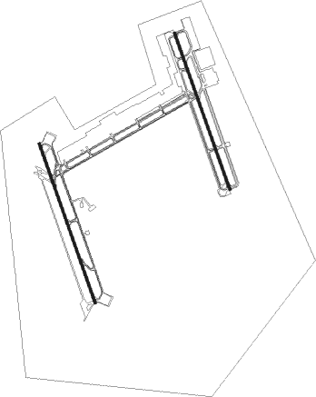
Runway info
Runway 16R / 34L  | ||
| length | 3673m (12051ft) | |
| bearing | 163° / 343° | |
| width | 45m (148ft) | |
| surface | asphalt | |
| blast zone | 255m (837ft) / 255m (837ft) | |
| Runway 16L / 34R | ||
| length | 3613m (11854ft) | |
| bearing | 163° / 343° | |
| width | 45m (148ft) | |
| surface | asphalt | |
| blast zone | 120m (394ft) / 110m (361ft) | |
Nearby beacons
| code | identifier | dist | bearing | frequency |
|---|---|---|---|---|
| DHA | DHAHRAN VORTAC | 0.6 | 254° | 117.20 |
| KFA | DAMMAM VORTAC | 24.5 | 302° | 112.30 |
| BHR | BAHRAIN VOR/DME | 27 | 91° | 111.80 |
| RT | RAS TANURA NDB | 27.4 | 346° | 286 |
| SIA | ISA AB (BAHRAIN) VORTAC | 31.3 | 128° | 117.60 |
| SI | ISA AB (BAHRAIN) NDB | 32.9 | 129° | 343 |
| AQ | ABQAIQ NDB | 36.9 | 237° | 290 |
| NJL | KING ABDULAZIZ NAVAL BASE VORTAC | 47.3 | 327° | 114.80 |
| JBL | JUBAIL VOR/DME | 59.9 | 315° | 112.90 |
| HSA | AL AHSA VORTAC | 69.3 | 214° | 116.60 |
Disclaimer
The information on this website is not for real aviation. Use this data with the X-Plane flight simulator only! Data taken with kind consent from X-Plane 12 source code and data files. Content is subject to change without notice.