Beirut - Rafic Hariri International
Airport details
| Country | Lebanon |
| State | Mount Lebanon Governorate |
| Region | OL |
| Airspace | Beirut Ctr |
| Municipality | Aley District |
| Elevation | 83ft (25m) |
| Timezone | GMT +2 |
| Coordinates | 33.82968, 35.49094 |
| Magnetic var | |
| Type | land |
| Available since | X-Plane v10.40 |
| ICAO code | OLBA |
| IATA code | BEY |
| FAA code | n/a |
Communication
| Rafic Hariri International ATIS | 120.600 |
| Rafic Hariri International Ground Control | 121.900 |
| Rafic Hariri International Tower | 118.900 |
| Rafic Hariri International CNTR | 119.300 |
| Rafic Hariri International Approach | 120.300 |
Approach frequencies
| ILS-cat-I | RW17 | 109.5 | 18.00mi |
| ILS-cat-I | RW16 | 110.1 | 18.00mi |
| ILS-cat-I | RW03 | 110.7 | 18.00mi |
| 3° GS | RW17 | 109.5 | 18.00mi |
| 3° GS | RW16 | 110.1 | 18.00mi |
| 3° GS | RW03 | 110.7 | 18.00mi |
Nearby Points of Interest:
Commemorative stelae of Nahr el-Kalb
-Chouf District
-Aammiq Wetland
-Sidon
-hôpital Saint-Michel d'Amchit
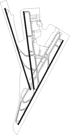
Runway info
Runway 03 / 21  | ||
| length | 3812m (12507ft) | |
| bearing | 38° / 218° | |
| width | 42m (138ft) | |
| surface | concrete | |
| displ threshold | 562m (1844ft) / 995m (3264ft) | |
| blast zone | 112m (367ft) / 118m (387ft) | |
| Runway 16 / 34 | ||
| length | 3399m (11152ft) | |
| bearing | 164° / 344° | |
| width | 43m (141ft) | |
| surface | concrete | |
| displ threshold | 179m (587ft) / 0m (0ft) | |
| blast zone | 122m (400ft) / 110m (361ft) | |
| Runway 17 / 35 | ||
| length | 3109m (10200ft) | |
| bearing | 176° / 356° | |
| width | 45m (148ft) | |
| surface | concrete | |
| displ threshold | 0m (0ft) / 695m (2280ft) | |
| blast zone | 50m (164ft) / 15m (49ft) | |
Nearby beacons
| code | identifier | dist | bearing | frequency |
|---|---|---|---|---|
| KAD | KALDE VOR/DME | 1.3 | 193° | 112.60 |
| BOD | BOD NDB | 4.4 | 353° | 351 |
| BAR | BAYSUR VOR | 4.8 | 133° | 113.90 |
| CAK | CHEKA VOR/DME | 30.1 | 24° | 116.20 |
| MEZ | MEZZEH (DAMASCUS) NDB | 42.1 | 115° | 358 |
| ROP | ROSH-PINA VOR/DME | 51 | 174° | 115.30 |
| RA | KLEYATE NDB | 52 | 34° | 450 |
| ABD | ABYAD (DAMASCUS) NDB | 55.5 | 118° | 264 |
| DAM | DAMASCUS VOR/DME | 56.3 | 115° | 116 |
Departure and arrival routes
| Transition altitude | 13000ft |
| Transition level | 15000ft |
| SID end points | distance | outbound heading | |
|---|---|---|---|
| RW03 | |||
| LEBO1E | 60mi | 68° | |
| LATE1E | 47mi | 77° | |
| RW17 | |||
| BOD1, LEBO1D | 60mi | 68° | |
| LATE1D | 47mi | 77° | |
| RW21 | |||
| BOD1, LEBO1D | 60mi | 68° | |
| LATE1D | 47mi | 77° | |
| RW34 | |||
| BOD2, LEBO2F | 60mi | 68° | |
| LATE2F | 47mi | 77° | |
| RW35 | |||
| BOD2, LEBO2F | 60mi | 68° | |
| LATE2F | 47mi | 77° | |
| STAR starting points | distance | inbound heading | |
|---|---|---|---|
| RW03 | |||
| ELIK1N, ELIK2N | 45.2 | 90° | |
| KUKL1N, KUKL2N | 44.6 | 119° | |
| BALM2N, BALM1N | 44.8 | 146° | |
| LEBO2N, CAK1N | 60.3 | 248° | |
| RW16 | |||
| ELIK1X, ELIK2F | 45.2 | 90° | |
| KUKL1X, KUKL2F | 44.6 | 119° | |
| BALM1X, BALM2F | 44.8 | 146° | |
| LEBO1X, CAK2F | 60.3 | 248° | |
| RW17 | |||
| ELIK1A, ELIK2A | 45.2 | 90° | |
| KUKL1A, KUKL2A | 44.6 | 119° | |
| BALM1A, BALM2A | 44.8 | 146° | |
| BYBL1A, LEBO2A | 60.3 | 248° | |
| RW21 | |||
| ELIK1R | 45.2 | 90° | |
| KUKL1R | 44.6 | 119° | |
| BALM1R | 44.8 | 146° | |
| LEBO1R | 30.1 | 204° | |
Instrument approach procedures
| runway | airway (heading) | route (dist, bearing) |
|---|---|---|
| RW03 | RAMLA (36°) | RAMLA 3000ft BA403 (5mi, 37°) 2000ft |
| RNAV | BA403 2000ft BA404 (5mi, 37°) 2000ft BA405 (4mi, 37°) 635ft (2846mi, 226°) 635ft (turn) 2000ft | |
| RW16 | ZALKA (162°) | ZALKA 3000ft BA406 (5mi, 164°) 2000ft |
| RNAV | BA406 2000ft BA413 (3mi, 164°) 2000ft BA414 (5mi, 164°) 423ft (2849mi, 226°) 490ft (turn) 2000ft | |
| RW17 | BYBLO (176°) | BYBLO 4000ft BOD (14mi, 177°) 1400ft |
| RNAV | BOD 1400ft BA421 (3mi, 176°) 309ft (2850mi, 226°) 490ft (turn) 2000ft | |
| RW21 | BA417 (193°) | BA417 4000ft BA418 (8mi, 174°) 2100ft |
| RNAV | BA418 2100ft BA419 (5mi, 207°) 731ft (2851mi, 226°) 731ft (turn) 2000ft |
Holding patterns
| STAR name | hold at | type | turn | heading* | altitude | leg | speed limit |
|---|---|---|---|---|---|---|---|
| BALM1A | BYBLO | VHF | right | 352 (172)° | > 5000ft | DME 6.0mi | 230 |
| BALM1N | RAMLA | VHF | left | 208 (28)° | > 3000ft | DME 6.0mi | 230 |
| BALM1R | BA417 | VHF | right | 352 (172)° | > 4000ft | DME 6.0mi | 230 |
| BALM1X | ZALKA | VHF | right | 342 (162)° | > 3000ft | DME 6.0mi | 230 |
| BALM2A | BYBLO | VHF | right | 352 (172)° | > 5000ft | DME 6.0mi | 230 |
| BALM2F | ZALKA | VHF | right | 342 (162)° | > 3000ft | DME 6.0mi | 230 |
| BALM2N | RAMLA | VHF | left | 208 (28)° | > 3000ft | DME 6.0mi | 230 |
| BYBL1A | BYBLO | VHF | right | 352 (172)° | > 5000ft | DME 6.0mi | 230 |
| CAK1N | RAMLA | VHF | left | 208 (28)° | > 3000ft | DME 6.0mi | 230 |
| CAK2F | ZALKA | VHF | right | 342 (162)° | > 3000ft | DME 6.0mi | 230 |
| ELIK1A | BYBLO | VHF | right | 352 (172)° | > 5000ft | DME 6.0mi | 230 |
| ELIK1N | RAMLA | VHF | left | 208 (28)° | > 3000ft | DME 6.0mi | 230 |
| ELIK1R | BA417 | VHF | right | 352 (172)° | > 4000ft | DME 6.0mi | 230 |
| ELIK1X | ZALKA | VHF | right | 342 (162)° | > 3000ft | DME 6.0mi | 230 |
| ELIK2A | BYBLO | VHF | right | 352 (172)° | > 5000ft | DME 6.0mi | 230 |
| ELIK2F | ZALKA | VHF | right | 342 (162)° | > 3000ft | DME 6.0mi | 230 |
| ELIK2N | RAMLA | VHF | left | 208 (28)° | > 3000ft | DME 6.0mi | 230 |
| KAD1A | BYBLO | VHF | right | 352 (172)° | > 5000ft | DME 6.0mi | 230 |
| KAD1N | RAMLA | VHF | left | 208 (28)° | > 3000ft | DME 6.0mi | 230 |
| KAD2F | ZALKA | VHF | right | 342 (162)° | > 3000ft | DME 6.0mi | 230 |
| KUKL1A | BYBLO | VHF | right | 352 (172)° | > 5000ft | DME 6.0mi | 230 |
| KUKL1N | RAMLA | VHF | left | 208 (28)° | > 3000ft | DME 6.0mi | 230 |
| KUKL1R | BA417 | VHF | right | 352 (172)° | > 4000ft | DME 6.0mi | 230 |
| KUKL1X | ZALKA | VHF | right | 342 (162)° | > 3000ft | DME 6.0mi | 230 |
| KUKL2A | BYBLO | VHF | right | 352 (172)° | > 5000ft | DME 6.0mi | 230 |
| KUKL2F | ZALKA | VHF | right | 342 (162)° | > 3000ft | DME 6.0mi | 230 |
| KUKL2N | RAMLA | VHF | left | 208 (28)° | > 3000ft | DME 6.0mi | 230 |
| LEBO1R | BA417 | VHF | right | 352 (172)° | > 4000ft | DME 6.0mi | 230 |
| LEBO1X | ZALKA | VHF | right | 342 (162)° | > 3000ft | DME 6.0mi | 230 |
| LEBO2A | BYBLO | VHF | right | 352 (172)° | > 5000ft | DME 6.0mi | 230 |
| LEBO2N | RAMLA | VHF | left | 208 (28)° | > 3000ft | DME 6.0mi | 230 |
| *) magnetic outbound (inbound) holding course | |||||||
Disclaimer
The information on this website is not for real aviation. Use this data with the X-Plane flight simulator only! Data taken with kind consent from X-Plane 12 source code and data files. Content is subject to change without notice.