Dubai - Dubai Intl
Airport details
| Country | United Arab Emirates |
| State | Dubai |
| Region | OM |
| Airspace | Emirates Ctr |
| Municipality | Dubai International Airport |
| Elevation | 62ft (19m) |
| Timezone | GMT +4 |
| Coordinates | 25.25278, 55.36444 |
| Magnetic var | |
| Type | land |
| Available since | X-Plane v10.40 |
| ICAO code | OMDB |
| IATA code | DXB |
| FAA code | n/a |
Communication
| Dubai Intl Dubai ATIS Departure | 131.700 |
| Dubai Intl Dubai ATIS Arrival | 126.275 |
| Dubai Intl Dubai Delivery | 120.350 |
| Dubai Intl Dubai Ground 2 | 118.850 |
| Dubai Intl Dubai Ground 1 | 118.350 |
| Dubai Intl Dubai Tower Air 2 | 119.550 |
| Dubai Intl Dubai Tower Air 1 | 118.750 |
| Dubai Intl Dubai Arrival 2 | 120.250 |
| Dubai Intl Dubai Arrival 1 | 124.900 |
| Dubai Intl Dubai Departure North | 126.200 |
| Dubai Intl Dubai Departure South | 122.500 |
Approach frequencies
| ILS-cat-III | RW12R | 109.5 | 18.00mi |
| ILS-cat-III | RW12L | 110.1 | 18.00mi |
| ILS-cat-III | RW30R | 110.9 | 18.00mi |
| ILS-cat-III | RW30L | 111.3 | 18.00mi |
| 3° GS | RW12R | 109.5 | 18.00mi |
| 3° GS | RW12L | 110.1 | 18.00mi |
| 3° GS | RW30R | 110.9 | 18.00mi |
| 3° GS | RW30L | 111.3 | 18.00mi |
Nearby Points of Interest:
Dubai Creek
-Sharjah
-Ed-Dur
Runway info
Runway 12R / 30L  | ||
| length | 4447m (14590ft) | |
| bearing | 119° / 299° | |
| width | 60m (197ft) | |
| surface | asphalt | |
| displ threshold | 718m (2356ft) / 134m (440ft) | |
| blast zone | 217m (712ft) / 255m (837ft) | |
| Runway 12L / 30R | ||
| length | 4343m (14249ft) | |
| bearing | 119° / 299° | |
| width | 60m (197ft) | |
| surface | asphalt | |
| displ threshold | 441m (1447ft) / 302m (991ft) | |
| blast zone | 120m (394ft) / 123m (404ft) | |
Airport layout
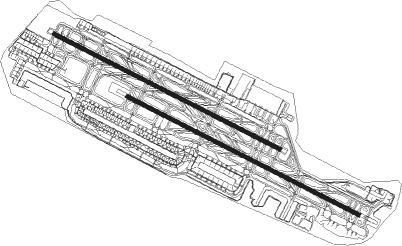
Taxiway locations
Parking locations
|
Nearby beacons
| code | identifier | dist | bearing | frequency |
|---|---|---|---|---|
| MIN | MINHAD VOR/DME | 13.6 | 172° | 115.20 |
| RAV | RAS AL KHAIMAH VOR/DME | 37.4 | 60° | 113.60 |
| ABM | ABUMUSA ISLAND NDB | 41.8 | 331° | 285 |
| FJV | FUJAIRAH VOR/DME | 54.5 | 99° | 113.80 |
| SIR | SIRRI ISLAND NDB | 59.2 | 308° | 300 |
| ALA | AL AIN VOR/DME | 59.8 | 166° | 115.90 |
| SIR | SIRRI ISLAND VOR/DME | 59.9 | 309° | 113.75 |
| ALN | AL AIN VOR/DME | 61 | 166° | 112.60 |
| ADV | ABU DHABI VOR/DME | 62.6 | 220° | 114.25 |
| ALB | AL BATEEN (ABU DHABI) VOR/DME | 69.9 | 228° | 114 |
Departure and arrival routes
| Transition altitude | 13000ft |
| Transition level | 15000ft |
| SID end points | distance | outbound heading | |
|---|---|---|---|
| RW12 (ALL) | |||
| DAVM4G | 39mi | 25° | |
| IVUR1G | 43mi | 85° | |
| ANVI5G | 42mi | 129° | |
| EMER2G | 32mi | 215° | |
| KUTL4G | 33mi | 228° | |
| MIRO3G | 47mi | 260° | |
| NABI3G | 45mi | 267° | |
| SENP3G | 45mi | 276° | |
| RIDA3G | 42mi | 283° | |
| RW30 (ALL) | |||
| DAVM4F | 39mi | 25° | |
| IVUR1F | 43mi | 85° | |
| ANVI7F | 42mi | 129° | |
| EMER2F | 32mi | 215° | |
| KUTL4F | 33mi | 228° | |
| MIRO3F | 47mi | 260° | |
| NABI3F | 45mi | 267° | |
| SENP2F | 45mi | 276° | |
| RIDA2F | 42mi | 283° | |
| STAR starting points | distance | inbound heading | |
|---|---|---|---|
| RW12 (ALL) | |||
| LORI1E | 43.3 | 66° | |
| DATO1E | 35.2 | 114° | |
| VUTE3E, VUTE3B | 34.7 | 126° | |
| PUVA5B, PUVA2E | 28.2 | 225° | |
| IMPE3E, IMPE3B | 41.7 | 292° | |
| RW30 (ALL) | |||
| LORI4D, LORI3C | 43.3 | 66° | |
| DATO4D, DATO3C | 35.2 | 114° | |
| VUTE3C, VUTE3D | 34.7 | 126° | |
| PUVA2D, PUVA5C | 28.2 | 225° | |
| IMPE3C | 41.7 | 292° | |
Instrument approach procedures
| runway | airway (heading) | route (dist, bearing) |
|---|---|---|
| RW12L | REREK (120°) | REREK 2000ft UKRIM (4mi, 119°) 2000ft |
| RNAV | UKRIM 2000ft DB601 (5mi, 119°) 2000ft OMDB (8mi, 120°) 61ft DB611 (1mi, 111°) TALTU (14mi, 105°) 3000ft TALTU (turn) 3000ft | |
| RW12R | REREK (120°) | REREK 3000ft PEDOV (5mi, 121°) 3000ft |
| RNAV | PEDOV 3000ft DB658 (2mi, 119°) 3000ft OMDB (10mi, 119°) 64ft DB614 (2mi, 119°) DB655 (12mi, 134°) 4000ft TALTU (7mi, 49°) 4000ft TALTU (turn) 4000ft | |
| RW30L | ULDOT (299°) | ULDOT 2000ft SEDPO (5mi, 299°) 2000ft |
| RNAV | SEDPO 2000ft DB713 (4mi, 299°) 2000ft OMDB (8mi, 299°) 110ft DB707 (1mi, 299°) EGNOT (14mi, 285°) 3000ft EGNOT (turn) 3000ft | |
| RW30R | ULDOT (299°) | ULDOT 3000ft LOVOL (4mi, 302°) 3000ft |
| RNAV | LOVOL 3000ft DB780 (2mi, 299°) 3000ft OMDB (11mi, 298°) 85ft DB755 (1mi, 307°) DB756 (12mi, 314°) 4000ft EGNOT (7mi, 229°) 4000ft EGNOT (turn) 4000ft |
Holding patterns
| STAR name | hold at | type | turn | heading* | altitude | leg | speed limit |
|---|---|---|---|---|---|---|---|
| DATO1E | SOLIL | VHF | left | 120 (300)° | 4000ft - 6000ft | 1.0min timed | 210 |
| DATO3C | VELAR | VHF | left | 300 (120)° | 4000ft - 6000ft | 1.0min timed | 210 |
| DATO4D | TUKAK | VHF | left | 300 (120)° | 4000ft - 6000ft | 1.0min timed | 210 |
| IMPE3B | PASEV | VHF | right | 119 (299)° | 4000ft - 6000ft | 1.0min timed | 210 |
| IMPE3C | VELAR | VHF | left | 300 (120)° | 4000ft - 6000ft | 1.0min timed | 210 |
| IMPE3E | SOLIL | VHF | left | 120 (300)° | 4000ft - 6000ft | 1.0min timed | 210 |
| LORI1E | SOLIL | VHF | left | 120 (300)° | 4000ft - 6000ft | 1.0min timed | 210 |
| LORI3C | VELAR | VHF | left | 300 (120)° | 4000ft - 6000ft | 1.0min timed | 210 |
| LORI4D | TUKAK | VHF | left | 300 (120)° | 4000ft - 6000ft | 1.0min timed | 210 |
| PUVA2D | TUKAK | VHF | left | 300 (120)° | 4000ft - 6000ft | 1.0min timed | 210 |
| PUVA2E | SOLIL | VHF | left | 120 (300)° | 4000ft - 6000ft | 1.0min timed | 210 |
| PUVA5B | PASEV | VHF | right | 119 (299)° | 4000ft - 6000ft | 1.0min timed | 210 |
| PUVA5C | VELAR | VHF | left | 300 (120)° | 4000ft - 6000ft | 1.0min timed | 210 |
| VUTE3B | PASEV | VHF | right | 119 (299)° | 4000ft - 6000ft | 1.0min timed | 210 |
| VUTE3C | VELAR | VHF | left | 300 (120)° | 4000ft - 6000ft | 1.0min timed | 210 |
| VUTE3D | TUKAK | VHF | left | 300 (120)° | 4000ft - 6000ft | 1.0min timed | 210 |
| VUTE3E | SOLIL | VHF | left | 120 (300)° | 4000ft - 6000ft | 1.0min timed | 210 |
| *) magnetic outbound (inbound) holding course | |||||||
Disclaimer
The information on this website is not for real aviation. Use this data with the X-Plane flight simulator only! Data taken with kind consent from X-Plane 12 source code and data files. Content is subject to change without notice.