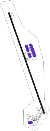
Ras Al Khaimah - Ras Al Khaimah Internatinal
Airport details
| Country | United Arab Emirates |
| State | Ras al-Khaimah |
| Region | OM |
| Airspace | Emirates Ctr |
| Elevation | 102ft (31m) |
| Timezone | GMT +4 |
| Coordinates | 25.61333, 55.93889 |
| Magnetic var | |
| Type | land |
| Available since | X-Plane v10.40 |
| ICAO code | OMRK |
| IATA code | RKT |
| FAA code | n/a |
Communication
| Ras Al Khaimah Internatinal Ground Control | 121.600 |
| Ras Al Khaimah Internatinal Tower | 118.250 |
Approach frequencies
| ILS-cat-I | RW34 | 110.5 | 18.00mi |
| 3° GS | RW34 | 110.5 | 18.00mi |
Runway info
| Runway 16 / 34 | ||
| length | 3777m (12392ft) | |
| bearing | 163° / 343° | |
| width | 45m (148ft) | |
| surface | asphalt | |
| blast zone | 50m (164ft) / 50m (164ft) | |
Nearby beacons
| code | identifier | dist | bearing | frequency |
|---|---|---|---|---|
| RAV | RAS AL KHAIMAH VOR/DME | 1.5 | 163° | 113.60 |
| FJV | FUJAIRAH VOR/DME | 38.1 | 141° | 113.80 |
| MIN | MINHAD VOR/DME | 45.9 | 223° | 115.20 |
| ABM | ABUMUSA ISLAND NDB | 52 | 286° | 285 |
Departure and arrival routes
| Transition altitude | 13000ft |
| Transition level | 15000ft |
| SID end points | distance | outbound heading | |
|---|---|---|---|
| RW16 | |||
| EMOP2S | 16mi | 130° | |
| PUVA1S | 12mi | 266° | |
| ASNE1E, ASNE1W | 21mi | 340° | |
| RW34 | |||
| EMOP2E, EMOP2W | 16mi | 130° | |
| PUVA1N | 12mi | 266° | |
| ASNE1N | 21mi | 340° | |
| STAR starting points | distance | inbound heading | |
|---|---|---|---|
| RW16 | |||
| ALSI1N | 11.5 | 52° | |
| EGPE2N | 21.0 | 186° | |
| LAGL2E, LAGL2W | 21.1 | 306° | |
| NADN2E, NADN2W | 17.5 | 358° | |
| RW34 | |||
| ALSI1S | 11.5 | 52° | |
| EGPE1E, EGPE2W | 21.0 | 186° | |
| LAGL1S | 21.1 | 306° | |
| NADN2S | 17.5 | 358° | |
Instrument approach procedures
| runway | airway (heading) | route (dist, bearing) |
|---|---|---|
| RW16 | BOTUT (138°) | BOTUT 3000ft EGMAP (5mi, 76°) 2000ft |
| RW16 | DARIV (189°) | DARIV 3000ft EGMAP (5mi, 256°) 2000ft |
| RNAV | EGMAP 2000ft RK671 (4mi, 163°) 2000ft RK162 (4mi, 163°) 860ft OMRK (4mi, 163°) 114ft RK661 (7mi, 163°) ASKUM (9mi, 309°) 3000ft ASKUM (turn) 3000ft | |
| RW34 | EGLOP (7°) | EGLOP 3000ft BOSEG (5mi, 76°) 2600ft |
| RW34 | GEVAM (320°) | GEVAM 3500ft BOSEG (5mi, 256°) 2600ft |
| RNAV | BOSEG 2600ft RK661 (5mi, 343°) 2000ft RK342 (4mi, 343°) 740ft OMRK (3mi, 343°) 144ft EGMAP (12mi, 343°) EGMAP (turn) 3000ft |
Holding patterns
| STAR name | hold at | type | turn | heading* | altitude | leg | speed limit |
|---|---|---|---|---|---|---|---|
| ALSI1N | ASKUM | VHF | right | 163 (343)° | 3000ft - 6000ft | 1.0min timed | 210 |
| ALSI1N | EGMAP | VHF | right | 343 (163)° | 3000ft - 6000ft | 1.0min timed | 210 |
| EGPE2N | EGMAP | VHF | right | 343 (163)° | 3000ft - 6000ft | 1.0min timed | 210 |
| EGPE2W | ITIKO | VHF | left | 343 (163)° | 3000ft - 6000ft | 1.0min timed | 210 |
| LAGL2E | EGMAP | VHF | right | 343 (163)° | 3000ft - 6000ft | 1.0min timed | 210 |
| LAGL2W | ASKUM | VHF | right | 163 (343)° | 3000ft - 6000ft | 1.0min timed | 210 |
| LAGL2W | EGMAP | VHF | right | 343 (163)° | 3000ft - 6000ft | 1.0min timed | 210 |
| NADN2E | EGMAP | VHF | right | 343 (163)° | 3000ft - 6000ft | 1.0min timed | 210 |
| NADN2W | ASKUM | VHF | right | 163 (343)° | 3000ft - 6000ft | 1.0min timed | 210 |
| NADN2W | EGMAP | VHF | right | 343 (163)° | 3000ft - 6000ft | 1.0min timed | 210 |
| *) magnetic outbound (inbound) holding course | |||||||
Disclaimer
The information on this website is not for real aviation. Use this data with the X-Plane flight simulator only! Data taken with kind consent from X-Plane 12 source code and data files. Content is subject to change without notice.
