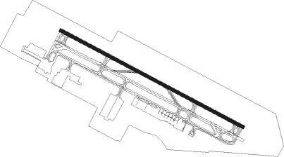
Sharjah - Sharjah Intl
Airport details
| Country | United Arab Emirates |
| State | Sharjah Emirate |
| Region | OM |
| Airspace | Emirates Ctr |
| Municipality | Sharjah |
| Elevation | 107ft (33m) |
| Timezone | GMT +4 |
| Coordinates | 25.33502, 55.49653 |
| Magnetic var | |
| Type | land |
| Available since | X-Plane v10.40 |
| ICAO code | OMSJ |
| IATA code | SHJ |
| FAA code | n/a |
Communication
| Sharjah Intl ATIS | 122.400 |
| Sharjah Intl DUBAI DIR | 127.900 |
| Sharjah Intl Ground Control | 121.875 |
| Sharjah Intl Tower | 118.600 |
| Sharjah Intl DUBAI ARR | 120.250 |
| Sharjah Intl DUBAI ARR (N) | 124.450 |
| Sharjah Intl DUBAI ARR (S) | 124.900 |
| Sharjah Intl DUBAI Departure (N) | 120.250 |
| Sharjah Intl DUBAI Departure (S) | 121.025 |
| Sharjah Intl DUBAI Departure (S) | 126.025 |
| Sharjah Intl DUBAI Departure (N) | 126.200 |
Approach frequencies
| ILS-cat-I | RW30 | 111.95 | 18.00mi |
| ILS-cat-I | RW12 | 108.55 | 18.00mi |
| 3° GS | RW30 | 111.95 | 18.00mi |
| 3° GS | RW12 | 108.55 | 18.00mi |
Nearby Points of Interest:
Sharjah
-Dubai Creek
-Ed-Dur
Nearby beacons
| code | identifier | dist | bearing | frequency |
|---|---|---|---|---|
| MIN | MINHAD VOR/DME | 19.3 | 198° | 115.20 |
| RAV | RAS AL KHAIMAH VOR/DME | 28.7 | 61° | 113.60 |
| ABM | ABUMUSA ISLAND NDB | 41.4 | 319° | 285 |
| FJV | FUJAIRAH VOR/DME | 48.6 | 105° | 113.80 |
| SIR | SIRRI ISLAND NDB | 61.9 | 301° | 300 |
| SIR | SIRRI ISLAND VOR/DME | 62.6 | 301° | 113.75 |
| ADV | ABU DHABI VOR/DME | 70.9 | 222° | 114.25 |
Departure and arrival routes
| Transition altitude | 13000ft |
| Transition level | 15000ft |
| SID end points | distance | outbound heading | |
|---|---|---|---|
| RW12 | |||
| DAVM4Q | 32mi | 16° | |
| IVUR1Q | 36mi | 91° | |
| ANVI4Q | 41mi | 141° | |
| EMER1Q | 40mi | 220° | |
| KUTL3Q | 41mi | 230° | |
| MIRO3Q | 55mi | 257° | |
| NABI3Q | 53mi | 263° | |
| SENP3Q | 52mi | 270° | |
| RIDA3Q | 48mi | 276° | |
| RW30 | |||
| DAVM3R | 32mi | 16° | |
| IVUR1R | 36mi | 91° | |
| ANVI5R | 41mi | 141° | |
| EMER1R | 40mi | 220° | |
| KUTL3R | 41mi | 230° | |
| MIRO2R | 55mi | 257° | |
| NABI2R | 53mi | 263° | |
| SENP2R | 52mi | 270° | |
| RIDA2R | 48mi | 276° | |
| STAR starting points | distance | inbound heading | |
|---|---|---|---|
| RW12 | |||
| LORI3K | 51.9 | 64° | |
| GONV3K | 32.7 | 127° | |
| PUVA7K | 19.8 | 220° | |
| NOLS3K | 35.0 | 281° | |
| RW30 | |||
| LORI4M | 51.9 | 64° | |
| GONV4M | 32.7 | 127° | |
| PUVA6M | 19.8 | 220° | |
| NOLS2M | 35.0 | 281° | |
Instrument approach procedures
| runway | airway (heading) | route (dist, bearing) |
|---|---|---|
| RW12-Y | ASNUL (231°) | ASNUL 6000ft SJ641 (3mi, 311°) 5100ft SJ642 (3mi, 312°) 4300ft SJ643 (5mi, 251°) 2500ft |
| RNAV | SJ643 2500ft SJ644 (3mi, 151°) 1625ft OMSJ (5mi, 125°) 139ft SJ647 (3mi, 112°) GIDOL (12mi, 104°) 2000ft GIDOL (turn) 2000ft | |
| RW12-Z | SJ417 (121°) | SJ417 2000ft BOMIV (6mi, 120°) 2000ft |
| RNAV | BOMIV 2000ft SJ575 (5mi, 120°) 2000ft OMSJ (6mi, 124°) 139ft GIDOL (14mi, 106°) 2000ft GIDOL (turn) 2000ft | |
| RW30-Y | UKTAD (244°) | UKTAD 6000ft SJ741 (5mi, 106°) 4650ft SJ742 (6mi, 188°) 2500ft |
| RNAV | SJ742 2500ft SJ743 (2mi, 283°) 1950ft OMSJ (8mi, 297°) 162ft SJ744 (2mi, 309°) 1500ft KITUR (11mi, 300°) KITUR (turn) 2000ft | |
| RW30-Z | NOGSO (299°) | NOGSO 2500ft DAPAD (5mi, 300°) 2000ft |
| RNAV | DAPAD 2000ft SJ574 (5mi, 300°) 2000ft 27THR (4mi, 300°) 950ft OMSJ (5mi, 295°) 162ft KITUR (14mi, 302°) 2000ft KITUR (turn) 2000ft |
Holding patterns
| STAR name | hold at | type | turn | heading* | altitude | leg | speed limit |
|---|---|---|---|---|---|---|---|
| GONV3K | SOBUN | VHF | right | 121 (301)° | 4000ft - 6000ft | 1.0min timed | 210 |
| GONV4M | UKROL | VHF | left | 299 (119)° | 6000ft - 8000ft | 1.0min timed | 210 |
| LORI4M | UKROL | VHF | left | 299 (119)° | 6000ft - 8000ft | 1.0min timed | 210 |
| NOLS2M | IMPIV | VHF | right | 93 (273)° | 7000ft - 9000ft | 1.0min timed | 210 |
| NOLS3K | SOBUN | VHF | right | 121 (301)° | 4000ft - 6000ft | 1.0min timed | 210 |
| PUVA6M | UKROL | VHF | left | 299 (119)° | 6000ft - 8000ft | 1.0min timed | 210 |
| PUVA7K | SOBUN | VHF | right | 121 (301)° | 4000ft - 6000ft | 1.0min timed | 210 |
| *) magnetic outbound (inbound) holding course | |||||||
Disclaimer
The information on this website is not for real aviation. Use this data with the X-Plane flight simulator only! Data taken with kind consent from X-Plane 12 source code and data files. Content is subject to change without notice.