New Islamabad Intl
Airport details
| Country | Pakistan |
| State | Punjab |
| Region | |
| Airspace | Lahore Ctr |
| Municipality | Attock District |
| Elevation | 1761ft (537m) |
| Timezone | GMT +5 |
| Coordinates | 33.54964, 72.84676 |
| Magnetic var | |
| Type | land |
| Available since | X-Plane v10.40 |
| ICAO code | OPIS |
| IATA code | n/a |
| FAA code | n/a |
Communication
| New Islamabad Intl Islamabad Tower (secondary) | 119.650 |
| New Islamabad Intl ATIS | 126.200 |
| New Islamabad Intl Islamabad Approach | 124.650 |
| New Islamabad Intl Clearance Delivery | 118.550 |
| New Islamabad Intl Islamabad Ground (secondary) | 122.250 |
| New Islamabad Intl Islamabad Ground | 130.600 |
| New Islamabad Intl Islamabad Tower | 122.150 |
| New Islamabad Intl Islamabad Approach (secondary) | 121.650 |
| New Islamabad Intl Islamabad Departure | 119.650 |
Approach frequencies
| ILS-cat-III | RW28L | 108.1 | 18.00mi |
| ILS-cat-I | RW10R | 111.3 | 18.00mi |
| ILS-cat-I | RW28R | 110.7 | 18.00mi |
| 3° GS | RW10R | 111.3 | 18.00mi |
| 3° GS | RW28L | 108.1 | 18.00mi |
| 3° GS | RW28R | 110.7 | 18.00mi |
Nearby Points of Interest:
Taxila
-Mohra Muradu
Runway info
Runway 10L / 28R  | ||
| length | 3657m (11998ft) | |
| bearing | 99° / 279° | |
| width | 45m (148ft) | |
| surface | asphalt | |
| blast zone | 120m (394ft) / 120m (394ft) | |
| Runway 10R / 28L | ||
| length | 3656m (11995ft) | |
| bearing | 99° / 279° | |
| width | 60m (197ft) | |
| surface | asphalt | |
| blast zone | 122m (400ft) / 122m (400ft) | |
Airport layout
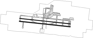
Taxiway locations
Parking locations
Nearby beacons
| code | identifier | dist | bearing | frequency |
|---|---|---|---|---|
| BTR | ISLAMABAD VOR/DME | 0.5 | 120° | 114.60 |
| RN | ISLAMABAD VOR/DME | 14.3 | 79° | 112.10 |
| RT | RAWALAKOT NDB | 50.8 | 73° | 295 |
| MF | MUZAFFARABAD NDB | 57.8 | 40° | 207 |
Departure and arrival routes
| SID end points | distance | outbound heading | |
|---|---|---|---|
| RW10 (ALL) | |||
| BOBA1N | 63mi | 13° | |
| INDE1E | 52mi | 152° | |
| BELK1G | 32mi | 204° | |
| DAMT1H | 58mi | 233° | |
| KALM1F | 41mi | 270° | |
| RW10L | |||
| BOBA1Q | 63mi | 13° | |
| INDE1G | 52mi | 152° | |
| BELK1J | 32mi | 204° | |
| DAMT1K | 58mi | 233° | |
| KALM1E | 41mi | 270° | |
| RW10R | |||
| BOBA2L | 63mi | 13° | |
| INDE2C | 52mi | 152° | |
| BELK2E | 32mi | 204° | |
| DAMT2F | 58mi | 233° | |
| KALM2C | 41mi | 270° | |
| RW28 (ALL) | |||
| BOBA1P | 63mi | 13° | |
| INDE1F | 52mi | 152° | |
| BELK1H | 32mi | 204° | |
| DAMT1J | 58mi | 233° | |
| KALM1G, KALM1H | 41mi | 270° | |
| RW28L | |||
| BOBA2M | 63mi | 13° | |
| INDE2D | 52mi | 152° | |
| BELK2F | 32mi | 204° | |
| DAMT2G | 58mi | 233° | |
| KALM2D | 41mi | 270° | |
| RW28R | |||
| BOBA1R | 63mi | 13° | |
| INDE1H | 52mi | 152° | |
| BELK1K | 32mi | 204° | |
| DAMT1L | 58mi | 233° | |
| KALM1J | 41mi | 270° | |
| STAR starting points | distance | inbound heading | |
|---|---|---|---|
| ALL | |||
| BELK1C, BELK1D | 32.0 | 24° | |
| DAMT1E, DAMT1D | 57.9 | 53° | |
| KALM1A, KALM1B | 41.1 | 90° | |
| BOBA1K, BOBA1J | 63.1 | 193° | |
| INDE1A, INDE1B | 51.5 | 332° | |
Instrument approach procedures
| runway | airway (heading) | route (dist, bearing) |
|---|---|---|
| RW10L | BOBAM (193°) | BOBAM IS412 (62mi, 177°) 12000ft IS414 (17mi, 253°) 8000ft SUMEB (12mi, 278°) 5000ft IS416 (6mi, 20°) 3700ft |
| RW10L | ISDUR (294°) | ISDUR 12000ft IS414 (18mi, 278°) 8000ft SUMEB (12mi, 278°) 5000ft IS416 (6mi, 20°) 3700ft |
| RW10L | KALMI (90°) | KALMI KIMUL (20mi, 90°) 10000ft IS415 (20mi, 90°) 9000ft IS414 (6mi, 195°) 8000ft SUMEB (12mi, 278°) 5000ft IS416 (6mi, 20°) 3700ft |
| RW10L | SUMEB (78°) | SUMEB 5000ft IS416 (6mi, 20°) 3700ft |
| RNAV | IS416 3700ft IS418 (4mi, 97°) 3700ft OPIS (8mi, 98°) 1786ft IS400 (2mi, 112°) (4552mi, 245°) 4500ft | |
| RW10R | BOBAM (193°) | BOBAM IS412 (62mi, 177°) 12000ft IS414 (17mi, 253°) 8000ft SUMEB (12mi, 278°) 5000ft IS416 (6mi, 20°) 3700ft |
| RW10R | ISDUR (294°) | ISDUR 12000ft IS414 (18mi, 278°) 8000ft SUMEB (12mi, 278°) 5000ft IS416 (6mi, 20°) 3700ft |
| RW10R | KALMI (90°) | KALMI KIMUL (20mi, 90°) 10000ft IS415 (20mi, 90°) 9000ft IS414 (6mi, 195°) 8000ft SUMEB (12mi, 278°) 5000ft IS416 (6mi, 20°) 3700ft |
| RW10R | SUMEB (78°) | SUMEB 5000ft IS416 (6mi, 20°) 3700ft |
| RNAV | IS416 3700ft IS417 (4mi, 99°) 3700ft OPIS (8mi, 97°) 1788ft IS400 (2mi, 112°) (4552mi, 245°) 4500ft | |
| RW28L | ISDUR (294°) | ISDUR 6000ft RENUX (9mi, 312°) 3700ft |
| RW28L | KALMI (90°) | KALMI KIMUL (20mi, 90°) 13000ft SUMEB (9mi, 110°) 11000ft IS414 (12mi, 98°) 8000ft ISBAX (11mi, 98°) 5000ft RENUX (5mi, 13°) 3700ft |
| RNAV | RENUX 3700ft IS411 (4mi, 279°) 3700ft OPIS (6mi, 281°) 1802ft IS409 (3mi, 275°) (4547mi, 245°) 3500ft (turn) 4500ft | |
| RW28R | ISDUR (294°) | ISDUR 6000ft RENUX (9mi, 312°) 3700ft |
| RW28R | KALMI (90°) | KALMI KIMUL (20mi, 90°) 13000ft SUMEB (9mi, 110°) 11000ft IS414 (12mi, 98°) 8000ft ISBAX (11mi, 98°) 5000ft RENUX (5mi, 13°) 3700ft |
| RNAV | RENUX 3700ft IS410 (4mi, 280°) 3700ft OPIS (6mi, 280°) 1805ft IS409 (3mi, 275°) (4547mi, 245°) 3500ft (turn) 4500ft |
Holding patterns
| STAR name | hold at | type | turn | heading* | altitude | leg | speed limit |
|---|---|---|---|---|---|---|---|
| BELK1C | ISDUR | VHF | left | 170 (350)° | 6000ft - 14000ft | DME 5.0mi | 220 |
| BELK1D | ISDUR | VHF | left | 170 (350)° | 6000ft - 14000ft | DME 5.0mi | 220 |
| BOBA1J | ISDUR | VHF | left | 170 (350)° | 6000ft - 14000ft | DME 5.0mi | 220 |
| BOBA1K | ISDUR | VHF | left | 170 (350)° | 6000ft - 14000ft | DME 5.0mi | 220 |
| DAMT1D | ISDUR | VHF | left | 170 (350)° | 6000ft - 14000ft | DME 5.0mi | 220 |
| DAMT1E | ISDUR | VHF | left | 170 (350)° | 6000ft - 14000ft | DME 5.0mi | 220 |
| INDE1A | ISDUR | VHF | left | 170 (350)° | 6000ft - 14000ft | DME 5.0mi | 220 |
| INDE1B | ISDUR | VHF | left | 170 (350)° | 6000ft - 14000ft | DME 5.0mi | 220 |
| KALM1A | ISDUR | VHF | left | 170 (350)° | 6000ft - 14000ft | DME 5.0mi | 220 |
| KALM1B | ISDUR | VHF | left | 170 (350)° | 6000ft - 14000ft | DME 5.0mi | 220 |
| *) magnetic outbound (inbound) holding course | |||||||
Disclaimer
The information on this website is not for real aviation. Use this data with the X-Plane flight simulator only! Data taken with kind consent from X-Plane 12 source code and data files. Content is subject to change without notice.