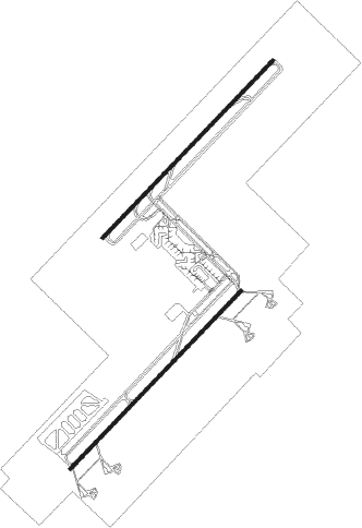
Damascus - Damascus Intl
Airport details
| Country | Syrian Arab Republic |
| State | Rif Dimashq Governorate |
| Region | OS |
| Airspace | Damascus Ctr |
| Municipality | Harran Al-Awamid Sudsitrict |
| Elevation | 2020ft (616m) |
| Timezone | GMT +2 |
| Coordinates | 33.41072, 36.51333 |
| Magnetic var | |
| Type | land |
| Available since | X-Plane v10.40 |
| ICAO code | OSDI |
| IATA code | DAM |
| FAA code | n/a |
Communication
| Damascus Intl ATIS | 128.225 |
| Damascus Intl Tower | 121.900 |
| Damascus Intl Tower | 118.075 |
| Damascus Intl Approach | 121.300 |
| Damascus Intl Approach | 120.000 |
Approach frequencies
| ILS-cat-II | RW05R | 111.1 | 18.00mi |
| ILS-cat-II | RW23R | 109.9 | 18.00mi |
| 3° GS | RW05R | 111.1 | 18.00mi |
| 3° GS | RW23R | 109.9 | 18.00mi |
Nearby beacons
| code | identifier | dist | bearing | frequency |
|---|---|---|---|---|
| DAM | DAMASCUS VOR/DME | 3.5 | 224° | 116 |
| ABD | ABYAD (DAMASCUS) NDB | 6.2 | 228° | 264 |
| DAL | DAMASCUS NDB | 6.3 | 49° | 342 |
| MEZ | MEZZEH (DAMASCUS) NDB | 15 | 285° | 358 |
| BAR | BAYSUR VOR | 52.5 | 291° | 113.90 |
| ROP | ROSH-PINA VOR/DME | 53.8 | 246° | 115.30 |
| KTN | KARIATAIN NDB | 60.7 | 41° | 372 |
| KTN | KARIATAIN VOR/DME | 61 | 43° | 117.70 |
| CAK | CHEKA VOR/DME | 67 | 318° | 116.20 |
Departure and arrival routes
| Transition altitude | 13000ft |
| Transition level | 15000ft |
| SID end points | distance | outbound heading | |
|---|---|---|---|
| RW05L | |||
| LEB2 | 51mi | 5° | |
| TAN22, TAN21 | 107mi | 88° | |
| SLF22, SLF21 | 83mi | 88° | |
| ABS22, ABS21 | 61mi | 89° | |
| BUS2 | 65mi | 175° | |
| RW05R | |||
| LEB2 | 51mi | 5° | |
| SLF22, SLF21 | 83mi | 88° | |
| TAN22, TAN21 | 107mi | 88° | |
| ABS22, ABS21 | 61mi | 89° | |
| BUS2 | 65mi | 175° | |
| RW23 (ALL) | |||
| LEB1 | 51mi | 5° | |
| SLF1, SLF2 | 83mi | 88° | |
| TAN1, TAN2 | 107mi | 88° | |
| ABS1, ABS2 | 61mi | 89° | |
| BUS1 | 65mi | 175° | |
| STAR starting points | distance | inbound heading | |
|---|---|---|---|
| ALL | |||
| LIMA1C | 51.4 | 185° | |
| TANG1C | 107.3 | 268° | |
| SIER1C | 94.6 | 278° | |
| BRAV1C | 64.9 | 355° | |
Instrument approach procedures
| runway | airway (heading) | route (dist, bearing) |
|---|---|---|
| RW23R | SOFIA (275°) | SOFIA SD523 (5mi, 319°) 5000ft SD524 (7mi, 309°) 4000ft SD525 (4mi, 233°) 3600ft |
| RNAV | SD525 3600ft OSDI (7mi, 229°) 2045ft (2875mi, 228°) 2420ft SD526 (2871mi, 48°) 5000ft SD526 (turn) |
Disclaimer
The information on this website is not for real aviation. Use this data with the X-Plane flight simulator only! Data taken with kind consent from X-Plane 12 source code and data files. Content is subject to change without notice.

