Farmington - Nemacolin
Airport details
| Country | United States of America |
| State | Pennsylvania |
| Region | K6 |
| Airspace | Cleveland Ctr |
| Municipality | Wharton Township |
| Elevation | 2008ft (612m) |
| Timezone | GMT -5 |
| Coordinates | 39.80563, -79.54893 |
| Magnetic var | |
| Type | land |
| Available since | X-Plane v10.40 |
| ICAO code | PA88 |
| IATA code | n/a |
| FAA code | PA88 |
Communication
| Nemacolin UNICOM | 123.000 |
Nearby Points of Interest:
Downer Tavern
-Kentuck Knob
-Wharton Furnace
-Hopwood-Miller Tavern
-Isaac Meason House
-Gallatin School
-Uniontown Downtown Historic District
-John S. Douglas House
-Mercy Chapel at Mill Run
-John P. Conn House
-Petersburg Tollhouse
-Adam Clarke Nutt Mansion
-Smock Historic District
-Connellsville Armory
-Carnegie Free Library
-United States Post Office
-Dr. J.C. McClenathan House and Office
-Colonial National Bank Building
-Connellsville Union Passenger Depot
-Cooper's Rock State Forest Superintendent's House and Garage
-Deffenbaugh Site
-Josiah Frost House
-Kaese Mill
-Reckart Mill
-James Drane House
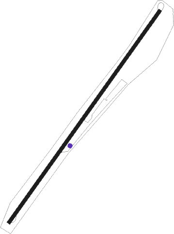
Runway info
| Runway 5 / 23 | ||
| length | 1140m (3740ft) | |
| bearing | 48° / 228° | |
| width | 15m (50ft) | |
| surface | asphalt | |
| displ threshold | 0m (0ft) / 119m (390ft) | |
Nearby beacons
| code | identifier | dist | bearing | frequency |
|---|---|---|---|---|
| VV | CAMOR (CONNELLSVILLE) NDB | 10.1 | 292° | 299 |
| IHD | INDIAN HEAD VORTAC | 13.4 | 48° | 108.20 |
| MGW | MORGANTOWN VOR/DME | 20.7 | 231° | 111.60 |
| GRV | DME | 25.2 | 109° | 112.30 |
| SYS | STOYSTOWN (SOMERSET) NDB | 33.6 | 66° | 209 |
| AGC | ALLEGHENY (PITTSBURGH) VOR/DME | 36.3 | 314° | 110 |
| ESL | KESSEL VOR/DME | 43.4 | 136° | 110.80 |
| JST | JOHNSTOWN VOR/DME | 44.9 | 54° | 113 |
| CKB | CLARKSBURG VOR/DME | 47 | 232° | 112.60 |
| MMJ | (PITTSBURGH) DME | 50.5 | 317° | 112 |
| RQY | RANDOLPH CO. (ELKINS) NDB | 56.6 | 199° | 284 |
| REC | REVLOC VOR/DME | 57.7 | 47° | 110.60 |
| EKN | ELKINS VORTAC | 59.3 | 212° | 114.20 |
Disclaimer
The information on this website is not for real aviation. Use this data with the X-Plane flight simulator only! Data taken with kind consent from X-Plane 12 source code and data files. Content is subject to change without notice.