Kodiak
Airport details
| Country | United States of America |
| State | Alaska |
| Region | PA |
| Municipality | Kodiak Island |
| Elevation | 78ft (24m) |
| Timezone | GMT -9 |
| Coordinates | 57.73771, -152.50916 |
| Magnetic var | |
| Type | land |
| Available since | X-Plane v10.40 |
| ICAO code | PADQ |
| IATA code | ADQ |
| FAA code | ADQ |
Communication
| Kodiak ATIS | 134.450 |
| Kodiak CTAF | 119.800 |
| Kodiak UNICOM | 122.800 |
| Kodiak Ground Control | 121.900 |
| Kodiak Tower | 119.800 |
| Kodiak ANCHORAGE CNTR | 125.100 |
Approach frequencies
| ILS-cat-I | RW26 | 110.9 | 18.00mi |
| 2° GS | RW26 | 110.9 | 18.00mi |
Nearby Points of Interest:
Coast Guard Base Kodiak
-Holy Resurrection Church
-Nativity of Holy Theolokos Church
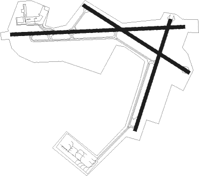
Runway info
Runway 8 / 26  | ||
| length | 2289m (7510ft) | |
| bearing | 91° / 271° | |
| width | 46m (150ft) | |
| surface | asphalt | |
| displ threshold | 347m (1138ft) / 0m (0ft) | |
| blast zone | 0m (0ft) / 183m (600ft) | |
| Runway 11 / 29 | ||
| length | 1642m (5387ft) | |
| bearing | 112° / 292° | |
| width | 46m (150ft) | |
| surface | asphalt | |
| displ threshold | 134m (440ft) / 170m (558ft) | |
| Runway 1 / 19 | ||
| length | 1524m (5000ft) | |
| bearing | 38° / 218° | |
| width | 46m (150ft) | |
| surface | asphalt | |
| blast zone | 59m (194ft) / 80m (262ft) | |
Nearby beacons
| code | identifier | dist | bearing | frequency |
|---|---|---|---|---|
| ODK | KODIAK VOR/DME | 5.8 | 78° | 117.10 |
| RWO | WOODY ISLAND (KODIAK) NDB | 6.3 | 79° | 394 |
Instrument approach procedures
| runway | airway (heading) | route (dist, bearing) |
|---|---|---|
| RW26 | FEGEN (243°) | FEGEN RUGVE (9mi, 182°) 4000ft |
| RW26 | HINBU (273°) | HINBU RUGVE (9mi, 305°) 4000ft |
| RNAV | RUGVE 4000ft MATOE (7mi, 261°) 2500ft CADUL (6mi, 261°) 576ft (7100mi, 111°) 576ft HINBU (7094mi, 291°) 4000ft HINBU (turn) 4000ft |
Disclaimer
The information on this website is not for real aviation. Use this data with the X-Plane flight simulator only! Data taken with kind consent from X-Plane 12 source code and data files. Content is subject to change without notice.