Kapolei - Kalaeloa
Airport details
| Country | United States of America |
| State | Hawaii |
| Region | PH |
| Airspace | Honolulu Control Facility Ctr |
| Municipality | Kapolei |
| Elevation | 20ft (6m) |
| Timezone | GMT -10 |
| Coordinates | 21.30264, -158.06380 |
| Magnetic var | |
| Type | land |
| Available since | X-Plane v10.40 |
| ICAO code | PHJR |
| IATA code | JRF |
| FAA code | JRF |
Communication
| Kalaeloa ATIS | 119.800 |
| Kalaeloa CTAF | 132.600 |
| Kalaeloa Clearance DEL | 121.700 |
| Kalaeloa Ground Control | 123.800 |
| Kalaeloa Tower | 132.600 |
| Kalaeloa HONOLULU Approach/Departure | 118.300 |
Nearby Points of Interest:
Honouliuli Internment Camp
-Naval Station Pearl Harbor
-USS Arizona Memorial
-Palm Circle
-Kaumakapili Church
-Kakaako Pumping Station
-C. Brewer Building
-Joseph W. Podmore Building
-Merchant Street Historic District
-Kamehameha V Post Office
-Kapuāiwa Building
-YWCA Building
-Aliiolani Hale
-Royal Brewery
-Hawaii State Library
-Linekona School
-Georges de S. Canavarro House
-Kukaniloko Birth Site
-H. Alexander Walker Residence
-Thomas Alexander Burningham House
-Alfred Hocking House
-Koʻolau Range
-Sacred Heart Church-Punahou
-Lihiwai
-George D. Oakley House
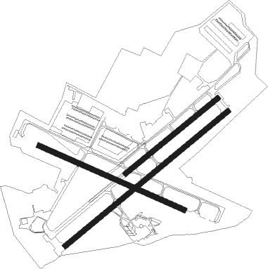
Runway info
Runway 4R / 22L  | ||
| length | 2441m (8009ft) | |
| bearing | 57° / 237° | |
| width | 61m (200ft) | |
| surface | asphalt | |
| blast zone | 0m (0ft) / 55m (180ft) | |
| Runway 11 / 29 | ||
| length | 1830m (6004ft) | |
| bearing | 117° / 297° | |
| width | 61m (200ft) | |
| surface | asphalt | |
| blast zone | 255m (837ft) / 255m (837ft) | |
| Runway 4L / 22R | ||
| length | 1371m (4498ft) | |
| bearing | 57° / 237° | |
| width | 61m (200ft) | |
| surface | asphalt | |
Nearby beacons
| code | identifier | dist | bearing | frequency |
|---|---|---|---|---|
| HN | EWABE (HONOLULU) NDB | 1.5 | 34° | 242 |
| HNL | HONOLULU VORTAC | 7.4 | 88° | 114.80 |
| NGF | KANEOHE BAY (MOKAPU) TACAN | 19.4 | 63° | 114.60 |
| NGF | KANEOHE BAY (MOKAPU) NDB | 19.5 | 64° | 265 |
| CKH | KOKO HEAD VORTAC | 20.3 | 96° | 113.90 |
| MKK | MOLOKAI (KAUNAKAKAI) VORTAC | 51.1 | 100° | 116.10 |
Departure and arrival routes
| Transition altitude | 18000ft |
| Transition level | 18000ft |
| SID end points | distance | outbound heading | |
|---|---|---|---|
| RW11 | |||
| JELIE1 | 186mi | 14° | |
| RW22L | |||
| JELIE1 | 186mi | 14° | |
Instrument approach procedures
| runway | airway (heading) | route (dist, bearing) |
|---|---|---|
| RW04R | HNL (268°) | HNL SIMSN (17mi, 251°) 2300ft SIMSN (turn) 2000ft |
| RW04R | KEOLA (89°) | KEOLA GECKO (12mi, 120°) 4000ft SIMSN (5mi, 80°) 2000ft |
| RNAV | SIMSN 2000ft HIKAG (5mi, 57°) 1500ft PHJR (5mi, 61°) 66ft (8996mi, 98°) 430ft GECKO (9011mi, 278°) 3000ft GECKO (turn) |
Disclaimer
The information on this website is not for real aviation. Use this data with the X-Plane flight simulator only! Data taken with kind consent from X-Plane 12 source code and data files. Content is subject to change without notice.