Buenos Aires - Ministro Pistarini Intl
Airport details
| Country | Argentina |
| State | Buenos Aires |
| Region | SA |
| Airspace | Ezeiza Ctr |
| Municipality | Aeropuerto Internacional Ezeiza |
| Elevation | 64ft (20m) |
| Timezone | GMT -3 |
| Coordinates | -34.82222, -58.53583 |
| Magnetic var | |
| Type | land |
| Available since | X-Plane v10.30 |
| ICAO code | SAEZ |
| IATA code | EZE |
| FAA code | n/a |
Communication
Approach frequencies
| ILS-cat-III | RW11 | 110.1 | 18.00mi |
| ILS-cat-I | RW35 | 108.7 | 18.00mi |
| 3° GS | RW35 | 108.7 | 18.00mi |
| 3° GS | RW11 | 110.1 | 18.00mi |
Nearby Points of Interest:
Ciudad Evita
-Biblioteca Popular Antonio Mentruyt
-Administración de los Mataderos
-Olimpo
-Puente Valentín Alsina
-Casa Marcó del Pont
-Plaza Primera Junta
-Depósito de Gravitación de Villa Devoto
-Café El Estaño 1880
-Mariano Acosta school
-Joaquín V. González Public Library
-Café San Bernardo
-Virrey Cevallos
-Café de los Angelitos
-Palacio Dassen
-Bar El Federal
-plaza Dorrego
-El Club Atlético
-Congressional Plaza
-Confederación General Económica
-El Gato Negro
-puente de Marquez
-Avenida de Mayo
-Librería de Ávila
-Palacio de la Legislatura de la Ciudad de Buenos Aires
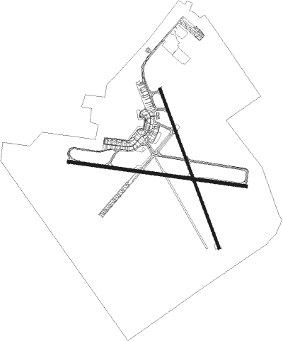
Runway info
Runway 11 / 29  | ||
| length | 3291m (10797ft) | |
| bearing | 100° / 280° | |
| width | 61m (200ft) | |
| surface | asphalt | |
| Runway 17 / 35 | ||
| length | 3117m (10226ft) | |
| bearing | 161° / 341° | |
| width | 46m (151ft) | |
| surface | asphalt | |
| displ threshold | 0m (0ft) / 301m (988ft) | |
Nearby beacons
| code | identifier | dist | bearing | frequency |
|---|---|---|---|---|
| EZE | EZEIZA VOR/DME | 0.1 | 164° | 116.50 |
| C | EZEIZA INTL MINISTRO PISTARINI NDB | 1.4 | 280° | 305 |
| OA | EZEIZA INTL MINISTRO PISTARINI NDB | 4.3 | 156° | 270 |
| OC | EZEIZA INTL MINISTRO PISTARINI NDB | 4.9 | 280° | 330 |
| PAL | EL PALOMAR (BUENOS AIRES) VOR/DME | 13.2 | 340° | 115.20 |
| ILM | QUILMES NDB | 16 | 69° | 210 |
| N | JORGE NEWBERY AEROPARQUE(BUENO NDB | 16.4 | 35° | 375 |
| P | JORGE NEWBERY AEROPARQUE(BUENO NDB | 17.2 | 19° | 280 |
| ENO | MARIANO MORENO VOR/DME | 20 | 316° | 112.90 |
| FDO | SAN FERNANDO VOR/DME | 22.3 | 353° | 114.40 |
| PTA | LA PLATA NDB | 32.6 | 103° | 250 |
| PTA | LA PLATA VOR | 32.7 | 104° | 113.70 |
| GBE | GEN BELGRANO (BUENOS AIRE VOR | 55.8 | 176° | 115.60 |
| SNT | SAN ANTONIO DE ARECO VOR/DME | 57.4 | 304° | 117.70 |
Departure and arrival routes
| Transition altitude | 3000ft |
| SID end points | distance | outbound heading | |
|---|---|---|---|
| RW11 | |||
| PTA6B | 55mi | 127° | |
| GBE6 | 56mi | 176° | |
| TORUL1 | 55mi | 276° | |
| ATOV2A | 55mi | 321° | |
| BIVA2A | 55mi | 334° | |
| LAND2A | 55mi | 358° | |
| RW17 | |||
| PTA6A | 55mi | 127° | |
| GBE6 | 56mi | 176° | |
| TORUL1 | 55mi | 276° | |
| ATOV2A | 55mi | 321° | |
| BIVA2A | 55mi | 334° | |
| LAND2A | 55mi | 358° | |
| RW29 | |||
| PTA6A | 55mi | 127° | |
| GBE6 | 56mi | 176° | |
| TORUL1 | 55mi | 276° | |
| ATOV2A | 55mi | 321° | |
| BIVA2A | 55mi | 334° | |
| LAND2A | 55mi | 358° | |
| RW35 | |||
| PTA6A | 55mi | 127° | |
| GBE6 | 56mi | 176° | |
| TORUL1 | 55mi | 276° | |
| ATOV2A | 55mi | 321° | |
| BIVA2A | 55mi | 334° | |
| LAND2A | 55mi | 358° | |
| STAR starting points | distance | inbound heading | |
|---|---|---|---|
| RW11 | |||
| VALO7A | 55.2 | 52° | |
| ASAD6A | 55.0 | 79° | |
| SNT6A | 57.4 | 124° | |
| PAGO6A | 54.8 | 168° | |
| KUKE6A | 41.5 | 206° | |
| PAPI6A | 35.9 | 233° | |
| UGIM6A | 72.1 | 276° | |
| KOVU6A | 54.8 | 290° | |
| TENI6A | 55.2 | 316° | |
| GBE6A | 55.8 | 356° | |
| RW35 | |||
| VALO6B | 55.2 | 52° | |
| ASAD6B | 55.0 | 79° | |
| SNT6B | 57.4 | 124° | |
| PAGO6B | 54.8 | 168° | |
| KUKE6B | 41.5 | 206° | |
| PAPI6B | 35.9 | 233° | |
| UGIM6B | 72.1 | 276° | |
| KOVU6B | 54.8 | 290° | |
| TENI6B | 55.2 | 316° | |
| GBE6B | 55.8 | 356° | |
Instrument approach procedures
| runway | airway (heading) | route (dist, bearing) |
|---|---|---|
| RW11 | ARSOT (100°) | ARSOT IMBOD (7mi, 99°) 2500ft |
| RNAV | IMBOD 2500ft VUPAN (5mi, 100°) 1700ft SAEZ (6mi, 100°) 118ft (3881mi, 59°) 1000ft NEVLO (3875mi, 239°) 3000ft NEVLO (turn) 3000ft | |
| RW17 | ARSOT (100°) | ARSOT EZ179 (10mi, 88°) 2800ft KOPRO (3mi, 79°) 2000ft EZ177 (3mi, 79°) 1400ft |
| RNAV | EZ177 1400ft SURLI (2mi, 144°) 1100ft EZ176 (1mi, 161°) 730ft SAEZ (3mi, 169°) 113ft EZ175 (2mi, 152°) GESTA (14mi, 162°) ARSOT (29mi, 305°) 3000ft ARSOT (turn) 3000ft | |
| RW29 | NEVLO (306°) | NEVLO 3000ft PAPAP (6mi, 9°) 2500ft |
| RW29 | UPOMA (277°) | UPOMA 3000ft PAPAP (5mi, 270°) 2500ft |
| RNAV | PAPAP 2500ft OPLOM (5mi, 280°) 1700ft SAEZ (6mi, 280°) 116ft ARSOT (18mi, 280°) 3000ft ARSOT (turn) 3000ft | |
| RW35 | GESTA (341°) | GESTA MOSGI (5mi, 345°) 2500ft |
| RNAV | MOSGI 2500ft POSRA (5mi, 341°) 1750ft SAEZ (6mi, 337°) 117ft EZ684 (1mi, 358°) ARSOT (18mi, 276°) 3000ft ARSOT (turn) 3000ft |
Holding patterns
| STAR name | hold at | type | turn | heading* | altitude | leg | speed limit |
|---|---|---|---|---|---|---|---|
| ASAD6A | ARSOT | VHF | right | 290 (110)° | > 5000ft | 1.0min timed | 210 |
| ASAD6B | GESTA | VHF | right | 188 (8)° | > 5000ft | DME 4.0mi | 210 |
| GBE6A | ARSOT | VHF | right | 290 (110)° | > 5000ft | 1.0min timed | 210 |
| GBE6B | GESTA | VHF | right | 188 (8)° | > 5000ft | DME 4.0mi | 210 |
| KOVU6A | PTA | NDB | right | 97 (277)° | > 12000ft | 1.0min timed | ICAO rules |
| KOVU6B | GESTA | VHF | right | 188 (8)° | > 5000ft | DME 4.0mi | 210 |
| KOVU6B | PTA | NDB | right | 97 (277)° | > 12000ft | 1.0min timed | ICAO rules |
| PAGO6A | ARSOT | VHF | right | 290 (110)° | > 5000ft | 1.0min timed | 210 |
| PAGO6B | VANAR | VHF | right | 319 (139)° | > 5000ft | 1.0min timed | 210 |
| SNT6A | ARSOT | VHF | right | 290 (110)° | > 5000ft | 1.0min timed | 210 |
| SNT6B | VANAR | VHF | right | 319 (139)° | > 5000ft | 1.0min timed | 210 |
| TENI6A | PTA | NDB | right | 97 (277)° | > 12000ft | 1.0min timed | ICAO rules |
| TENI6B | GESTA | VHF | right | 188 (8)° | > 5000ft | DME 4.0mi | 210 |
| TENI6B | PTA | NDB | right | 97 (277)° | > 12000ft | 1.0min timed | ICAO rules |
| UGIM6A | PTA | NDB | right | 97 (277)° | > 12000ft | 1.0min timed | ICAO rules |
| UGIM6B | GESTA | VHF | right | 188 (8)° | > 5000ft | DME 4.0mi | 210 |
| UGIM6B | PTA | NDB | right | 97 (277)° | > 12000ft | 1.0min timed | ICAO rules |
| VALO6B | GESTA | VHF | right | 188 (8)° | > 5000ft | DME 4.0mi | 210 |
| *) magnetic outbound (inbound) holding course | |||||||
Disclaimer
The information on this website is not for real aviation. Use this data with the X-Plane flight simulator only! Data taken with kind consent from X-Plane 12 source code and data files. Content is subject to change without notice.