Anápolis - Base Aerea
Airport details
| Country | Brazil |
| State | Goiás |
| Region | SB |
| Airspace | Brasilia Ctr |
| Municipality | Anápolis |
| Elevation | 3728ft (1136m) |
| Timezone | GMT -3 |
| Coordinates | -16.23861, -48.97222 |
| Magnetic var | |
| Type | land |
| Available since | X-Plane v10.40 |
| ICAO code | SBAN |
| IATA code | APS |
| FAA code | n/a |
Communication
| Base Aerea Ground Control | 121.900 |
| Base Aerea Tower | 121.250 |
| Base Aerea Tower | 118.300 |
| Base Aerea Approach | 119.150 |
| Base Aerea Approach | 120.550 |
| Base Aerea Approach | 133.000 |
| Base Aerea Approach | 129.450 |
Approach frequencies
| ILS-cat-I | RW24R | 111.1 | 18.00mi |
| 2.6° GS | RW24R | 111.1 | 18.00mi |
Nearby Points of Interest:
House of the Babilónia Estate
-Praça Cívica
-Parish Church of Our Lady of the Rosary
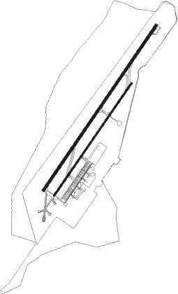
Runway info
Runway 06L / 24R  | ||
| length | 3311m (10863ft) | |
| bearing | 40° / 220° | |
| width | 45m (148ft) | |
| surface | asphalt | |
| blast zone | 255m (837ft) / 255m (837ft) | |
| Runway 06R / 24L | ||
| length | 2268m (7441ft) | |
| bearing | 40° / 220° | |
| width | 23m (75ft) | |
| surface | asphalt | |
| displ threshold | 7m (23ft) / 10m (33ft) | |
Nearby beacons
| code | identifier | dist | bearing | frequency |
|---|---|---|---|---|
| APO | ANAPOLIS VOR/DME | 0.5 | 225° | 116.80 |
| GNV | GOIANIA VOR/DME | 27.8 | 211° | 115.90 |
| SBG | SANTA BARBARA (ANAPOLIS) NDB | 46.5 | 245° | 230 |
| BSI | BRASILIA VOR/DME | 59.1 | 69° | 116.30 |
Departure and arrival routes
| Transition altitude | 7000ft |
| SID end points | distance | outbound heading | |
|---|---|---|---|
| RW06L | |||
| OMNI | 10mi | 40° | |
| DOGP2A | 24mi | 335° | |
| RW24R | |||
| OMNI | 10mi | 40° | |
| PAJE1A | 22mi | 90° | |
| DODM2A | 24mi | 335° | |
Instrument approach procedures
| runway | airway (heading) | route (dist, bearing) |
|---|---|---|
| RW06LZ | AN001 (65°) | AN001 7000ft AN004 (6mi, 109°) 5400ft |
| RW06LZ | AN002 (40°) | AN002 7000ft AN004 (5mi, 40°) 5400ft |
| RW06LZ | AN003 (15°) | AN003 7000ft AN004 (6mi, 328°) 5400ft |
| RNAV | AN004 5400ft AN006 (5mi, 40°) 5380ft SBAN (5mi, 41°) 3781ft AN008 (17mi, 40°) 7000ft AN008 (turn) 7000ft | |
| RW24RY | AN007 (242°) | AN007 7000ft AN011 (6mi, 289°) 5400ft |
| RW24RY | AN008 (220°) | AN008 7000ft AN011 (5mi, 220°) 5400ft |
| RW24RY | AN009 (197°) | AN009 7000ft AN011 (6mi, 148°) 5400ft |
| RNAV | AN011 5400ft AN016 (5mi, 220°) 5300ft SBAN (7mi, 220°) 3706ft AN002 (15mi, 220°) 7000ft AN002 (turn) 7000ft |
Disclaimer
The information on this website is not for real aviation. Use this data with the X-Plane flight simulator only! Data taken with kind consent from X-Plane 12 source code and data files. Content is subject to change without notice.