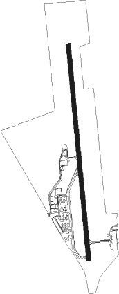
Guaratinguetá - Guaratingueta
Airport details
| Country | Brazil |
| State | São Paulo |
| Region | SB |
| Airspace | Curitiba Ctr |
| Municipality | Guaratinguetá |
| Elevation | 1761ft (537m) |
| Timezone | GMT -3 |
| Coordinates | -22.79716, -45.20321 |
| Magnetic var | |
| Type | land |
| Available since | X-Plane v10.40 |
| ICAO code | SBGW |
| IATA code | GUJ |
| FAA code | n/a |
Communication
| Guaratingueta GUARA Tower | 125.900 |
| Guaratingueta GUARA Tower | 122.800 |
| Guaratingueta GUARA Approach | 122.800 |
Nearby Points of Interest:
Casa Térrea à Rua Frei Galvão
-Estação Ferroviária de Cachoeira Paulista
-Palacete Palmeira
-Sobrado do Capitão Silveira
-Sobrado na Rua Nove de Julho, 136
-Fazenda Pau d'Alho
-Santa Casa de Misericórdia de Paraty
Nearby beacons
| code | identifier | dist | bearing | frequency |
|---|---|---|---|---|
| GGT | GUARATINGUETA NDB | 0.8 | 307° | 275 |
| PND | VIBASA (PINDAMONHANGABA) NDB | 9.9 | 241° | 205 |
| TAU | TAUBATE VOR/DME | 22.3 | 232° | 112.60 |
| TBE | TAUBATE NDB | 22.8 | 232° | 430 |
| SCP | SAO JOSE (SAO JOSE DOS CA VOR/DME | 44.7 | 236° | 115.40 |
Departure and arrival routes
| Transition altitude | 7000ft |
| SID end points | distance | outbound heading | |
|---|---|---|---|
| RW02 | |||
| IMDA1A | 40mi | 125° | |
| GGT3B, SCP1B | 45mi | 236° | |
| OMNI | 46mi | 244° | |
| RW20 | |||
| IMDA1B, IMDA1C | 40mi | 125° | |
| SCP1A, SCP1C | 45mi | 236° | |
| OMNI | 46mi | 244° | |
Instrument approach procedures
| runway | airway (heading) | route (dist, bearing) |
|---|---|---|
| RW20-A | OPTOD (244°) | OPTOD 7000ft GW018 (5mi, 302°) 4700ft |
| RNAV | GW018 4700ft GW019 (5mi, 242°) 3260ft GW021 (3mi, 223°) 2400ft (2970mi, 63°) 4000ft OPTOD (2959mi, 243°) 7000ft OPTOD (turn) 7000ft | |
| RWNVB | OPTOD (244°) | OPTOD 7000ft GW018 (5mi, 302°) 4700ft |
| RNAV | GW018 4700ft GW019 (5mi, 242°) 3890ft GW021 (3mi, 223°) 2940ft GW022 (2mi, 223°) 2400ft (2971mi, 63°) 4000ft OPTOD (2959mi, 243°) 7000ft OPTOD (turn) 7000ft |
Disclaimer
The information on this website is not for real aviation. Use this data with the X-Plane flight simulator only! Data taken with kind consent from X-Plane 12 source code and data files. Content is subject to change without notice.