Rionegro - Jose Maria Cordova
Airport details
| Country | Colombia |
| State | Antioquia |
| Region | SK |
| Airspace | Bogota Ctr |
| Municipality | Rionegro |
| Elevation | 7023ft (2141m) |
| Timezone | GMT -5 |
| Coordinates | 6.16851, -75.42209 |
| Magnetic var | |
| Type | land |
| Available since | X-Plane v10.40 |
| ICAO code | SKRG |
| IATA code | MDE |
| FAA code | n/a |
Communication
| Jose Maria Cordova ATIS | 115.100 |
| Jose Maria Cordova Ground Control | 121.900 |
| Jose Maria Cordova Tower | 118.600 |
| Jose Maria Cordova MEDELLIN South Approach | 121.100 |
| Jose Maria Cordova MEDELLIN North Approach | 126.100 |
Approach frequencies
| ILS-cat-I | RW01 | 110.9 | 18.00mi |
| 3° GS | RW01 | 110.9 | 18.00mi |
Nearby Points of Interest:
Basilica of Our Lady of Candelaria
-Enrique Olaya Herrera Airport
-Cerro El Volador
-Capilla de Nuestra Señora de la Candelaria
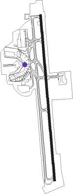
Runway info
| Runway 01 / 19 | ||
| length | 3463m (11362ft) | |
| bearing | 360° / 180° | |
| width | 45m (148ft) | |
| surface | asphalt | |
| blast zone | 30m (98ft) / 30m (98ft) | |
Nearby beacons
| code | identifier | dist | bearing | frequency |
|---|---|---|---|---|
| MRN | MARINILLA (RIONEGRO) VOR/DME | 5.8 | 85° | 113 |
| RNG | RIONEGRO (MEDELLIN) VOR/DME | 11.2 | 179° | 115.10 |
| PAL | PALANQUERO (PUERTO SALGAR VOR/DME | 61.1 | 132° | 114.20 |
| MQU | MARIQUITA VOR/DME | 65.1 | 153° | 116.10 |
| OTU | OTU VOR/DME | 66.5 | 40° | 115.40 |
Departure and arrival routes
| Transition altitude | 18000ft |
| Transition level | 19000ft |
| SID end points | distance | outbound heading | |
|---|---|---|---|
| RW01 | |||
| LATI2A, LATI1B | 51mi | 2° | |
| BIVI1B, BIVI3A | 53mi | 15° | |
| OTU1C | 67mi | 40° | |
| DIPR1C | 59mi | 63° | |
| MUGO2B | 29mi | 131° | |
| ISVA2B | 34mi | 148° | |
| RNG2B, MRN1C | 11mi | 179° | |
| DABI2B | 25mi | 246° | |
| KOTI2A | 53mi | 294° | |
| IBDA1A, OPME2C | 47mi | 317° | |
| TEDO1B | 52mi | 351° | |
| BUTA2A | 101mi | 359° | |
| KORB1C | 51mi | 359° | |
| RW19 | |||
| MRN5B | 67mi | 40° | |
| ISVO1B | 47mi | 194° | |
| VULR1A | 42mi | 215° | |
| DABI1C | 25mi | 246° | |
| STAR starting points | distance | inbound heading | |
|---|---|---|---|
| RW01 | |||
| ISVO2A | 47.3 | 14° | |
| MATR5A | 64.0 | 16° | |
| ARTU2A | 28.7 | 54° | |
| NENE1A | 23.8 | 102° | |
| OPME2A | 46.5 | 137° | |
| ISPA1A | 15.4 | 152° | |
| AKPE2C | 111.7 | 168° | |
| TEDO1A | 51.8 | 171° | |
| KORB1A | 51.1 | 179° | |
| LATI1C | 51.2 | 182° | |
| BIVI1C | 52.9 | 195° | |
| OTU1A | 66.5 | 220° | |
| AKSE1A | 20.6 | 228° | |
| DIPR1B | 58.7 | 243° | |
| RENO1B, RENO2A | 37.4 | 336° | |
| NIRS3A, NIRS1C | 49.6 | 358° | |
| RNG3C | 11.2 | 359° | |
Instrument approach procedures
| runway | airway (heading) | route (dist, bearing) |
|---|---|---|
| RW01 | DONTU (22°) | DONTU 12000ft GEMLI (7mi, 90°) 12000ft |
| RW01 | OGMES (0°) | OGMES 13000ft GEMLI (6mi, 0°) 12000ft |
| RW01 | VUKUL (338°) | VUKUL 12000ft GEMLI (7mi, 270°) 12000ft |
| RNAV | GEMLI 12000ft KUGNU (8mi, 360°) 9700ft POTGA (5mi, 360°) 8270ft SKRG (5mi, 0°) 7017ft KOXEV (2mi, 358°) 8100ft MRN (6mi, 106°) 10300ft MRN (turn) 11000ft |
Holding patterns
| STAR name | hold at | type | turn | heading* | altitude | leg | speed limit |
|---|---|---|---|---|---|---|---|
| AKPE2C | ISPAS | VHF | left | 6 (186)° | 13000ft - 14000ft | 1.0min timed | 230 |
| AKSE1A | AKSER | VHF | left | 42 (222)° | > 12000ft | 1.0min timed | 230 |
| ARTU2A | ARTUX | VHF | left | 264 (84)° | > 15000ft | 1.5min timed | 230 |
| BIVI1C | AKSER | VHF | left | 42 (222)° | > 12000ft | 1.0min timed | 230 |
| DIPR1B | AKSER | VHF | left | 42 (222)° | > 12000ft | 1.0min timed | 230 |
| ISPA1A | ISPAS | VHF | left | 6 (186)° | 13000ft - 14000ft | 1.0min timed | 230 |
| ISVO2A | ISVON | VHF | left | 206 (26)° | 13000ft - 14000ft | 1.0min timed | 230 |
| KORB1A | ISPAS | VHF | left | 6 (186)° | 13000ft - 14000ft | 1.0min timed | 230 |
| LATI1C | AKSER | VHF | left | 42 (222)° | > 12000ft | 1.0min timed | 230 |
| MATR5A | ISVON | VHF | left | 206 (26)° | 13000ft - 14000ft | 1.0min timed | 230 |
| MRN1D | MRN | NDB | left | 5 (185)° | > 11000ft | 1.0min timed | 230 |
| MRN8A | MRN | NDB | left | 5 (185)° | > 11000ft | 1.0min timed | 230 |
| MRN8A | RNG | NDB | left | 182 (2)° | 12000ft - 19500ft | 1.0min timed | 250 |
| OPME2A | ISPAS | VHF | left | 6 (186)° | 13000ft - 14000ft | 1.0min timed | 230 |
| OPME2A | OPMEL | VHF | right | 332 (152)° | > 15000ft | 1.5min timed | 230 |
| OTU1A | AKSER | VHF | left | 42 (222)° | > 12000ft | 1.0min timed | 230 |
| RNG3C | RNG | NDB | left | 182 (2)° | 12000ft - 19500ft | 1.0min timed | 250 |
| TEDO1A | ISPAS | VHF | left | 6 (186)° | 13000ft - 14000ft | 1.0min timed | 230 |
| *) magnetic outbound (inbound) holding course | |||||||
Disclaimer
The information on this website is not for real aviation. Use this data with the X-Plane flight simulator only! Data taken with kind consent from X-Plane 12 source code and data files. Content is subject to change without notice.