Montevideo - Montevideo Carrasco Intl
Airport details
| Country | Uruguay |
| State | Canelones |
| Region | SU |
| Airspace | Montevideo Ctr |
| Municipality | Municipio de Paso Carrasco |
| Elevation | 104ft (32m) |
| Timezone | GMT -3 |
| Coordinates | -34.83389, -56.02806 |
| Magnetic var | |
| Type | land |
| Available since | X-Plane v10.40 |
| ICAO code | SUMU |
| IATA code | MVD |
| FAA code | n/a |
Communication
| Montevideo Carrasco Intl Tower | 118.100 |
| Montevideo Carrasco Intl Tower | 121.800 |
| Montevideo Carrasco Intl Approach | 119.200 |
| Montevideo Carrasco Intl Approach | 120.200 |
| Montevideo Carrasco Intl Departure | 120.200 |
| Montevideo Carrasco Intl Departure | 119.200 |
Approach frequencies
| ILS-cat-I | RW24 | 109.9 | 18.00mi |
| ILS-cat-I | RW19 | 111.1 | 18.00mi |
| 3° GS | RW24 | 109.9 | 18.00mi |
| 3° GS | RW19 | 111.1 | 18.00mi |
Nearby Points of Interest:
Carrasco International Airport
-Hospital de Clínicas
-Italian Hospital of Montevideo
-Pintura mural en pared de Expo-Feria de Pando
-Reus al Norte
-Hospital Vilardebó
-Universidad de la República - Udelar
-National Library of Uruguay
-Peñarol
-Parque de las Instrucciones del Año XIII
-Molino Harinero del Este
-El Hotel del Prado
-Casa de Augusto Pérsico, Montevideo
-Mercado de la Abundancia
-Palacio Santos
-Palacio Piria
-Teatro Victoria Hall
-Rambla of Montevideo
-Edificio Rex
-Edificio Lapido
-Edificio Jockey Club
-Edificio del Ministerio de Industria y Energía - Palacio Correa
-Monumento a Artigas
-Estévez Palace
-Centro Cultural de España en Montevideo
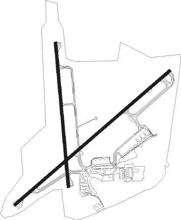
Runway info
Runway 01 / 19  | ||
| length | 2256m (7402ft) | |
| bearing | 359° / 179° | |
| width | 45m (148ft) | |
| surface | asphalt | |
| blast zone | 62m (203ft) / 58m (190ft) | |
| Runway 06 / 24 | ||
| length | 3203m (10509ft) | |
| bearing | 59° / 239° | |
| width | 45m (148ft) | |
| surface | asphalt | |
| displ threshold | 348m (1142ft) / 147m (482ft) | |
| blast zone | 61m (200ft) / 60m (197ft) | |
Nearby beacons
| code | identifier | dist | bearing | frequency |
|---|---|---|---|---|
| CRR | CARRASCO (MONTEVIDEO) VOR/DME | 0.1 | 68° | 116.90 |
| CRO | CARRASCO (MONTEVIDEO) NDB | 1 | 352° | 305 |
| AR | CARRASCO (MONTEVIDEO) NDB | 1.2 | 64° | 260 |
| CAR | CARRASCO (MONTEVIDEO) NDB | 3.9 | 2° | 380 |
| CA | CARRASCO (MONTEVIDEO) NDB | 5.1 | 60° | 280 |
| ASI | ADAMI (MONTEVIDEO) NDB | 11.8 | 281° | 395 |
| LS | CAPITAN CURBELO (MALDONADO) NDB | 45.7 | 92° | 239 |
| LDS | CURBELO (MALDONADO) VOR/DME | 46.1 | 91° | 117.60 |
Departure and arrival routes
| Transition altitude | 3000ft |
| SID end points | distance | outbound heading | |
|---|---|---|---|
| RW06 | |||
| AKPO1B | 188mi | 46° | |
| DAGU1C, DAGU1A | 43mi | 260° | |
| CRR1R | 30mi | 305° | |
| RW24 | |||
| DAGU1M | 43mi | 260° | |
| NIMB1M | 30mi | 305° | |
| MONS2M | 30mi | 342° | |
| STAR starting points | distance | inbound heading | |
|---|---|---|---|
| RW06 | |||
| DARK1C | 30.0 | 26° | |
| TOKA1C, TOKA1A | 34.0 | 94° | |
| 06ALFA | 73.8 | 95° | |
| KOSP1C | 31.6 | 102° | |
| NIMB1C | 29.9 | 125° | |
| DRAC1C | 30.0 | 140° | |
| GUVI1C | 30.0 | 149° | |
| MONS1C | 30.0 | 162° | |
| REGO1C | 30.1 | 182° | |
| TELA1C | 34.6 | 217° | |
| LDS1C | 46.1 | 271° | |
| RW24 | |||
| DARK1G | 30.0 | 26° | |
| TOKA1G | 34.0 | 94° | |
| KOSP1G | 31.6 | 102° | |
| NIMB1G | 29.9 | 125° | |
| DRAC1G | 30.0 | 140° | |
| GUVI1G | 30.0 | 149° | |
| MONS1G | 30.0 | 162° | |
| REGO1G | 30.1 | 182° | |
| TELA1G | 34.6 | 217° | |
| LDS1G | 46.1 | 271° | |
Instrument approach procedures
| runway | airway (heading) | route (dist, bearing) |
|---|---|---|
| RW01 | RENAX (0°) | RENAX 3000ft |
| RNAV | RENAX 3000ft AKVAL (6mi, 359°) 1500ft SUMU (5mi, 1°) 112ft (3766mi, 58°) 3000ft RENAX (3769mi, 238°) RENAX (turn) | |
| RW06 | ALDIK (74°) | ALDIK LOKUS (5mi, 107°) 3000ft |
| RW06 | DAGUS (25°) | DAGUS LOKUS (7mi, 322°) 3000ft |
| RNAV | LOKUS 3000ft MIKIK (5mi, 59°) 1700ft OSEKU (3mi, 59°) 920ft OPSAR (1mi, 59°) 480ft SUMU (2mi, 54°) 109ft (3766mi, 58°) 510ft (turn) 2000ft DAGUS (3774mi, 238°) 2000ft DAGUS (turn) | |
| RW24 | ILPOX (239°) | ILPOX 3340ft |
| RW24 | ISVAL (261°) | ISVAL 4932ft ILPOX (5mi, 318°) 3340ft |
| RW24 | SILOT (214°) | SILOT 4932ft ILPOX (5mi, 138°) 3340ft |
| RNAV | ILPOX 3340ft ATAMO (5mi, 239°) 1750ft SUMU (6mi, 240°) 158ft (3766mi, 58°) 1000ft XOMAR (3767mi, 238°) 2000ft XOMAR (turn) |
Holding patterns
| STAR name | hold at | type | turn | heading* | altitude | leg | speed limit |
|---|---|---|---|---|---|---|---|
| 06ALFA | PAFIM | VHF | right | 291 (111)° | > 9000ft | DME 5.0mi | ICAO rules |
| *) magnetic outbound (inbound) holding course | |||||||
Disclaimer
The information on this website is not for real aviation. Use this data with the X-Plane flight simulator only! Data taken with kind consent from X-Plane 12 source code and data files. Content is subject to change without notice.