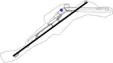
St John's - Antigua - V C Bird Intl
Airport details
| Country | Antigua and Barbuda |
| State | Antigua |
| Region | TA |
| Airspace | Piarco Ctr |
| Municipality | Saint George |
| Elevation | 62ft (19m) |
| Timezone | GMT -4 |
| Coordinates | 17.13671, -61.79268 |
| Magnetic var | |
| Type | land |
| Available since | X-Plane v10.32 |
| ICAO code | TAPA |
| IATA code | ANU |
| FAA code | n/a |
Communication
| Antigua - V C Bird Intl Ground Control | 121.900 |
| Antigua - V C Bird Intl Tower | 118.200 |
| Antigua - V C Bird Intl Approach | 119.100 |
Runway info
| Runway 07 / 25 | ||
| length | 3041m (9977ft) | |
| bearing | 59° / 239° | |
| width | 45m (148ft) | |
| surface | asphalt | |
| displ threshold | 500m (1640ft) / 300m (984ft) | |
| blast zone | 15m (49ft) / 0m (0ft) | |
Nearby beacons
| code | identifier | dist | bearing | frequency |
|---|---|---|---|---|
| ANU | V C BIRD (SAINT JOHNS) VOR/DME | 0.7 | 215° | 114.50 |
| ZDX | V C BIRD (SAINT JOHNS) NDB | 1.2 | 353° | 369 |
| PTP | POINTE A PITRE NDB | 52 | 169° | 385 |
| PPR | POINTE A PITRE VOR/DME | 54.3 | 164° | 112.90 |
| SKB | L BRADSHAW (ST KIT DME | 54.6 | 280° | 112 |
| SKB | ROBERT L BRADSHAW (ST KITTS) NDB | 55.3 | 279° | 325 |
Instrument approach procedures
| runway | airway (heading) | route (dist, bearing) |
|---|---|---|
| RW07 | BEVAN (117°) | BEVAD 2500ft NAKAL (62mi, 250°) 2500ft GABSA (6mi, 239°) 2500ft KEBOR (5mi, 239°) 2500ft EMALI (6mi, 147°) 2500ft |
| RW07 | BEVAS (286°) | BEVAD 2500ft EBLUK (61mi, 239°) 2500ft DUPET (6mi, 239°) 2500ft GADES (5mi, 239°) 2500ft EMALI (6mi, 327°) 2500ft |
| RW07 | BOMET (99°) | BOMET 2500ft EMALI (18mi, 123°) 2500ft |
| RW07 | ELOPO (124°) | ELOPO 2500ft KEBOR (44mi, 135°) 2500ft EMALI (6mi, 147°) 2500ft |
| RW07 | EMALI (59°) | EMALI 2500ft |
| RW07 | KASKI (345°) | KASKI 2500ft GADES (20mi, 316°) 2500ft EMALI (6mi, 327°) 2500ft |
| RW07 | LAMKN (169°) | LAMKN 2500ft KEBOR (53mi, 183°) 2500ft EMALI (6mi, 147°) 2500ft |
| RW07 | MEDUS (331°) | MEDUS 2500ft GADES (23mi, 302°) 2500ft EMALI (6mi, 327°) 2500ft |
| RNAV | EMALI 2500ft BOPAR (5mi, 59°) 2000ft 40THR (2mi, 59°) 900ft TAPA (5mi, 59°) 108ft LIDOK (7mi, 59°) 2500ft IMUSU (5mi, 59°) IMUSU (turn) |
Disclaimer
The information on this website is not for real aviation. Use this data with the X-Plane flight simulator only! Data taken with kind consent from X-Plane 12 source code and data files. Content is subject to change without notice.
