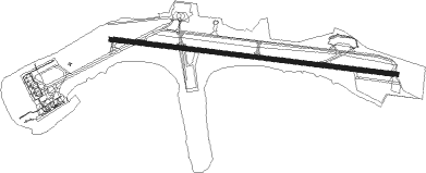
Hamilton - L F Wade Intl
Airport details
| Country | Bermuda |
| State | [Other] |
| Region | TX |
| Airspace | New York Oceanic Ctr |
| Municipality | Saint George's |
| Elevation | 12ft (4m) |
| Timezone | GMT -4 |
| Coordinates | 32.36404, -64.67870 |
| Magnetic var | |
| Type | land |
| Available since | X-Plane v10.40 |
| ICAO code | TXKF |
| IATA code | BDA |
| FAA code | n/a |
Communication
| L F Wade Intl ATIS | 119.600 |
| L F Wade Intl CTAF | 122.800 |
| L F Wade Intl Ground Control | 124.500 |
| L F Wade Intl Tower | 118.100 |
| L F Wade Intl NEW YORK Approach | 119.100 |
| L F Wade Intl NEW YORK Approach | 128.500 |
| L F Wade Intl NEW YORK Departure | 119.100 |
Approach frequencies
| ILS-cat-I | RW30 | 109.9 | 18.00mi |
| 3° GS | RW30 | 109.9 | 18.00mi |
Nearby Points of Interest:
St George and Related Fortifications
Nearby beacons
| code | identifier | dist | bearing | frequency |
|---|---|---|---|---|
| BDA | BERMUDA VOR/DME | 0.5 | 272° | 113.90 |
Departure and arrival routes
| Transition altitude | 18000ft |
| Transition level | 18000ft |
| SID end points | distance | outbound heading | |
|---|---|---|---|
| RW12 | |||
| BORNN1 | 180mi | 284° | |
| RW30 | |||
| SOMRR1 | 180mi | 284° | |
| STAR starting points | distance | inbound heading | |
|---|---|---|---|
| RW12 | |||
| POPOP1 | 50.7 | 76° | |
| MOMOM1 | 50.7 | 141° | |
| RW30 | |||
| POPOP1 | 50.7 | 76° | |
| MOMOM1 | 50.7 | 141° | |
Instrument approach procedures
| runway | airway (heading) | route (dist, bearing) |
|---|---|---|
| RW12 | UTALE (78°) | UTALE 3000ft VITUT (5mi, 13°) 1700ft |
| RW12 | VENZI (123°) | VENZI 3000ft VITUT (5mi, 194°) 1700ft |
| RW12 | WENAN (100°) | WENAN 3000ft VITUT (6mi, 100°) 1700ft |
| RNAV | VITUT 1700ft TOWUN (5mi, 100°) 1700ft TXKF (5mi, 100°) 68ft CURUN (16mi, 100°) 3000ft CURUN (turn) 3000ft | |
| RW30 | BIDVE (256°) | BIDVE 3000ft CABEM (6mi, 194°) 1500ft |
| RW30 | CURUN (280°) | CURUN 3000ft CABEM (5mi, 280°) 1500ft |
| RW30 | TUDIE (305°) | TUDIE 3000ft CABEM (6mi, 13°) 1500ft |
| RNAV | CABEM 1500ft DERME (6mi, 280°) 1500ft TXKF (5mi, 280°) 68ft WENAN (16mi, 280°) 3000ft WENAN (turn) 3000ft |
Holding patterns
| STAR name | hold at | type | turn | heading* | altitude | leg | speed limit |
|---|---|---|---|---|---|---|---|
| MOMOM1 | GBINS | VHF | right | 57 (237)° | 24000ft - 31000ft | DME 10.0mi | ICAO rules |
| MOMOM1 | MOMOM | VHF | left | 356 (176)° | 6000ft - 14000ft | DME 10.0mi | 210 |
| MOMOM1 | TEDIY | VHF | right | 5 (185)° | 24000ft - 31000ft | DME 10.0mi | ICAO rules |
| MOMOM1 | UNYON | VHF | right | 314 (134)° | 24000ft - 31000ft | DME 10.0mi | ICAO rules |
| POPOP1 | DNSTN | VHF | left | 291 (111)° | 24000ft - 31000ft | DME 10.0mi | ICAO rules |
| POPOP1 | KAPPI | VHF | right | 245 (65)° | 24000ft - 31000ft | DME 10.0mi | ICAO rules |
| POPOP1 | POPOP | VHF | right | 292 (112)° | 6000ft - 14000ft | DME 10.0mi | 210 |
| *) magnetic outbound (inbound) holding course | |||||||
Disclaimer
The information on this website is not for real aviation. Use this data with the X-Plane flight simulator only! Data taken with kind consent from X-Plane 12 source code and data files. Content is subject to change without notice.
