Jamnagar
Airport details
| Country | India |
| State | Gujarat |
| Region | VA |
| Airspace | Mumbai Ctr |
| Municipality | Jamnagar City Taluka |
| Elevation | 68ft (21m) |
| Timezone | GMT +5.5 |
| Coordinates | 22.46333, 70.01167 |
| Magnetic var | |
| Type | land |
| Available since | X-Plane v10.40 |
| ICAO code | VAJM |
| IATA code | JGA |
| FAA code | n/a |
Communication
| Jamnagar Tower | 123.500 |
Runway info
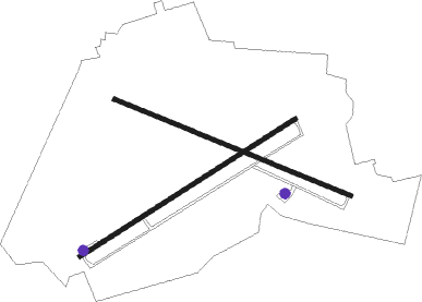
Runway 06 / 24  | ||
| length | 2514m (8248ft) | |
| bearing | 64° / 244° | |
| width | 45m (148ft) | |
| surface | concrete | |
| blast zone | 255m (837ft) / 94m (308ft) | |
| Runway 12 / 30 | ||
| length | 2510m (8235ft) | |
| bearing | 115° / 295° | |
| width | 45m (148ft) | |
| surface | asphalt | |
| blast zone | 255m (837ft) / 255m (837ft) | |
Nearby beacons
| code | identifier | dist | bearing | frequency |
|---|---|---|---|---|
| JNR | JAMNAGAR VOR/DME | 0.3 | 64° | 117.90 |
| JMR | JAMNAGAR NDB | 3.1 | 57° | 257 |
| MND | MUNDRA VOR/DME | 26 | 328° | 113.50 |
| KD | KANDLA NDB | 39.2 | 8° | 335 |
| KND | DME | 39.2 | 8° | 117.70 |
| RKT | RAJKOT VOR/DME | 43.4 | 101° | 115.40 |
| RK | RAJKOT NDB | 43.9 | 101° | 329 |
| BHU | BHUJ VOR/DME | 52.6 | 337° | 112.60 |
| PBN | PORBANDAR VOR/DME | 52.6 | 204° | 112.40 |
| PR | PORBANDAR NDB | 53 | 203° | 344 |
Disclaimer
The information on this website is not for real aviation. Use this data with the X-Plane flight simulator only! Data taken with kind consent from X-Plane 12 source code and data files. Content is subject to change without notice.