Kathmandu - Kathmandu Tribhuvan Intl
Airport details
| Country | Nepal |
| State | Bagmati |
| Region | VN |
| Airspace | Kathmandu Ctr |
| Municipality | Kathmandu |
| Elevation | 4390ft (1338m) |
| Timezone | GMT +5.75 |
| Coordinates | 27.69716, 85.35793 |
| Magnetic var | |
| Type | land |
| Available since | X-Plane v10.40 |
| ICAO code | VNKT |
| IATA code | KTM |
| FAA code | n/a |
Communication
| Kathmandu Tribhuvan Intl KATHMANDU ATIS | 127.000 |
| Kathmandu Tribhuvan Intl KATHMANDU Ground Control | 121.900 |
| Kathmandu Tribhuvan Intl KATHMANDU Tower | 118.100 |
| Kathmandu Tribhuvan Intl KATHMANDU Tower | 118.500 |
| Kathmandu Tribhuvan Intl KATHMANDU Approach | 120.600 |
| Kathmandu Tribhuvan Intl KATHMANDU Approach | 125.100 |
Nearby Points of Interest:
Kathmandu Valley
-Kirtipur
-Bajrayogini Temple
-Panauti
-Khokana
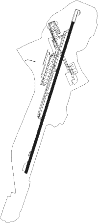
Runway info
| Runway 02 / 20 | ||
| length | 3090m (10138ft) | |
| bearing | 24° / 204° | |
| width | 45m (148ft) | |
| surface | asphalt | |
| displ threshold | 298m (978ft) / 2m (7ft) | |
Nearby beacons
| code | identifier | dist | bearing | frequency |
|---|---|---|---|---|
| KAM | KATHMANDU NDB | 0.3 | 233° | 318 |
| KTM | KATHMANDU VOR/DME | 1.4 | 202° | 113.20 |
| LTH | THECHO (KATHMANDU) NDB | 5.4 | 202° | 230 |
| LNC | NALINCHOWK (KATHMANDU) NDB | 6.3 | 114° | 252 |
| SMR | SIMARA VOR/DME | 37.7 | 215° | 112.90 |
| BHP | BHARATPUR NDB | 49.3 | 269° | 295 |
| JKP | JANAKPUR NDB | 66.3 | 150° | 287 |
Departure and arrival routes
| Transition altitude | 13500ft |
| Transition level | 15000ft |
| SID end points | distance | outbound heading | |
|---|---|---|---|
| RW02 | |||
| IGRI1B | 51mi | 149° | |
| DARK1E, DARK1D, DARK1C | 38mi | 215° | |
| RW20 | |||
| IGRI1A | 51mi | 149° | |
| DARK1A, DARK1B | 38mi | 215° | |
| STAR starting points | distance | inbound heading | |
|---|---|---|---|
| ALL | |||
| ROMEO | 41.6 | 24° | |
| SMR | 37.7 | 35° | |
| NAYAK | 25.5 | 87° | |
| BIDUR | 24.9 | 107° | |
| RW02 | |||
| ROME2R | 41.6 | 24° | |
| SMRA2R | 37.7 | 35° | |
| KMTI1R | 49.9 | 282° | |
| DLAL1R | 30.1 | 283° | |
| IGRS1R | 15.0 | 288° | |
| DARM1R | 24.7 | 305° | |
| MUNA1R | 36.7 | 339° | |
Instrument approach procedures
| runway | airway (heading) | route (dist, bearing) |
|---|---|---|
| RW02 | DANFE (69°) | DANFE 10500ft KT540 (2mi, 137°) KT538 (8mi, 109°) KT536 (7mi, 83°) 10500ft KT534 (9mi, 83°) KT532 (3mi, 55°) KT530 (2mi, 4°) 8700ft |
| RW02 | RATAN (24°) | RATAN 10500ft GURAS (7mi, 24°) KT532 (2mi, 24°) KT530 (2mi, 4°) 8700ft |
| RNAV | KT530 8700ft KT528 (2mi, 343°) 8240ft DOVAN (4mi, 14°) 7100ft KT524 (1mi, 43°) 6740ft KT522 (2mi, 53°) 6260ft KT520 (3mi, 45°) 5280ft VNKT (4mi, 23°) 4370ft KT590 (turn) KT592 (6mi, 119°) KT812 (5mi, 258°) KT814 (2mi, 291°) 7500ft KT914 (7mi, 291°) DARKE (7mi, 291°) KT890 (4mi, 280°) KT892 (8mi, 270°) KT894 (6mi, 251°) KT896 (6mi, 232°) KT898 (11mi, 185°) DANFE (2mi, 137°) 10500ft DANFE (turn) 10500ft |
Holding patterns
| STAR name | hold at | type | turn | heading* | altitude | leg | speed limit |
|---|---|---|---|---|---|---|---|
| DARM1R | RATAN | VHF | left | 202 (22)° | 10500ft - 19000ft | 1.0min timed | 230 |
| DLAL1R | RATAN | VHF | left | 202 (22)° | 10500ft - 19000ft | 1.0min timed | 230 |
| IGRS1R | RATAN | VHF | left | 202 (22)° | 10500ft - 19000ft | 1.0min timed | 230 |
| KMTI1R | MUNAL | VHF | left | 90 (270)° | 10500ft - 19000ft | 1.0min timed | 230 |
| KMTI1R | RATAN | VHF | left | 202 (22)° | 10500ft - 19000ft | 1.0min timed | 230 |
| MUNA1R | MUNAL | VHF | left | 90 (270)° | 10500ft - 19000ft | 1.0min timed | 230 |
| MUNA1R | RATAN | VHF | left | 202 (22)° | 10500ft - 19000ft | 1.0min timed | 230 |
| ROME2R | RATAN | VHF | left | 202 (22)° | 10500ft - 19000ft | 1.0min timed | 230 |
| ROMEO | GURAS | VHF | left | 202 (22)° | 11500ft - 13500ft | 1.0min timed | 230 |
| SMR | GURAS | VHF | left | 202 (22)° | 11500ft - 13500ft | 1.0min timed | 230 |
| SMRA2R | RATAN | VHF | left | 202 (22)° | 10500ft - 19000ft | 1.0min timed | 230 |
| *) magnetic outbound (inbound) holding course | |||||||
Disclaimer
The information on this website is not for real aviation. Use this data with the X-Plane flight simulator only! Data taken with kind consent from X-Plane 12 source code and data files. Content is subject to change without notice.