Bangalore - Kempegowda Intl
Airport details
| Country | India |
| State | Karnataka |
| Region | VO |
| Airspace | Chennai Ctr |
| Municipality | Devanahalli taluk |
| Elevation | 3000ft (914m) |
| Timezone | GMT +5.5 |
| Coordinates | 13.20524, 77.70518 |
| Magnetic var | |
| Type | land |
| Available since | X-Plane v10.40 |
| ICAO code | VOBL |
| IATA code | BLR |
| FAA code | n/a |
Communication
| Kempegowda Intl Bangalore Ground | 121.650 |
| Kempegowda Intl Bangalore Tower | 124.350 |
| Kempegowda Intl Bangalore Approach | 121.250 |
Approach frequencies
| ILS-cat-III | RW09R | 109.9 | 18.00mi |
| ILS-cat-III | RW27L | 111.5 | 18.00mi |
| ILS-cat-I | RW09L | 109.3 | 18.00mi |
| ILS-cat-I | RW27R | 108.3 | 18.00mi |
| 3° GS | RW09L | 109.3 | 18.00mi |
| 3° GS | RW09R | 109.9 | 18.00mi |
| 3° GS | RW27R | 108.3 | 18.00mi |
| 3° GS | RW27L | 111.5 | 18.00mi |
Runway info
Runway 9R / 27L  | ||
| length | 3993m (13100ft) | |
| bearing | 90° / 270° | |
| width | 55m (180ft) | |
| surface | concrete | |
| blast zone | 60m (197ft) / 62m (203ft) | |
| Runway 09L / 27R | ||
| length | 3994m (13104ft) | |
| bearing | 90° / 270° | |
| width | 45m (148ft) | |
| surface | asphalt | |
| blast zone | 63m (207ft) / 59m (194ft) | |
Airport layout
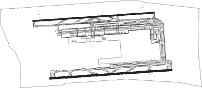
Taxiway locations
Parking locations
|
Nearby beacons
| code | identifier | dist | bearing | frequency |
|---|---|---|---|---|
| BIA | BENGALURU VOR/DME | 1.5 | 87° | 116.80 |
| BBG | BENGALURU VOR/DME | 15.4 | 185° | 115.50 |
| BIB | BENGALURU VOR/DME | 17 | 47° | 114.50 |
| SAI | SRI SATYA SAI NDB | 56.9 | 5° | 241 |
Departure and arrival routes
| Transition altitude | 7000ft |
| SID end points | distance | outbound heading | |
|---|---|---|---|
| RW09L | |||
| SAI7A | 57mi | 5° | |
| LATI7A | 78mi | 11° | |
| ANIR7A | 73mi | 47° | |
| VEMB7A | 70mi | 71° | |
| TULN7A | 83mi | 100° | |
| AKTI7A | 69mi | 186° | |
| PEXE7A | 98mi | 265° | |
| GUNI7A, GUNI7L | 137mi | 292° | |
| OPAM7A | 91mi | 336° | |
| VAGP7A | 161mi | 338° | |
| RW09R | |||
| SAI7C | 57mi | 5° | |
| LATI7C | 78mi | 11° | |
| ANIR7C | 73mi | 47° | |
| VEMB7C | 70mi | 71° | |
| TULN7C | 83mi | 100° | |
| AKTI7C | 69mi | 186° | |
| PEXE7C | 98mi | 265° | |
| GUNI7M, GUNI7C | 137mi | 292° | |
| OPAM7C | 91mi | 336° | |
| VAGP7C | 161mi | 338° | |
| RW27L | |||
| SAI7D | 57mi | 5° | |
| LATI7D | 78mi | 11° | |
| ANIR7D, ANIR7Y | 73mi | 47° | |
| VEMB7Y, VEMB7D | 70mi | 71° | |
| TULN7D | 83mi | 100° | |
| AKTI7D | 69mi | 186° | |
| PEXE7D | 98mi | 265° | |
| GUNI7U, GUNI7D | 137mi | 292° | |
| OPAM7D | 91mi | 336° | |
| VAGP7D | 161mi | 338° | |
| RW27R | |||
| SAI7B | 57mi | 5° | |
| LATI7B | 78mi | 11° | |
| ANIR7S, ANIR7B | 73mi | 47° | |
| VEMB7B, VEMB7S | 70mi | 71° | |
| TULN7B | 83mi | 100° | |
| AKTI7B | 69mi | 186° | |
| PEXE7B | 98mi | 265° | |
| GUNI7B, GUNI7J | 137mi | 292° | |
| OPAM7B | 91mi | 336° | |
| VAGP7B | 161mi | 338° | |
| STAR starting points | distance | inbound heading | |
|---|---|---|---|
| RW09 (ALL) | |||
| UGAB7E | 67.8 | 21° | |
| PEXE7E | 97.6 | 85° | |
| GUNI7E | 137.2 | 112° | |
| SUSI7E, SUSI7J | 114.9 | 128° | |
| RIKB7E | 141.4 | 146° | |
| TELU7E | 63.9 | 207° | |
| XIVI7E | 71.0 | 266° | |
| LEKA7E | 129.7 | 301° | |
| ADKA7E | 88.1 | 337° | |
| RW27 (ALL) | |||
| UGAB7F | 67.8 | 21° | |
| PEXE7F, PEXE7N | 97.6 | 85° | |
| GUNI7F, GUNI7N | 137.2 | 112° | |
| SUSI7L, SUSI7F | 114.9 | 128° | |
| RIKB7F | 141.4 | 146° | |
| TELU7F | 63.9 | 207° | |
| XIVI7F | 71.0 | 266° | |
| LEKA7F | 129.7 | 301° | |
| ADKA7F | 88.1 | 337° | |
Instrument approach procedures
| runway | airway (heading) | route (dist, bearing) |
|---|---|---|
| RW09RY | ATPUK (85°) | ATPUK BL918 (5mi, 76°) 7000ft BL117 (6mi, 90°) 5000ft |
| RW09RY | BL454 (113°) | BL454 7000ft BL117 (7mi, 180°) 5000ft |
| RW09RY | BL458 (74°) | BL458 7000ft BL918 (5mi, 0°) 7000ft BL117 (6mi, 90°) 5000ft |
| RNAV | BL117 5000ft BL116 (7mi, 90°) 5000ft VOBL (7mi, 83°) 3025ft (4687mi, 260°) 3700ft BL912 (4690mi, 80°) BL454 (18mi, 271°) 7000ft BL454 (turn) 7000ft | |
| RW27LY | BL552 (246°) | BL552 BL923 (7mi, 181°) 5000ft |
| RW27LY | BL558 (290°) | BL558 BL920 (5mi, 0°) 7000ft BL923 (3mi, 271°) 5000ft |
| RW27LY | DOXIT (259°) | DOXIT BL920 (14mi, 241°) 7000ft BL923 (3mi, 271°) 5000ft |
| RNAV | BL923 5000ft BL921 (6mi, 271°) 5000ft VOBL (8mi, 277°) 3017ft BL901 (15mi, 267°) BL902 (7mi, 0°) BL552 (29mi, 90°) 6000ft BL552 (turn) 6000ft |
Holding patterns
| STAR name | hold at | type | turn | heading* | altitude | leg | speed limit |
|---|---|---|---|---|---|---|---|
| ADKA7E | GURBI | VHF | right | 160 (340)° | 12000ft - 24000ft | 1.0min timed | 230 |
| ADKA7F | GURBI | VHF | right | 160 (340)° | 12000ft - 24000ft | 1.0min timed | 230 |
| GUNI7F | ATPUK | VHF | left | 267 (87)° | 15000ft - 24000ft | 1.0min timed | 230 |
| GUNI7N | ATPUK | VHF | left | 267 (87)° | 15000ft - 24000ft | 1.0min timed | 230 |
| LEKA7E | GURBI | VHF | right | 160 (340)° | 12000ft - 24000ft | 1.0min timed | 230 |
| LEKA7F | GURBI | VHF | right | 160 (340)° | 12000ft - 24000ft | 1.0min timed | 230 |
| PEXE7E | BL807 | VHF | left | 267 (87)° | 15000ft - 24000ft | 1.0min timed | 230 |
| PEXE7F | ATPUK | VHF | left | 267 (87)° | 15000ft - 24000ft | 1.0min timed | 230 |
| PEXE7F | BL807 | VHF | left | 267 (87)° | 15000ft - 24000ft | 1.0min timed | 230 |
| PEXE7N | ATPUK | VHF | left | 267 (87)° | 15000ft - 24000ft | 1.0min timed | 230 |
| PEXE7N | BL807 | VHF | left | 267 (87)° | 15000ft - 24000ft | 1.0min timed | 230 |
| RIKB7E | BL805 | VHF | right | 329 (149)° | 15000ft - 24000ft | 1.0min timed | 230 |
| RIKB7E | RIGBA | VHF | left | 329 (149)° | 12000ft - 24000ft | 1.0min timed | 230 |
| RIKB7F | BL805 | VHF | right | 329 (149)° | 15000ft - 24000ft | 1.0min timed | 230 |
| RIKB7F | RIGBA | VHF | left | 329 (149)° | 12000ft - 24000ft | 1.0min timed | 230 |
| SUSI7E | BL805 | VHF | right | 329 (149)° | 15000ft - 24000ft | 1.0min timed | 230 |
| SUSI7E | RIGBA | VHF | left | 329 (149)° | 12000ft - 24000ft | 1.0min timed | 230 |
| SUSI7F | BL805 | VHF | right | 329 (149)° | 15000ft - 24000ft | 1.0min timed | 230 |
| SUSI7F | RIGBA | VHF | left | 329 (149)° | 12000ft - 24000ft | 1.0min timed | 230 |
| SUSI7J | RIGBA | VHF | left | 329 (149)° | 12000ft - 24000ft | 1.0min timed | 230 |
| SUSI7L | RIGBA | VHF | left | 329 (149)° | 12000ft - 24000ft | 1.0min timed | 230 |
| TELU7E | RURPA | VHF | left | 4 (184)° | 12000ft - 24000ft | 1.0min timed | 230 |
| TELU7E | TELUV | VHF | left | 27 (207)° | 15000ft - 24000ft | 1.0min timed | 230 |
| TELU7F | RURPA | VHF | left | 4 (184)° | 12000ft - 24000ft | 1.0min timed | 230 |
| TELU7F | TELUV | VHF | left | 27 (207)° | 15000ft - 24000ft | 1.0min timed | 230 |
| UGAB7E | MUGPA | VHF | right | 204 (24)° | 12000ft - 24000ft | 1.0min timed | 230 |
| UGAB7F | MUGPA | VHF | right | 204 (24)° | 12000ft - 24000ft | 1.0min timed | 230 |
| XIVI7E | DOXIT | VHF | right | 101 (281)° | 12000ft - 24000ft | 1.0min timed | 230 |
| XIVI7F | DOXIT | VHF | right | 101 (281)° | 12000ft - 24000ft | 1.0min timed | 230 |
| *) magnetic outbound (inbound) holding course | |||||||
Disclaimer
The information on this website is not for real aviation. Use this data with the X-Plane flight simulator only! Data taken with kind consent from X-Plane 12 source code and data files. Content is subject to change without notice.