Chennai - Chennai Intl
Airport details
| Country | India |
| State | Tamil Nadu |
| Region | VO |
| Airspace | Chennai Ctr |
| Municipality | St. Thomas Mount Cantonment |
| Elevation | 49ft (15m) |
| Timezone | GMT +5.5 |
| Coordinates | 12.99770, 80.17982 |
| Magnetic var | |
| Type | land |
| Available since | X-Plane v10.40 |
| ICAO code | VOMM |
| IATA code | MAA |
| FAA code | n/a |
Communication
| Chennai Intl Chennai Intl ATIS | 127.450 |
| Chennai Intl Chennai Intl Ground Control | 121.900 |
| Chennai Intl Chennai Intl Tower | 118.100 |
| Chennai Intl Chennai Intl Approach | 127.900 |
| Chennai Intl Chennai Intl Approach | 124.450 |
Approach frequencies
| ILS-cat-I | RW25 | 109.7 | 18.00mi |
| ILS-cat-I | RW07 | 110.3 | 18.00mi |
| 3° GS | RW25 | 109.7 | 18.00mi |
| 3° GS | RW07 | 110.3 | 18.00mi |
Nearby Points of Interest:
Dhenupureeswarar Temple (Madambakkam)
-Krishna's Butterball
-Mahabalipuram temples
-Mahishasuramardini Mandapa
-Descent of the Ganges
-Bhima Ratha
-Dharmaraja Ratha
-Matangesvara Temple
-Vaikunda Perumal Temple, Uthiramerur
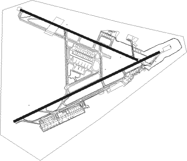
Runway info
Runway 07 / 25  | ||
| length | 3658m (12001ft) | |
| bearing | 69° / 249° | |
| width | 45m (148ft) | |
| surface | asphalt | |
| blast zone | 147m (482ft) / 150m (492ft) | |
| Runway 12 / 30 | ||
| length | 2891m (9485ft) | |
| bearing | 117° / 297° | |
| width | 45m (148ft) | |
| surface | asphalt | |
| displ threshold | 778m (2552ft) / 0m (0ft) | |
Nearby beacons
| code | identifier | dist | bearing | frequency |
|---|---|---|---|---|
| CNI | CHENNAI VOR/DME | 0.8 | 296° | 114.90 |
| MMV | CHENNAI VOR/DME | 1.5 | 248° | 112.50 |
| MA | CHENNAI NDB | 6.6 | 248° | 228 |
| KKP | KANCHEEPURAM VOR/DME | 30.1 | 246° | 115.40 |
| TTP | TIRUPATI VOR/DME | 52.5 | 316° | 115.70 |
Departure and arrival routes
| Transition altitude | 4000ft |
| SID end points | distance | outbound heading | |
|---|---|---|---|
| RW07 | |||
| KOLCA | 85mi | 61° | |
| SIDAT | 199mi | 96° | |
| OXENA | 203mi | 114° | |
| DAMAD | 180mi | 182° | |
| PATTY | 101mi | 213° | |
| HALCO | 76mi | 283° | |
| DOHIA | 127mi | 339° | |
| RW12 | |||
| KOLCA | 85mi | 61° | |
| SIDAT | 199mi | 96° | |
| OXENA | 203mi | 114° | |
| DAMAD | 180mi | 182° | |
| PATTY | 101mi | 213° | |
| HALCO | 76mi | 283° | |
| DOHIA | 127mi | 339° | |
| RW25 | |||
| KOLCA | 85mi | 61° | |
| SIDAT | 199mi | 96° | |
| OXENA | 203mi | 114° | |
| COLTY | 101mi | 213° | |
| HALCO | 76mi | 283° | |
| DOHIA | 127mi | 339° | |
| RW30 | |||
| KOLCA | 85mi | 61° | |
| SIDAT | 199mi | 96° | |
| OXENA | 203mi | 114° | |
| COLTY | 101mi | 213° | |
| HALCO | 76mi | 283° | |
| DOHIA | 127mi | 339° | |
| STAR starting points | distance | inbound heading | |
|---|---|---|---|
| RW07 | |||
| TRYCO | 40.3 | 28° | |
| BUTLA | 40.7 | 78° | |
| GUANI | 40.3 | 129° | |
| RUPKU | 39.8 | 194° | |
| RAAGA, GAVID | 39.5 | 287° | |
| RW12 | |||
| TRYCO | 40.3 | 28° | |
| BUTLA | 40.7 | 78° | |
| GUANI | 40.3 | 129° | |
| RUPKU | 39.8 | 194° | |
| GAVID | 39.5 | 287° | |
| RW25 | |||
| TRYCO | 40.3 | 28° | |
| BUTLA | 40.7 | 78° | |
| GUANI | 40.3 | 129° | |
| RUPKU | 39.8 | 194° | |
| GAVID | 39.5 | 287° | |
| ARDAB | 40.3 | 348° | |
| RW30 | |||
| TRYCO | 40.3 | 28° | |
| ACUBU, BUTLA | 40.7 | 78° | |
| GUANI | 40.3 | 129° | |
| RUPKU | 39.8 | 194° | |
| GAVID | 39.5 | 287° | |
| ARDAB | 40.3 | 348° | |
Instrument approach procedures
| runway | airway (heading) | route (dist, bearing) |
|---|---|---|
| RW07-Y | MM513 (89°) | MM513 2300ft MM915 (6mi, 153°) 2300ft |
| RW07-Y | MM514 (48°) | MM514 2300ft MM915 (6mi, 345°) 2300ft |
| RW07-Y | MM911 (69°) | MM911 2300ft MM915 (7mi, 69°) 2300ft |
| RNAV | MM915 2300ft MM916 (7mi, 69°) 2100ft VOMM (8mi, 68°) 93ft MM917 (5mi, 72°) MM918 (7mi, 339°) MM513 (21mi, 247°) MM915 (6mi, 153°) 2300ft MM915 (turn) 2300ft | |
| RW12-Y | MM515 (135°) | MM515 2300ft MM815 (10mi, 165°) 2100ft |
| RW12-Y | MM516 (99°) | MM516 2300ft MM815 (10mi, 71°) 2100ft |
| RW12-Y | MM811 (117°) | MM811 2300ft MM815 (7mi, 117°) 2100ft |
| RNAV | MM815 2100ft MM816 (7mi, 117°) 2100ft VOMM (8mi, 116°) 94ft MM817 (6mi, 119°) MM818 (7mi, 28°) MM813 (20mi, 297°) MM815 (7mi, 208°) 2100ft MM815 (turn) 2100ft | |
| RW25-Y | MM510 (227°) | MM510 2300ft MM715 (6mi, 162°) 2300ft |
| RW25-Y | MM512 (272°) | MM512 2300ft MM715 (6mi, 334°) 2300ft |
| RW25-Y | MM711 (250°) | MM711 2300ft MM715 (7mi, 249°) 2300ft |
| RNAV | MM715 2300ft MM716 (7mi, 249°) 2100ft VOMM (7mi, 251°) 104ft MM717 (7mi, 248°) MM718 (7mi, 339°) MM510 (21mi, 72°) MM715 (6mi, 162°) 2300ft MM715 (turn) 2300ft | |
| RW30-Y | MM411 (298°) | MM411 2300ft MM415 (7mi, 297°) 2100ft |
| RW30-Y | MM509 (320°) | MM509 2300ft MM415 (6mi, 26°) 2100ft |
| RW30-Y | MM512 (272°) | MM512 2300ft MM415 (7mi, 212°) 2100ft |
| RNAV | MM415 2100ft MM416 (7mi, 297°) 2100ft VOMM (7mi, 299°) 98ft MM417 (7mi, 296°) MM418 (7mi, 28°) MM512 (21mi, 118°) MM415 (7mi, 212°) 2100ft MM415 (turn) 2100ft |
Holding patterns
| STAR name | hold at | type | turn | heading* | altitude | leg | speed limit |
|---|---|---|---|---|---|---|---|
| ACUBU | BUTLA | VHF | left | 251 (71)° | 9000ft - 18000ft | DME 10.0mi | 250 |
| ARDAB | ARDAB | VHF | right | 185 (5)° | 9000ft - 18000ft | DME 10.0mi | 250 |
| BUTLA | BUTLA | VHF | left | 251 (71)° | 9000ft - 18000ft | DME 10.0mi | 250 |
| GAVID | GAVID | VHF | right | 112 (292)° | 9000ft - 18000ft | DME 10.0mi | 250 |
| GUANI | GUANI | VHF | right | 303 (123)° | 9000ft - 18000ft | DME 10.0mi | 250 |
| RAAGA | GAVID | VHF | right | 112 (292)° | 9000ft - 18000ft | DME 10.0mi | 250 |
| RUPKU | RUPKU | VHF | left | 14 (194)° | 9000ft - 18000ft | DME 10.0mi | 250 |
| TRYCO | TRYCO | VHF | right | 195 (15)° | 9000ft - 18000ft | DME 10.0mi | 250 |
| *) magnetic outbound (inbound) holding course | |||||||
Disclaimer
The information on this website is not for real aviation. Use this data with the X-Plane flight simulator only! Data taken with kind consent from X-Plane 12 source code and data files. Content is subject to change without notice.