Chiang Mai - Chiang Mai Intl
Airport details
| Country | Thailand |
| State | Chiang Mai Province |
| Region | VT |
| Airspace | Bangkok Ctr |
| Municipality | Chiang Mai |
| Elevation | 1036ft (316m) |
| Timezone | GMT +7 |
| Coordinates | 18.77956, 98.96609 |
| Magnetic var | |
| Type | land |
| Available since | X-Plane v10.40 |
| ICAO code | VTCC |
| IATA code | CNX |
| FAA code | n/a |
Communication
| Chiang Mai Intl ATIS | 127.200 |
| Chiang Mai Intl Ground Control | 121.900 |
| Chiang Mai Intl Tower | 118.100 |
| Chiang Mai Intl Approach | 129.600 |
Approach frequencies
| ILS-cat-I | RW36 | 109.9 | 18.00mi |
| 3° GS | RW36 | 109.9 | 18.00mi |
Nearby Points of Interest:
Chiang Mai city wall
-Chiang Mai
-Wat Hang Dong
-Wat Khun Khong Luang
-Wat Pa Hiang
-Wat Hua Khua
-Wat Phra Yuen
-Wat Mongkhon
-Wat San Sai
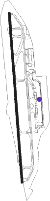
Runway info
| Runway 18 / 36 | ||
| length | 3419m (11217ft) | |
| bearing | 180° / 0° | |
| width | 45m (148ft) | |
| surface | asphalt | |
| displ threshold | 302m (991ft) / 0m (0ft) | |
| blast zone | 0m (0ft) / 104m (341ft) | |
Nearby beacons
| code | identifier | dist | bearing | frequency |
|---|---|---|---|---|
| CHM | CHIANG MAI TACAN | 0.6 | 158° | 116.20 |
| CMA | CHIANG MAI VOR/DME | 0.8 | 200° | 116.90 |
| LPN | LAMPANG VOR/DME | 42.9 | 133° | 114.70 |
| LP | LAMPANG NDB | 43.1 | 133° | 395 |
| MH | MAE HONG SON NDB | 64.3 | 298° | 384 |
Departure and arrival routes
| Transition altitude | 11000ft |
| Transition level | 13000ft |
| SID end points | distance | outbound heading | |
|---|---|---|---|
| RW18 | |||
| PR1A | 78mi | 119° | |
| UTTA1A | 106mi | 126° | |
| PSL1A | 142mi | 147° | |
| KEDO1A | 39mi | 162° | |
| MHS1A | 68mi | 297° | |
| RW36 | |||
| ADLU1N | 24mi | 38° | |
| MONL1N | 38mi | 90° | |
| PR1B | 78mi | 119° | |
| KABM1N | 38mi | 119° | |
| UTTA1B | 106mi | 126° | |
| ASAV1N | 38mi | 126° | |
| PANT1N | 39mi | 147° | |
| PSL1B | 142mi | 147° | |
| ENBA1N, KEDO1B | 39mi | 162° | |
| GOGO1N | 39mi | 189° | |
| PUMA1N | 39mi | 192° | |
| VISE1N, VISE1X | 25mi | 296° | |
| MHS1B | 68mi | 297° | |
| LAMU1X, LAMU1N | 25mi | 317° | |
| STAR starting points | distance | inbound heading | |
|---|---|---|---|
| RW36 | |||
| GOGO1A | 39.0 | 9° | |
| PUMA1A | 39.0 | 12° | |
| VISE1A | 24.8 | 116° | |
| LAMU1A | 24.6 | 137° | |
| ADLU1A | 24.2 | 218° | |
| MONL1A | 37.6 | 270° | |
| KABM1A | 38.1 | 299° | |
| ASAV1A | 38.3 | 306° | |
| PANT1A | 38.6 | 327° | |
| ENBA1A | 38.8 | 342° | |
| MARN1A | 38.9 | 348° | |
Instrument approach procedures
| runway | airway (heading) | route (dist, bearing) |
|---|---|---|
| RW18 | ADLUS (218°) | ADLUS 8000ft PAPAI (10mi, 218°) 8000ft LAMMY (7mi, 281°) 5200ft MALIM (4mi, 211°) 3700ft |
| RW18 | ANGET (138°) | ANGET 9000ft WANCA (6mi, 114°) 8000ft ZUTEP (5mi, 114°) 5600ft MALIM (5mi, 114°) 3700ft |
| RW18 | NIWAT (308°) | NIWAT 8000ft WISTA (8mi, 356°) 8000ft PAPAI (12mi, 356°) 8000ft LAMMY (7mi, 281°) 5200ft MALIM (4mi, 211°) 3700ft |
| RW18 | YAMUN (116°) | YAMUN 9000ft WANCA (12mi, 72°) 8000ft ZUTEP (5mi, 114°) 5600ft MALIM (5mi, 114°) 3700ft |
| RNAV | MALIM 3700ft CNXNF (6mi, 180°) 2500ft SAPUT (turn) 2200ft VTCC (4mi, 177°) 1086ft NEWLY (21mi, 181°) NIWAT (16mi, 42°) 8000ft NIWAT (turn) 8000ft | |
| RW36 | BAIPU (1°) | BAIPU 7000ft MAKOK (7mi, 0°) 5600ft |
| RW36 | EASTA (344°) | EASTA 7000ft MAKOK (10mi, 314°) 5600ft |
| RW36 | NAZAI (338°) | NAZAI 7000ft MAKOK (7mi, 270°) 5600ft |
| RW36 | PINNY (23°) | PINNY 6000ft MAKOK (7mi, 90°) 5600ft |
| RNAV | MAKOK 5600ft CNXSF (9mi, 0°) 3500ft MA36 (6mi, 0°) 1671ft SAIYA (7mi, 11°) DANAI (5mi, 90°) EASTA (28mi, 179°) 7000ft EASTA (turn) 7000ft |
Holding patterns
| STAR name | hold at | type | turn | heading* | altitude | leg | speed limit |
|---|---|---|---|---|---|---|---|
| ADLU1A | MAKOK | VHF | right | 181 (1)° | > 5600ft | DME 3.8mi | 210 |
| ASAV1A | MAKOK | VHF | right | 181 (1)° | > 5600ft | DME 3.8mi | 210 |
| ENBA1A | MAKOK | VHF | right | 181 (1)° | > 5600ft | DME 3.8mi | 210 |
| GOGO1A | MAKOK | VHF | right | 181 (1)° | > 5600ft | DME 3.8mi | 210 |
| KABM1A | MAKOK | VHF | right | 181 (1)° | > 5600ft | DME 3.8mi | 210 |
| LAMU1A | MAKOK | VHF | right | 181 (1)° | > 5600ft | DME 3.8mi | 210 |
| MARN1A | MAKOK | VHF | right | 181 (1)° | > 5600ft | DME 3.8mi | 210 |
| MONL1A | MAKOK | VHF | right | 181 (1)° | > 5600ft | DME 3.8mi | 210 |
| PANT1A | MAKOK | VHF | right | 181 (1)° | > 5600ft | DME 3.8mi | 210 |
| PUMA1A | MAKOK | VHF | right | 181 (1)° | > 5600ft | DME 3.8mi | 210 |
| VISE1A | MAKOK | VHF | right | 181 (1)° | > 5600ft | DME 3.8mi | 210 |
| *) magnetic outbound (inbound) holding course | |||||||
Disclaimer
The information on this website is not for real aviation. Use this data with the X-Plane flight simulator only! Data taken with kind consent from X-Plane 12 source code and data files. Content is subject to change without notice.