Kuala Lumpur - Kuala Lumpur Simpang
Airport details
| Country | Malaysia |
| State | Wilayah Persekutuan Kuala Lumpur |
| Region | WM |
| Airspace | Kuala Lumpur Ctr |
| Municipality | Kuala Lumpur |
| Elevation | 109ft (33m) |
| Timezone | GMT +8 |
| Coordinates | 3.11139, 101.70277 |
| Magnetic var | |
| Type | land |
| Available since | X-Plane v10.40 |
| ICAO code | WMKF |
| IATA code | n/a |
| FAA code | n/a |
Communication
| Kuala Lumpur Simpang Tower | 127.800 |
| Kuala Lumpur Simpang Tower | 126.500 |
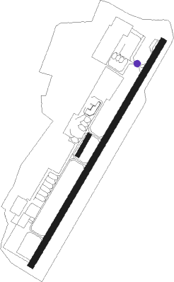
Runway info
Runway 04 / 22  | ||
| length | 1841m (6040ft) | |
| bearing | 35° / 215° | |
| width | 45m (148ft) | |
| surface | asphalt | |
| displ threshold | 331m (1086ft) / 345m (1132ft) | |
| blast zone | 0m (0ft) / 55m (180ft) | |
| Runway 03 / 21 | ||
| length | 158m (518ft) | |
| bearing | 35° / 215° | |
| width | 30m (97ft) | |
| surface | dirt | |
Nearby beacons
| code | identifier | dist | bearing | frequency |
|---|---|---|---|---|
| CE | CALEDONIAN (KUALA LUMPUR) NDB | 18.6 | 306° | 205 |
| VBA | BATU ARANG VOR/DME | 19.5 | 311° | 114.70 |
| VSP | SEPANG VOR/DME | 21.6 | 185° | 114.40 |
| VKL | KUALA LUMPUR VOR/DME | 23.3 | 175° | 116.10 |
| VMK | MALACCA VOR/DME | 60.7 | 148° | 117.40 |
Disclaimer
The information on this website is not for real aviation. Use this data with the X-Plane flight simulator only! Data taken with kind consent from X-Plane 12 source code and data files. Content is subject to change without notice.