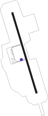
Suai - Xanana Gusmao Intl
Airport details
| Country | Timor-Leste |
| State | Cova Lima |
| Region | WP |
| Airspace | Ujung Pandang Ctr |
| Municipality | Maucatar |
| Elevation | 120ft (37m) |
| Timezone | GMT +9 |
| Coordinates | -9.30002, 125.28362 |
| Magnetic var | |
| Type | land |
| Available since | X-Plane v10.40 |
| ICAO code | WPDB |
| IATA code | UAI |
| FAA code | n/a |
Communication
| Xanana Gusmao Intl TIMOR COMMON LOW | 127.100 |
Nearby Points of Interest:
Marobo hot springs
-Memorial do Dom Aleixo
-Fort Balibo
-Reduto do Conselheiro Jacinto Cândido
Nearby beacons
| code | identifier | dist | bearing | frequency |
|---|---|---|---|---|
| SUI | SUAI VOR/DME | 0.3 | 43° | 114.10 |
| HLW | ATAMBUA VOR/DME | 25.9 | 301° | 112.50 |
| DIL | DILI VOR/DME | 47.6 | 18° | 113.40 |
| OEC | OECUSSI VOR/DME | 56.8 | 276° | 113.60 |
Departure and arrival routes
| Transition altitude | 12000ft |
| Transition level | 14000ft |
| SID end points | distance | outbound heading | |
|---|---|---|---|
| RW17 | |||
| ISMU1A | 72mi | 106° | |
| KIKE1A | 61mi | 125° | |
Instrument approach procedures
| runway | airway (heading) | route (dist, bearing) |
|---|---|---|
| RW35 | IGESA (198°) | IGESA 11000ft EKOBA (8mi, 161°) 7500ft UGRID (11mi, 161°) 3900ft BITUG (4mi, 230°) 3000ft ISLOT (5mi, 277°) 1700ft |
| RW35 | KIGEK (347°) | KIGEK 3000ft ISLOT (5mi, 347°) 1700ft |
| RW35 | KIKEM (305°) | KIKEM UGRID (49mi, 305°) 3900ft BITUG (4mi, 230°) 3000ft ISLOT (5mi, 277°) 1700ft |
| RW35 | NUGDO (11°) | NUGDO 3000ft ISLOT (5mi, 58°) 1700ft |
| RNAV | ISLOT 1700ft DB419 (3mi, 347°) 1700ft DB418 (4mi, 347°) 601ft UGRID (10mi, 116°) BITUG (4mi, 230°) 3000ft |
Disclaimer
The information on this website is not for real aviation. Use this data with the X-Plane flight simulator only! Data taken with kind consent from X-Plane 12 source code and data files. Content is subject to change without notice.
