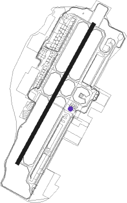
Seletar
Airport details
| Country | Singapore |
| State | North East |
| Region | WS |
| Airspace | Singapore Ctr |
| Municipality | Singapore |
| Elevation | 43ft (13m) |
| Timezone | GMT +8 |
| Coordinates | 1.41121, 103.86765 |
| Magnetic var | |
| Type | land |
| Available since | X-Plane v10.40 |
| ICAO code | WSSL |
| IATA code | XSP |
| FAA code | n/a |
Communication
| Seletar Ground Control | 121.600 |
| Seletar Tower | 130.200 |
| Seletar Tower | 118.450 |
| Seletar SINGAPORE Approach/Departure | 120.300 |
| Seletar SINGAPORE Approach/Departure | 124.600 |
Nearby Points of Interest:
The Chinese High School Clock Tower Building
-Saint Joseph's Church
-MacDonald House
-Maghain Aboth Synagogue
-Church of Saints Peter and Paul
-House of Tan Yeok Nee
-Cathedral of the Good Shepherd
-Chesed-El Synagogue
-Old Tao Nan School
-Central Fire Station, Singapore
-City Hall, Singapore
-Old Hill Street Police Station
-Old Supreme Court Building, Singapore
-Old Ministry of Labour Building
-Yueh Hai Ching Temple
-Sri Mariamman Temple, Singapore
-Tan Teck Guan Building
-College of Medicine Building, Singapore
-Singapore Conference Hall
Nearby beacons
| code | identifier | dist | bearing | frequency |
|---|---|---|---|---|
| SEL | SELETAR (SINGAPORE) NDB | 0.1 | 39° | 220 |
| AG | SEMBAWANG (SINGAPORE) NDB | 2.7 | 285° | 325 |
| PLA | PAYA LEBAR (SINGAPORE) TACAN | 3.6 | 129° | 116.30 |
| PU | PAPA UNIFORM (SINGAPORE) VOR/DME | 4 | 80° | 115.10 |
| VTK | TEKONG (SINGAPORE) VOR/DME | 9.2 | 88° | 116.50 |
| TNG | TENGAH (SINGAPORE) TACAN | 9.4 | 263° | 113.90 |
| KK | KONG KONG (JOHOR BAHRU) NDB | 9.8 | 48° | 286 |
| JB | JAYBEE (JOHOR BAHRU) NDB | 10.7 | 300° | 400 |
| SJ | SINJON (SINGAPORE) VOR/DME | 11.3 | 184° | 113.50 |
| VJB | JOHOR BAHRU VOR/DME | 19.6 | 321° | 112.50 |
| JR | JOHOR BAHRU NDB | 20.1 | 321° | 245 |
| BM | BATAM NDB | 22.7 | 140° | 370 |
| BTM | BATAM VOR/DME | 22.8 | 135° | 116 |
| TG | TANJUNG BALAI KARIMUN NDB | 35.8 | 233° | 410 |
| TI | TANJUNG PINANG NDB | 49.3 | 127° | 385 |
| TPG | TANJUNG PINANG VOR/DME | 49.3 | 128° | 114.80 |
| AP | KLUANG NDB | 50.7 | 318° | 331 |
| VMR | MERSING (JOHOR BAHRU) VOR/DME | 58.6 | 0° | 116.80 |
Disclaimer
The information on this website is not for real aviation. Use this data with the X-Plane flight simulator only! Data taken with kind consent from X-Plane 12 source code and data files. Content is subject to change without notice.