Niagara Falls
Airport details
| Country | Canada |
| State | Ontario |
| Region | CY |
| Airspace | Toronto Ctr |
| Municipality | Niagara Falls |
| Elevation | 576ft (176m) |
| Timezone | GMT -5 |
| Coordinates | 42.99944, -79.06333 |
| Magnetic var | |
| Type | land |
| Available since | X-Plane v10.40 |
| ICAO code | XC004T |
| IATA code | n/a |
| FAA code | n/a |
Communication
Nearby Points of Interest:
Spaulding-Sidway Boathouse
-Holley-Rankine House
-Whitney Mansion (Niagara Falls, New York)
-First Presbyterian Manse
-Jefferson Apartment Building
-Holy Trinity Roman Catholic Church Complex (Niagara Falls, New York)
-Hazard H. Sheldon House
-United States Post Office
-Former Niagara Falls High School
-Park Place Historic District
-Niagara Falls City Hall
-Niagara Falls Armory
-James G. Marshall House
-Chilton Avenue-Orchard Parkway Historic District
-Niagara Falls Public Library
-Niagara Falls Station and Customhouse Interpretive Center
-Johann Williams Farm
-Eberz House
-Kibler High School
-House at 218 Dearborn Street
-Dayton House
-St. Francis Xavier Roman Catholic Parish Complex
-Market Square Historic District
-Dick Block
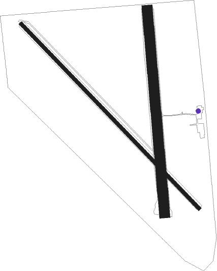
Runway info
Runway 17 / 35  | ||
| length | 1073m (3520ft) | |
| bearing | 180° / 360° | |
| width | 55m (180ft) | |
| surface | grass | |
| Runway 14 / 32 | ||
| length | 1352m (4436ft) | |
| bearing | 132° / 312° | |
| width | 18m (60ft) | |
| surface | gravel | |
Nearby beacons
| code | identifier | dist | bearing | frequency |
|---|---|---|---|---|
| IAG | NIAGARA FALLS TACAN | 8.1 | 42° | 111 |
| IA | KATHI (NIAGRA FALLS) NDB | 11.8 | 64° | 329 |
| SN | ST CATHARINES NDB | 12.2 | 308° | 408 |
| GB | PLAZZ (BUFFALO) NDB | 13.2 | 117° | 204 |
| BU | KLUMP (BUFFALO) NDB | 18.1 | 90° | 231 |
| BUF | BUFFALO VOR/DME | 18.8 | 100° | 116.40 |
| DKK | DME | 31.9 | 202° | 116.20 |
| ZHM | BINBROOK (HAMILTON) NDB | 33.1 | 281° | 266 |
| TZ | GIBRALTAR POINT NDB | 39.4 | 332° | 257 |
| HM | HAMILTON NDB | 42 | 277° | 221 |
| ZYZ | QUEENSWAY (TORONTO) NDB | 42.8 | 322° | 368 |
| ZHA | ANCASTER (HAMILTON) NDB | 43.9 | 282° | 397 |
| YYZ | TORONTO VOR/DME | 46.6 | 319° | 112.15 |
| YTP | PEARSON (TORONTO) VOR/DME | 48.1 | 318° | 116.55 |
| JHW | JAMESTOWN VOR/DME | 48.7 | 184° | 114.70 |
| ZTO | WOODHILL (TORONTO) NDB | 52.4 | 319° | 403 |
| OO | OSHAWA NDB | 55.7 | 10° | 391 |
| YO | DME-ILS | 55.7 | 11° | 111.35 |
| KZ | BUTTONVILLE NDB | 57.2 | 344° | 248 |
Disclaimer
The information on this website is not for real aviation. Use this data with the X-Plane flight simulator only! Data taken with kind consent from X-Plane 12 source code and data files. Content is subject to change without notice.