Westheim - Geilsheim
Airport details
| Country | Germany |
| State | Bavaria |
| Region | |
| Airspace | Munich Ctr |
| Municipality | Wassertrüdingen |
| Elevation | 1563ft (476m) |
| Timezone | GMT +1 |
| Coordinates | 49.02428, 10.65750 |
| Magnetic var | |
| Type | land |
| Available since | X-Plane v10.40 |
| ICAO code | XED7G |
| IATA code | n/a |
| FAA code | n/a |
Communication
| Geilsheim Geilsheim Info | 123.425 |
Nearby Points of Interest:
Pfarrhaus Geilsheim
-Burg Rechenberg
-Burg Hohentrüdingen
-Town hall in Wassertrüdingen
-Brauereigasthof Gnotzheim
-Pfarrhaus
-Gemeindeturm Nordstetten
-Synagogue in Hainsfarth
-Schloss Dennenlohe
-Burg Stahelsberg
-Lunkenburg
-Church in Großlellenfeld
-Weebers Eck
-Kirchenplatz 1
-Haus des Stadtvogts J. L. Beeg
-Storchenturm
-Haus Marktplatz 28
-Amtshaus (Gunzenhausen)
-Rathaus
-Altmühlkreuz
-Hafnermarkt 13
-Brunnenstraße 8
-Palais Zocha
-Fachwerkhaus Hospet
-Dr.-Martin-Luther-Platz 4
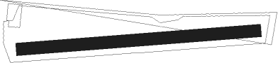
Runway info
| Runway 08 / 26 | ||
| length | 376m (1234ft) | |
| bearing | 90° / 270° | |
| width | 20m (66ft) | |
| surface | grass | |
Nearby beacons
| code | identifier | dist | bearing | frequency |
|---|---|---|---|---|
| ANS | ANSBACH NDB | 17.1 | 355° | 452 |
| DKB | DINKELSBUEHL VORTAC | 17.9 | 286° | 117.80 |
| NEU | NEUBURG TACAN | 28.7 | 119° | 108.90 |
| ILM | ILLESHEIM NDB | 28.8 | 329° | 488 |
| NUB | NUERNBERG VOR/DME | 32.3 | 38° | 115.75 |
| WLD | WALDA VOR/DME | 32.5 | 133° | 112.80 |
| NGD | DME | 33 | 42° | 113.10 |
| SHD | HALL DME | 35 | 276° | 108.05 |
| NDD | DME-ILS | 35.1 | 298° | 108.70 |
| NSN | NIEDERSTETTEN NDB | 35.1 | 298° | 311 |
| RTB | ROETHENBACH NDB | 36 | 52° | 415 |
| AGB | AUGSBURG NDB | 37.6 | 155° | 318 |
| AUG | DME | 37.6 | 155° | 115.90 |
| IGL | INGOLSTADT TACAN | 40.4 | 109° | 111.40 |
| ERL | ERLANGEN VOR/DME | 42.5 | 38° | 114.90 |
| IGL | INGOLSTADT NDB | 42.6 | 106° | 345 |
| MIQ | MIKE NDB | 46.1 | 116° | 426 |
| LCH | LECHFELD TACAN | 50.7 | 166° | 108.80 |
| MAH | MAISACH VOR/DME | 52.5 | 139° | 115.20 |
| LUP | LAUPHEIM NDB | 56.7 | 223° | 407 |
| MSE | MUNICH NDB | 57.2 | 125° | 358 |
| OBI | OBERPFAFFENHOFEN NDB | 61.9 | 146° | 429 |
| BAY | BAYREUTH VOR | 69.1 | 46° | 110.60 |
Disclaimer
The information on this website is not for real aviation. Use this data with the X-Plane flight simulator only! Data taken with kind consent from X-Plane 12 source code and data files. Content is subject to change without notice.