Airports for X-Plane offers a convenient way to explore airports and their related communication information for the X-Plane flight simulator. It only uses data from the X-Plane flight simulator itself, and is therefore more reliable than the data that comes from real aviation websites. You can search for airports by using the ICAO code, or browse for airports per country and state. The information displayed is categorized by airport details, runway information, airport communication, approach frequencies (ILS and Glidepath details), details of nearby beacons, SIDs, STARs and approach procedures.

stopover stolport flight runway lighting seaplane aircraft carrier seaplanes propeller plane corporation newark air safety flown public transport frankfurt airport airfield traffic pattern rail airport airports takeoff taxi

Boerger - Flugplatz Steinberg Surwold

Airport details

CountryGermany
StateLower Saxony
Region
AirspaceBremen Ctr
MunicipalitySurwold
Elevation0ft (0m)
TimezoneGMT +1
Coordinates52.95820, 7.55563
Magnetic var
Typeland
Available sinceX-Plane v10.40
ICAO codeXEDFN
IATA coden/a
FAA coden/a

Communication

Flugplatz Steinberg Surwold ATC127.540
Nearby Points of Interest:
Ludmillenhof
-
St. Petrus in Ketten
-
St. Nikolaus
-
Dreifaltigkeitskirche (Collinghorst)
-
Vellager Kirche
-
Mitling-Marker Kirche
-
Reformierte Kirche
-
Stapelmoorer Kirche
-
St. Laurentius und St.Vincentius (Backemoor)
-
St. Johannes Baptist (Grotegaste)
-
St. Cosmas und Damian (Barßel)
-
Holthuser Kirche
-
Organeum
-
St. Joseph
-
Kerk van Sellingen
-
Village church Kirchborgum
-
Esklumer Kirche
-
Leerort
-
Rathaus Leer
-
Amtsgericht Leer
-
Harderwykenburg
-
Rechthuis
-
Church of Vriescheloo
-
Logabirumer Kirche
-
Historischer Garten Tammen in Bunderhee

Runway info

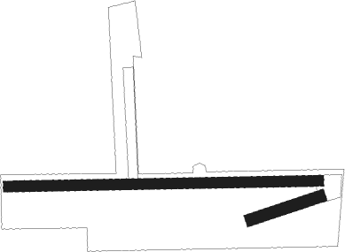
Runway 07 / 25  
 length232m (761ft)
 bearing81° / 261°
 width39m (127ft)
 surfacegrass
Runway 09 / 27  
 length1001m (3284ft)
 bearing92° / 272°
 width34m (112ft)
 surfacegrass
 displ threshold100m (328ft) / 0m (0ft)

Airport layout


Parking locations

Nearby beacons

codeidentifierdistbearingfrequency
EELEELDE (GRONINGEN) VOR/DME34.3283°112.40
WTMWITTMUNDHAFEN TACAN36.316°113.50
DPDIEPHOLZ NDB39.3112°325
MYNMUENSTER/OSNABRUECK NDB48.8163°371
MODDME49.4171°114.05
OSBOSNABRUCK TACAN52.7136°108.35
OSNOSNABRUECK VOR52.7136°114.30
RKNDME57.3224°116.80

Disclaimer

The information on this website is not for real aviation. Use this data with the X-Plane flight simulator only! Data taken with kind consent from X-Plane 12 source code and data files. Content is subject to change without notice.