Mawbeg West - Enniskeane
Airport details
| Country | Ireland |
| State | Cork County |
| Region | |
| Airspace | Shannon Ctr |
| Municipality | The Municipal District of Bandon – Kinsa |
| Elevation | 48ft (15m) |
| Timezone | GMT +0 |
| Coordinates | 51.73717, -8.86188 |
| Magnetic var | |
| Type | land |
| Available since | X-Plane v10.40 |
| ICAO code | XEI001R |
| IATA code | n/a |
| FAA code | n/a |
Communication
Nearby Points of Interest:
Kilnaruane Pillar Stone
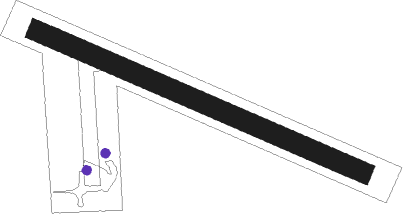
Runway info
| Runway 12 / 30 | ||
| length | 392m (1286ft) | |
| bearing | 108° / 288° | |
| width | 23m (75ft) | |
| surface | grass | |
| displ threshold | 13m (43ft) / 12m (39ft) | |
Nearby beacons
| code | identifier | dist | bearing | frequency |
|---|---|---|---|---|
| CRK | CORK VOR/DME | 15 | 74° | 114.60 |
| KER | KERRY NDB | 36.2 | 304° | 334 |
| FOY | FOYNES NDB | 51.2 | 338° | 395 |
| SHA | SHANNON VOR/DME | 59 | 359° | 113.30 |
Disclaimer
The information on this website is not for real aviation. Use this data with the X-Plane flight simulator only! Data taken with kind consent from X-Plane 12 source code and data files. Content is subject to change without notice.