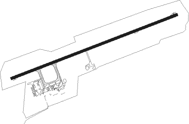
Ballina - Ballina/byron Gateway
Airport details
| Country | Australia |
| State | New South Wales |
| Region | YB |
| Airspace | Brisbane Ctr |
| Municipality | Ballina |
| Elevation | 2ft (1m) |
| Timezone | GMT +10 |
| Coordinates | -28.83389, 153.56250 |
| Magnetic var | |
| Type | land |
| Available since | X-Plane v10.32 |
| ICAO code | YBNA |
| IATA code | BNK |
| FAA code | n/a |
Communication
| Ballina/Byron Gateway Ballina AWIS | 134.800 |
| Ballina/Byron Gateway Ballina CTAF | 124.200 |
Nearby Points of Interest:
Brundah
-Byron Bay railway station
-Colemans Bridge
-Leycester Creek railway bridge
-Lismore railway station
-Mullumbimby Hydro-electric Power Station Complex
-Evans Head Memorial Aerodrome
-Nightcap National Park
-Casino railway station
-Wollumbin National Park
-Murwillumbah railway station
Nearby beacons
| code | identifier | dist | bearing | frequency |
|---|---|---|---|---|
| BNA | BALLINA NDB | 0 | 190° | 206 |
| CG | GOLD COAST VOR/DME | 40 | 355° | 112.30 |
| CG | GOLD COAST NDB | 40.3 | 355° | 278 |
| GFN | GRAFTON NDB | 62.2 | 210° | 389 |
| BML | BROMELTON NDB | 62.7 | 323° | 374 |
Instrument approach procedures
| runway | airway (heading) | route (dist, bearing) |
|---|---|---|
| RW06-X | OPAMI (26°) | OPAMI 3200ft NA410 (6mi, 327°) 3200ft NA420 (3mi, 7°) 2500ft |
| RW06-X | OPESO (63°) | OPESO 3200ft NA420 (5mi, 46°) 2500ft |
| RNAV | NA420 2500ft NA430 (2mi, 61°) 2030ft PUMIP (2mi, 75°) 1400ft YBNA (5mi, 76°) 56ft NA450 (3mi, 75°) (8511mi, 281°) 2000ft | |
| RW06-Z | BNKWE (76°) | BNKWE 3200ft BNKWI (3mi, 75°) 3200ft |
| RW06-Z | BNKWG (100°) | BNKWG 5000ft BNKWI (7mi, 151°) 3200ft |
| RNAV | BNKWI 3200ft BNKWF (4mi, 75°) 1970ft YBNA (7mi, 76°) 56ft BNKWH (2mi, 74°) (8510mi, 281°) 2000ft | |
| RW24-X | AVGUS (26°) | AVGUS 3200ft BERNI (9mi, 351°) 3200ft NA460 (8mi, 53°) 3200ft |
| RW24-X | BERNI (87°) | BERNI 3200ft NA460 (8mi, 53°) 3200ft |
| RNAV | NA460 3200ft LOVRI (4mi, 105°) 1970ft NA470 (3mi, 212°) 850ft YBNA (3mi, 254°) 56ft NA490 (4mi, 256°) (8505mi, 281°) 3200ft | |
| RW24-Z | BNKEA (232°) | BNKEA 2000ft BNKEI (5mi, 161°) 2000ft |
| RW24-Z | BNKEB (255°) | BNKEB 2000ft BNKEI (2mi, 255°) 2000ft |
| RW24-Z | BNKEC (277°) | BNKEC 2000ft BNKEI (5mi, 341°) 2000ft |
| RNAV | BNKEI 2000ft BNKEF (5mi, 255°) 1730ft YBNA (6mi, 255°) 56ft BNKEH (2mi, 257°) BNKEH (turn) 2000ft |
Disclaimer
The information on this website is not for real aviation. Use this data with the X-Plane flight simulator only! Data taken with kind consent from X-Plane 12 source code and data files. Content is subject to change without notice.
