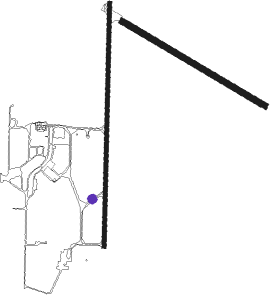
Woomera
Airport details
| Country | Australia |
| State | South Australia |
| Region | YM |
| Airspace | Melbourne Ctr |
| Municipality | Woomera |
| Elevation | 545ft (166m) |
| Timezone | GMT +9.5 |
| Coordinates | -31.15025, 136.80675 |
| Magnetic var | |
| Type | land |
| Available since | X-Plane v10.40 |
| ICAO code | YPWR |
| IATA code | UMR |
| FAA code | n/a |
Communication
| Woomera CTAF | 118.300 |
| Woomera Tower | 118.300 |
Nearby beacons
| code | identifier | dist | bearing | frequency |
|---|---|---|---|---|
| WR | WOOMERA NDB | 0.4 | 12° | 248 |
Instrument approach procedures
| runway | airway (heading) | route (dist, bearing) |
|---|---|---|
| RW18-Z | PWRNA (165°) | PWRNA 2300ft PWRNI (5mi, 113°) 2300ft |
| RW18-Z | PWRNC (188°) | PWRNC 2300ft PWRNI (5mi, 187°) 2300ft |
| RW18-Z | PWRND (210°) | PWRND 2300ft PWRNI (5mi, 258°) 2300ft |
| RNAV | PWRNI 2300ft PWRNF (5mi, 187°) 2260ft PWRNM (5mi, 187°) 677ft PWRNH (3mi, 193°) (7723mi, 283°) 2000ft | |
| RW36 | PWRSB (6°) | PWRSB 2200ft PWRSI (5mi, 7°) 2200ft |
| RW36 | PWRSE (30°) | PWRSE 2200ft PWRSI (5mi, 78°) 2200ft |
| RW36 | PWRSJ (341°) | PWRSJ 2200ft PWRSI (5mi, 293°) 2200ft |
| RNAV | PWRSI 2200ft PWRSF (5mi, 7°) 2190ft PWRSM (5mi, 7°) 599ft PWRSH (3mi, 7°) (7725mi, 283°) 2200ft |
Disclaimer
The information on this website is not for real aviation. Use this data with the X-Plane flight simulator only! Data taken with kind consent from X-Plane 12 source code and data files. Content is subject to change without notice.

