Tamworth
Airport details
| Country | Australia |
| State | New South Wales |
| Region | YB |
| Airspace | Brisbane Ctr |
| Municipality | Tamworth |
| Elevation | 1333ft (406m) |
| Timezone | GMT +10 |
| Coordinates | -31.08389, 150.84666 |
| Magnetic var | |
| Type | land |
| Available since | X-Plane v10.40 |
| ICAO code | YSTW |
| IATA code | TMW |
| FAA code | n/a |
Communication
| Tamworth ATIS | 123.800 |
| Tamworth Ground Control | 121.900 |
| Tamworth Tower | 118.250 |
| Tamworth Departure | 118.250 |
Approach frequencies
| ILS-cat-I | RW30R | 109.9 | 18.00mi |
| 3° GS | RW30R | 109.9 | 18.00mi |
Nearby Points of Interest:
Werris Creek railway station
-Quirindi railway station
-Macdonald River railway bridge, Woolbrook
-Walcha Road railway station
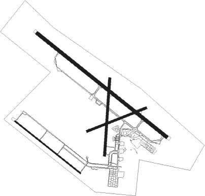
Runway info
Runway 12L / 30R  | ||
| length | 2202m (7224ft) | |
| bearing | 129° / 309° | |
| width | 45m (148ft) | |
| surface | asphalt | |
| Runway 06 / 24 | ||
| length | 839m (2753ft) | |
| bearing | 75° / 255° | |
| width | 30m (98ft) | |
| surface | dirt | |
| Runway 18 / 36 | ||
| length | 1023m (3356ft) | |
| bearing | 190° / 10° | |
| width | 30m (98ft) | |
| surface | dirt | |
| displ threshold | 36m (118ft) / 0m (0ft) | |
| Runway 12R / 30L | ||
| length | 1112m (3648ft) | |
| bearing | 129° / 309° | |
| width | 18m (59ft) | |
| surface | asphalt | |
Nearby beacons
| code | identifier | dist | bearing | frequency |
|---|---|---|---|---|
| TW | TAMWORTH NDB | 1.1 | 309° | 341 |
| TW | TAMWORTH VOR/DME | 1.3 | 317° | 116 |
| QDI | QUIRINDI NDB | 29.6 | 218° | 386 |
| GDH | GUNNEDAH NDB | 31.7 | 282° | 407 |
| ARM | ARMIDALE NDB | 51.8 | 54° | 401 |
| SCO | SCONE NDB | 57.1 | 181° | 209 |
Instrument approach procedures
| runway | airway (heading) | route (dist, bearing) |
|---|---|---|
| RW12L | STWWD (111°) | STWWD 5600ft STWWI (5mi, 66°) 4600ft |
| RW12L | STWWE (129°) | STWWE 5600ft STWWI (5mi, 129°) 4600ft |
| RW12L | STWWG (150°) | STWWG 5600ft STWWI (5mi, 206°) 4600ft |
| RNAV | STWWI 4600ft STWWF (5mi, 129°) 3010ft STWWM (5mi, 129°) 1419ft STWWH (3mi, 129°) (8313mi, 282°) 3500ft (turn) 5600ft | |
| RW30R | STWEA (288°) | STWEA 5600ft STWEI (5mi, 246°) 4650ft |
| RW30R | STWEB (308°) | STWEB 5600ft STWEI (5mi, 308°) 4650ft |
| RW30R | STWEC (329°) | STWEC 5600ft STWEI (5mi, 26°) 4650ft |
| RNAV | STWEI 4650ft STWEF (5mi, 309°) 3050ft STWEM (5mi, 309°) 1463ft STWEH (3mi, 309°) (8313mi, 282°) 3500ft (turn) 5600ft |
Disclaimer
The information on this website is not for real aviation. Use this data with the X-Plane flight simulator only! Data taken with kind consent from X-Plane 12 source code and data files. Content is subject to change without notice.