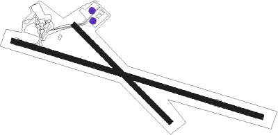
Biloela - Thangool
Airport details
| Country | Australia |
| State | Queensland |
| Region | YB |
| Airspace | Brisbane Ctr |
| Municipality | Banana Shire |
| Elevation | 644ft (196m) |
| Timezone | GMT +10 |
| Coordinates | -24.49333, 150.57666 |
| Magnetic var | |
| Type | land |
| Available since | X-Plane v10.40 |
| ICAO code | YTNG |
| IATA code | THG |
| FAA code | n/a |
Communication
| Thangool CTAF | 126.700 |
Nearby Points of Interest:
Kilbirnie Homestead
Nearby beacons
| code | identifier | dist | bearing | frequency |
|---|---|---|---|---|
| GLA | GLADSTONE VOR | 51 | 45° | 116.30 |
Instrument approach procedures
| runway | airway (heading) | route (dist, bearing) |
|---|---|---|
| RW10-Z | TN2WD (90°) | TN2WD 4300ft TN2WI (5mi, 44°) 3950ft |
| RW10-Z | TN2WE (110°) | TN2WE 4300ft TN2WI (5mi, 110°) 3950ft |
| RW10-Z | TN2WG (130°) | TN2WG 4300ft TN2WI (5mi, 182°) 3950ft |
| RNAV | TN2WI 3950ft TN2WF (5mi, 110°) 2360ft YTNG (6mi, 109°) 680ft TN2WH (2mi, 111°) (8555mi, 279°) 4300ft | |
| RW28-Z | TN2EA (271°) | TN2EA 4300ft TN2EI (5mi, 224°) 3870ft |
| RW28-Z | TN2EB (290°) | TN2EB 4300ft TN2EI (5mi, 290°) 3870ft |
| RW28-Z | TN2EC (310°) | TN2EC 4300ft TN2EI (5mi, 2°) 3870ft |
| RNAV | TN2EI 3870ft TN2EF (5mi, 290°) 2280ft YTNG (6mi, 290°) 690ft TN2EH (2mi, 289°) (8553mi, 279°) 4300ft |
Disclaimer
The information on this website is not for real aviation. Use this data with the X-Plane flight simulator only! Data taken with kind consent from X-Plane 12 source code and data files. Content is subject to change without notice.

