Shenzhen - Shenzhen Bao'an Intl
Airport details
| Country | China |
| State | Guangdong Province |
| Region | ZG |
| Airspace | Guangzhou Ctr |
| Municipality | Shenzhen |
| Elevation | 13ft (4m) |
| Timezone | GMT +8 |
| Coordinates | 22.63833, 113.81167 |
| Magnetic var | |
| Type | land |
| Available since | X-Plane v10.40 |
| ICAO code | ZGSZ |
| IATA code | SZX |
| FAA code | n/a |
Communication
| Shenzhen Bao'an Intl ATIS Arr | 126.850 |
| Shenzhen Bao'an Intl ATIS Dep | 127.450 |
| Shenzhen Bao'an Intl CLD | 121.950 |
| Shenzhen Bao'an Intl Ground Control East | 121.650 |
| Shenzhen Bao'an Intl Ground Control West | 121.800 |
| Shenzhen Bao'an Intl Tower 15/33 | 118.450 |
| Shenzhen Bao'an Intl Tower 16/34 | 130.350 |
| Shenzhen Bao'an Intl ZHUHAI Approach | 120.350 |
| Shenzhen Bao'an Intl ZHUHAI Approach | 124.250 |
Approach frequencies
| ILS-cat-I | RW34 | 109.1 | 18.00mi |
| ILS-cat-I | RW33 | 110.7 | 18.00mi |
| ILS-cat-I | RW15 | 111.3 | 18.00mi |
| ILS-cat-I | RW16 | 108.1 | 18.00mi |
| 3° GS | RW34 | 109.1 | 18.00mi |
| 3° GS | RW33 | 110.7 | 18.00mi |
| 3° GS | RW15 | 111.3 | 18.00mi |
| 3° GS | RW16 | 108.1 | 18.00mi |
Nearby Points of Interest:
Weiyuan Fort
-Fortified Structure at Ha Pak Nai
-Tat Tak Communal Hall
-Yu Kiu Ancestral Hall
-Tin Hau Temple, Fung Chi Tsuen
-Cheung Ancestral Hall, Shan Ha Tsuen
-Pun Uk
-Tang Tsing Lok Ancestral Hall
-Cheung Chun Yuen
-Tang Kwong U Ancestral Hall
-Lik Wing Tong Study Hall
-Bin Mo Bridge
-Chou Wong Yi Kung Study Hall
-Fanling Lodge
-Leung Ancestral Hall, Yuen Kong Tsuen
-Pat Heung Temple
-Residence of Ip Ting-zi
-Sing Lei Hap Gei Lime Kiln Factory
-301 & 303 Castle Peak Road
-Garden Centre
-Mei Ho House
-269-271 Yu Chau Street
-58 Pei Ho Street
-117-125 Nam Cheong Street
Runway info
Runway 16 / 34  | ||
| length | 3811m (12503ft) | |
| bearing | 151° / 331° | |
| width | 50m (164ft) | |
| surface | concrete | |
| blast zone | 120m (394ft) / 120m (394ft) | |
| Runway 15 / 33 | ||
| length | 3416m (11207ft) | |
| bearing | 151° / 331° | |
| width | 45m (148ft) | |
| surface | concrete | |
| blast zone | 60m (197ft) / 60m (197ft) | |
Airport layout
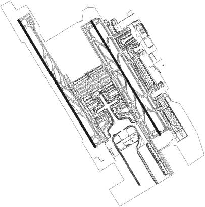
Taxiway locations
|
Parking locations
Nearby beacons
| code | identifier | dist | bearing | frequency |
|---|---|---|---|---|
| SHK | SHEKOU VOR/DME | 9.9 | 147° | 115.90 |
| GLN | GUANLAN VOR/DME | 12.9 | 72° | 112 |
| NLG | NANLANG VOR/DME | 15.2 | 247° | 117.70 |
| LKC | LUNG KWU CHAU VOR/DME | 16 | 164° | 113.20 |
| SMT | SIU MO TO VOR/DME | 20.3 | 150° | 114.80 |
| SL | SHA LO WAN (HONG KONG) NDB | 21.5 | 165° | 268 |
| ZAO | JIUZHOU VOR/DME | 25.9 | 207° | 117.20 |
| SC | STONECUTTERS (HONG KONG) NDB | 26.1 | 135° | 236 |
| SHL | SHILONG VOR/DME | 27.3 | 5° | 115.70 |
| CH | CHAU DME | 27.9 | 152° | 112.30 |
| RW | HONG KONG NDB | 28.1 | 129° | 377 |
| CC | HONG KONG CHEUNG NDB | 28.8 | 154° | 360 |
| ZUH | LIANSHENGWEI VOR/DME | 31.5 | 220° | 116.70 |
| MCU | MACAO VOR/DME | 32.4 | 203° | 116.40 |
| TD | TUNG LUNG VOR/DME | 35.5 | 129° | 116.10 |
| TH | TATHONG POINT VOR_DME VOR/DME | 35.7 | 130° | 115.50 |
| CEN | CENCUN VOR/DME | 37.7 | 322° | 114.60 |
| POU | PINGZHOU VOR/DME | 41.4 | 302° | 114.10 |
| FO | GUANGZHOU NDB | 43.5 | 311° | 410 |
| U | SANZAO NDB | 46.5 | 215° | 272 |
| UJ | GAOLAN NDB | 51.8 | 216° | 204 |
| CON | CONGHUA VOR/DME | 58.3 | 347° | 113 |
Departure and arrival routes
| Transition altitude | 8858ft |
| Transition level | 11811ft |
| SID end points | distance | outbound heading | |
|---|---|---|---|
| RW15 | |||
| IDU1WD, IDU9WD | 17mi | 28° | |
| SLS9WD, SLS1WD | 28mi | 56° | |
| OVG9WD, OVG2WD, OVG1WD | 53mi | 81° | |
| LKC9WD, LKC1WD | 16mi | 164° | |
| SIE1WD, SIE3WD, SIE9WD | 42mi | 202° | |
| TOM3WD, TOM9WD, TOM2WD, TOM1WD | 84mi | 238° | |
| MIP9WD, MIP1WD | 17mi | 346° | |
| RW16 | |||
| IDU1XD, IDU9XD | 17mi | 28° | |
| SLS1XD, SLS9XD | 28mi | 56° | |
| OVG9XD, OVG1XD, OVG2XD | 53mi | 81° | |
| LKC1XD, LKC9XD | 16mi | 164° | |
| SIE9XD, SIE1XD, SIE3XD | 42mi | 202° | |
| TOM9XD, TOM3XD, TOM2XD, TOM1XD | 84mi | 238° | |
| MIP9XD, MIP8XD, MIP1XD | 17mi | 346° | |
| RW33 | |||
| IDU1YD, IDU9YD | 17mi | 28° | |
| SLS9YD, SLS1YD | 28mi | 56° | |
| OVG9YD, OVG8YD, OVG1YD | 53mi | 81° | |
| LKC9YD, LKC1YD | 16mi | 164° | |
| SIE1YD, SIE3YD, SIE9YD | 42mi | 202° | |
| TOM3YD, TOM9YD, TOM2YD, TOM1YD | 84mi | 238° | |
| MIP9YD, MIP1YD | 17mi | 346° | |
| RW34 | |||
| IDU1ZD, IDU9ZD | 17mi | 28° | |
| SLS9ZD, SLS1ZD | 28mi | 56° | |
| OVG9ZD, OVG8ZD, OVG1ZD | 53mi | 81° | |
| LKC9ZD, LKC1ZD | 16mi | 164° | |
| SIE1ZD, SIE3ZD, SIE9ZD | 42mi | 202° | |
| TOM3ZD, TOM2ZD, TOM1ZD, TOM9ZD | 84mi | 238° | |
| MIP1ZD, MIP9ZD | 17mi | 346° | |
| STAR starting points | distance | inbound heading | |
|---|---|---|---|
| RW15 | |||
| LAN1XA, LAN2XA, LAN8XA, LAN9XA | 74.8 | 37° | |
| LOV9XA, LOV8XA, LOV2XA, LOV1XA | 87.3 | 54° | |
| SAR9XA, SAR3XA, SAR2XA, SAR1XA | 41.4 | 122° | |
| SAR8XA | 23.3 | 127° | |
| OVG9XA, OVG1XA | 52.7 | 261° | |
| BEK1XA, BEK9XA | 18.7 | 286° | |
| RW16 | |||
| LAN9XA, LAN8XA, LAN2XA, LAN1XA | 74.8 | 37° | |
| LOV1XA, LOV2XA, LOV8XA, LOV9XA | 87.3 | 54° | |
| SAR9XA, SAR3XA, SAR2XA, SAR1XA | 41.4 | 122° | |
| SAR8XA | 23.3 | 127° | |
| OVG9XA, OVG1XA | 52.7 | 261° | |
| BEK1XA, BEK9XA | 18.7 | 286° | |
| RW33 | |||
| LAN9ZA, LAN8ZA, LAN3ZA, LAN2ZA, LAN1ZA, LAN0ZA | 74.8 | 37° | |
| LOV8ZA, LOV3ZA, LOV2ZA, LOV1ZA, LOV0ZA, LOV9ZA | 87.3 | 54° | |
| SAR1ZA, SAR2ZA, SAR9ZA | 41.4 | 122° | |
| SAR8ZA | 23.3 | 127° | |
| OVG1ZA, OVG9ZA, OVG2ZA | 52.7 | 261° | |
| BEK1ZA, BEK2ZA, BEK9ZA | 18.7 | 286° | |
| RW34 | |||
| LAN3ZA, LAN2ZA, LAN1ZA, LAN0ZA, LAN9ZA, LAN8ZA | 74.8 | 37° | |
| LOV3ZA, LOV1ZA, LOV8ZA, LOV9ZA, LOV0ZA, LOV2ZA | 87.3 | 54° | |
| SAR9ZA, SAR2ZA, SAR1ZA | 41.4 | 122° | |
| SAR8ZA | 23.3 | 127° | |
| OVG1ZA, OVG2ZA, OVG9ZA | 52.7 | 261° | |
| BEK2ZA, BEK9ZA, BEK1ZA | 18.7 | 286° | |
Holding patterns
| STAR name | hold at | type | turn | heading* | altitude | leg | speed limit |
|---|---|---|---|---|---|---|---|
| BEK1XA | GLN | NDB | right | 86 (266)° | > 4930ft | 1.0min timed | 205 |
| BEK1ZA | GLN | NDB | right | 86 (266)° | > 4930ft | 1.0min timed | 205 |
| BEK9XA | GLN | NDB | right | 86 (266)° | > 4930ft | 1.0min timed | 205 |
| LAN1XA | NLG | NDB | left | 350 (170)° | > 3940ft | 1.0min timed | 205 |
| LAN1ZA | NLG | NDB | left | 350 (170)° | > 3940ft | 1.0min timed | 205 |
| LAN2XA | NLG | NDB | left | 350 (170)° | > 3940ft | 1.0min timed | 205 |
| LAN3ZA | NLG | NDB | left | 350 (170)° | > 3940ft | 1.0min timed | 205 |
| LAN8XA | GURIN | VHF | right | 257 (77)° | > 8860ft | 1.0min timed | ICAO rules |
| LAN8ZA | GURIN | VHF | right | 257 (77)° | > 8860ft | 1.0min timed | ICAO rules |
| LAN9XA | NLG | NDB | left | 350 (170)° | > 3940ft | 1.0min timed | 205 |
| LOV1XA | NLG | NDB | left | 350 (170)° | > 3940ft | 1.0min timed | 205 |
| LOV1ZA | NLG | NDB | left | 350 (170)° | > 3940ft | 1.0min timed | 205 |
| LOV2XA | NLG | NDB | left | 350 (170)° | > 3940ft | 1.0min timed | 205 |
| LOV3ZA | NLG | NDB | left | 350 (170)° | > 3940ft | 1.0min timed | 205 |
| LOV8XA | GURIN | VHF | right | 257 (77)° | > 8860ft | 1.0min timed | ICAO rules |
| LOV8ZA | GURIN | VHF | right | 257 (77)° | > 8860ft | 1.0min timed | ICAO rules |
| LOV9XA | NLG | NDB | left | 350 (170)° | > 3940ft | 1.0min timed | 205 |
| OVG1XA | GLN | NDB | right | 86 (266)° | > 4930ft | 1.0min timed | 205 |
| OVG1ZA | GLN | NDB | right | 86 (266)° | > 4930ft | 1.0min timed | 205 |
| OVG9XA | GLN | NDB | right | 86 (266)° | > 4930ft | 1.0min timed | 205 |
| OVG9ZA | GLN | NDB | right | 86 (266)° | > 4930ft | 1.0min timed | 205 |
| SAR1XA | NLG | NDB | left | 350 (170)° | > 3940ft | 1.0min timed | 205 |
| SAR1ZA | NLG | NDB | left | 350 (170)° | > 3940ft | 1.0min timed | 205 |
| SAR2ZA | NLG | NDB | left | 350 (170)° | > 3940ft | 1.0min timed | 205 |
| SAR3XA | NLG | NDB | left | 350 (170)° | > 3940ft | 1.0min timed | 205 |
| SAR9ZA | NLG | NDB | left | 350 (170)° | > 3940ft | 1.0min timed | 205 |
| *) magnetic outbound (inbound) holding course | |||||||
Disclaimer
The information on this website is not for real aviation. Use this data with the X-Plane flight simulator only! Data taken with kind consent from X-Plane 12 source code and data files. Content is subject to change without notice.