Zhengzhou - Zhengzhou Xinzheng Intl'
Airport details
| Country | China |
| State | Henan |
| Region | ZH |
| Airspace | Wuhan Ctr |
| Municipality | Xinmi |
| Elevation | 496ft (151m) |
| Timezone | GMT +8 |
| Coordinates | 34.51833, 113.84000 |
| Magnetic var | |
| Type | land |
| Available since | X-Plane v10.40 |
| ICAO code | ZHCC |
| IATA code | CGO |
| FAA code | n/a |
Communication
| Zhengzhou Xinzheng Intl' ATIS | 128.450 |
| Zhengzhou Xinzheng Intl' Zhengzhou Delivery | 121.800 |
| Zhengzhou Xinzheng Intl' Zhengzhou Apron (North) | 121.700 |
| Zhengzhou Xinzheng Intl' Zhengzhou Ground (South) | 121.600 |
| Zhengzhou Xinzheng Intl' Zhengzhou Ground (North) | 121.900 |
| Zhengzhou Xinzheng Intl' Zhengzhou Apron (South) | 121.975 |
| Zhengzhou Xinzheng Intl' Zhengzhou Tower (North) | 118.075 |
| Zhengzhou Xinzheng Intl' Zhengzhou Tower (South) | 118.300 |
| Zhengzhou Xinzheng Intl' Zhengzhou Tower STBY | 118.850 |
| Zhengzhou Xinzheng Intl' Zhengzhou Approach STBY | 124.200 |
| Zhengzhou Xinzheng Intl' Zhengzhou Approach 01 | 120.275 |
| Zhengzhou Xinzheng Intl' Zhengzhou Approach 02 | 126.350 |
| Zhengzhou Xinzheng Intl' Zhengzhou Approach 03 | 124.825 |
Approach frequencies
| ILS-cat-II | RW12L | 108.5 | 18.00mi |
| ILS-cat-I | RW30L | 109.3 | 18.00mi |
| ILS-cat-I | RW12R | 110.3 | 18.00mi |
| ILS-cat-I | RW30R | 110.7 | 18.00mi |
| 3° GS | RW30L | 109.3 | 18.00mi |
| 3° GS | RW12R | 110.3 | 18.00mi |
| 3° GS | RW12L | 108.5 | 18.00mi |
| 3° GS | RW30R | 110.7 | 18.00mi |
Nearby Points of Interest:
Site of Capital of Kingdom Zheng and Han
-Shang City Ruins
-Dahuting
-Wenfeng Pagoda
-Xudu
Runway info
Runway 12R / 30L  | ||
| length | 3403m (11165ft) | |
| bearing | 109° / 289° | |
| width | 45m (148ft) | |
| surface | asphalt | |
| blast zone | 60m (197ft) / 60m (197ft) | |
| Runway 12L / 30R | ||
| length | 3603m (11821ft) | |
| bearing | 109° / 289° | |
| width | 60m (197ft) | |
| surface | concrete | |
| blast zone | 120m (394ft) / 120m (394ft) | |
Airport layout
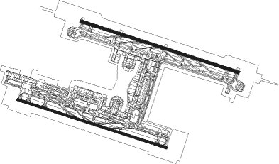
Taxiway locations
Parking locations
|
Nearby beacons
| code | identifier | dist | bearing | frequency |
|---|---|---|---|---|
| CGO | XINZHENG VOR/DME | 0.1 | 90° | 114.50 |
| A | XINZHENG (ZHENGZHOU) NDB | 1.4 | 106° | 211 |
| F | XINZHENG (ZHENGZHOU) NDB | 1.4 | 291° | 228 |
| DWS | WEISHI VOR/DME | 16.6 | 129° | 117.40 |
| DZY | ZHONGYUAN VOR/DME | 19 | 306° | 116.80 |
| ZHO | ZHOUKOU VOR/DME | 65.3 | 136° | 115.50 |
Departure and arrival routes
| Transition altitude | 9842ft |
| Transition level | 11811ft |
| SID end points | distance | outbound heading | |
|---|---|---|---|
| RW12L | |||
| GUK9W, GUK1W | 61mi | 25° | |
| OKT9W, OKT1W | 36mi | 95° | |
| RUM1W, RUM9W | 77mi | 139° | |
| DUD1W, DUD9W | 90mi | 146° | |
| NOP9W, NOP1W | 59mi | 338° | |
| PAD9W, PAD1W | 84mi | 338° | |
| RW12R | |||
| GUK1X, GUK9X | 61mi | 25° | |
| OKT9X, OKT1X | 36mi | 95° | |
| RUM9X, RUM1X | 77mi | 139° | |
| DUD9X, DUD1X | 90mi | 146° | |
| NOP1X, NOP9X | 59mi | 338° | |
| PAD9X, PAD1X | 84mi | 338° | |
| RW30L | |||
| GUK1Y, GUK9Y | 61mi | 25° | |
| OKT9Y, OKT1Y | 36mi | 95° | |
| RUM1Y, RUM9Y | 77mi | 139° | |
| DUD1Y, DUD9Y | 90mi | 146° | |
| NOP1Y, NOP9Y | 59mi | 338° | |
| PAD1Y, PAD9Y | 84mi | 338° | |
| RW30R | |||
| GUK9Z, GUK8Z, GUK2Z, GUK1Z | 61mi | 25° | |
| OKT9Z, OKT1Z | 36mi | 95° | |
| RUM1Z, RUM9Z | 77mi | 139° | |
| DUD1Z, DUD9Z | 90mi | 146° | |
| NOP1Z, NOP9Z | 59mi | 338° | |
| PAD9Z, PAD8Z, PAD2Z, PAD1Z | 84mi | 338° | |
| STAR starting points | distance | inbound heading | |
|---|---|---|---|
| RW12 (ALL) | |||
| NOP8U, NOP9U, NOP7U, NOP6U, NOP2U, NOP1U | 58.5 | 158° | |
| LKB6U, LKB9U, LKB2U, LKB1U | 63.5 | 202° | |
| VET1U, VET2U, VET6U, VET8U, VET9U | 68.7 | 298° | |
| UNT9U, UNT8U, UNT6U | 67.1 | 311° | |
| IGM9U, IGM6U, IGM1U, IGM5U | 80.0 | 333° | |
| RW12L | |||
| NOP10U | 58.5 | 158° | |
| LKB10U | 63.5 | 202° | |
| VET11U, VET10U | 68.7 | 298° | |
| UNT11U, UNT10U | 67.1 | 311° | |
| IGM10U | 80.0 | 333° | |
| RW30 (ALL) | |||
| NOP9V, NOP8V, NOP6V, NOP2V, NOP1V | 58.5 | 158° | |
| LKB2V, LKB6V, LKB8V, LKB9V, LKB1V | 63.5 | 202° | |
| VET1V, VET6V, VET9V | 68.7 | 298° | |
| UNT9V, UNT6V, UNT5V | 67.1 | 311° | |
| IGM1V, IGM5V, IGM6V, IGM9V | 80.0 | 333° | |
Holding patterns
| STAR name | hold at | type | turn | heading* | altitude | leg | speed limit |
|---|---|---|---|---|---|---|---|
| IGM10U | CC571 | VHF | left | 169 (349)° | > 11800ft | 1.0min timed | 230 |
| IGM1U | CGO40 | VHF | left | 170 (350)° | > 11800ft | 1.0min timed | 230 |
| IGM1U | D296Y | VHF | left | 116 (296)° | 3940ft - 7880ft | 1.0min timed | 205 |
| IGM1V | D160P | VHF | left | 160 (340)° | > 6890ft | 1.0min timed | 205 |
| IGM5U | CC571 | VHF | left | 169 (349)° | > 11800ft | 1.0min timed | 230 |
| IGM6U | CC571 | VHF | left | 169 (349)° | > 11800ft | 1.0min timed | 230 |
| IGM6V | CC642 | VHF | right | 189 (9)° | > 8860ft | 1.0min timed | 205 |
| IGM9U | CC409 | VHF | left | 116 (296)° | 3940ft - 7880ft | 1.0min timed | 205 |
| IGM9U | CC571 | VHF | left | 169 (349)° | > 11800ft | 1.0min timed | 230 |
| IGM9V | CC538 | VHF | left | 158 (338)° | > 6890ft | 1.0min timed | 205 |
| LKB1U | DZY | NDB | right | 51 (231)° | > 4930ft | 1.0min timed | 205 |
| LKB1V | DWS28 | VHF | left | 296 (116)° | > 7880ft | 1.0min timed | 205 |
| LKB2U | D296Y | VHF | left | 116 (296)° | 3940ft - 7880ft | 1.0min timed | 205 |
| LKB2V | DZY34 | VHF | right | 296 (116)° | > 5910ft | 1.0min timed | 205 |
| LKB6V | DZY | NDB | right | 51 (231)° | > 4930ft | 1.0min timed | 205 |
| LKB8V | CC527 | VHF | right | 296 (116)° | > 5910ft | 1.0min timed | 205 |
| LKB9U | DZY | NDB | right | 51 (231)° | > 4930ft | 1.0min timed | 205 |
| LKB9V | CC305 | VHF | left | 296 (116)° | > 7880ft | 1.0min timed | 205 |
| LKB9V | DZY | NDB | right | 51 (231)° | > 4930ft | 1.0min timed | 205 |
| NOP10U | CC315 | VHF | right | 345 (165)° | > 11800ft | 1.0min timed | 230 |
| NOP1U | CGO36 | VHF | right | 345 (165)° | > 11800ft | 1.0min timed | 230 |
| NOP1U | DZY | NDB | right | 51 (231)° | > 4930ft | 1.0min timed | 205 |
| NOP1V | CGO36 | VHF | right | 345 (165)° | > 11800ft | 1.0min timed | 230 |
| NOP1V | DWS28 | VHF | left | 296 (116)° | > 7880ft | 1.0min timed | 205 |
| NOP2U | CGO36 | VHF | right | 345 (165)° | > 11800ft | 1.0min timed | 230 |
| NOP2U | D296Y | VHF | left | 116 (296)° | 3940ft - 7880ft | 1.0min timed | 205 |
| NOP2V | CGO36 | VHF | right | 345 (165)° | > 11800ft | 1.0min timed | 230 |
| NOP2V | DZY34 | VHF | right | 296 (116)° | > 5910ft | 1.0min timed | 205 |
| NOP6U | CC315 | VHF | right | 345 (165)° | > 11800ft | 1.0min timed | 230 |
| NOP6V | CC315 | VHF | right | 345 (165)° | > 11800ft | 1.0min timed | 230 |
| NOP6V | DZY | NDB | right | 51 (231)° | > 4930ft | 1.0min timed | 205 |
| NOP7U | CC315 | VHF | right | 345 (165)° | > 11800ft | 1.0min timed | 230 |
| NOP7U | CC409 | VHF | left | 116 (296)° | 3940ft - 7880ft | 1.0min timed | 205 |
| NOP8U | CC315 | VHF | right | 345 (165)° | > 11800ft | 1.0min timed | 230 |
| NOP8U | CC584 | VHF | left | 116 (296)° | > 4930ft | 1.0min timed | 205 |
| NOP8U | DZY | NDB | right | 51 (231)° | > 4930ft | 1.0min timed | 205 |
| NOP8V | CC315 | VHF | right | 345 (165)° | > 11800ft | 1.0min timed | 230 |
| NOP8V | CC527 | VHF | right | 296 (116)° | > 5910ft | 1.0min timed | 205 |
| NOP9U | CC315 | VHF | right | 345 (165)° | > 11800ft | 1.0min timed | 230 |
| NOP9U | DZY | NDB | right | 51 (231)° | > 4930ft | 1.0min timed | 205 |
| NOP9V | CC305 | VHF | left | 296 (116)° | > 7880ft | 1.0min timed | 205 |
| NOP9V | CC315 | VHF | right | 345 (165)° | > 11800ft | 1.0min timed | 230 |
| NOP9V | DZY | NDB | right | 51 (231)° | > 4930ft | 1.0min timed | 205 |
| UNT10U | OGOVI | VHF | right | 167 (347)° | > 11800ft | 1.0min timed | 230 |
| UNT11U | OGOVI | VHF | right | 167 (347)° | > 11800ft | 1.0min timed | 230 |
| UNT6U | OGOVI | VHF | right | 167 (347)° | > 11800ft | 1.0min timed | 230 |
| UNT6V | CC642 | VHF | right | 189 (9)° | > 8860ft | 1.0min timed | 205 |
| UNT8U | CC584 | VHF | left | 116 (296)° | > 4930ft | 1.0min timed | 205 |
| UNT8U | DZY | NDB | right | 51 (231)° | > 4930ft | 1.0min timed | 205 |
| UNT8U | OGOVI | VHF | right | 167 (347)° | > 11800ft | 1.0min timed | 230 |
| UNT9U | CC409 | VHF | left | 116 (296)° | 3940ft - 7880ft | 1.0min timed | 205 |
| UNT9U | OGOVI | VHF | right | 167 (347)° | > 11800ft | 1.0min timed | 230 |
| UNT9V | GUTUS | VHF | left | 118 (298)° | > 11800ft | 1.0min timed | 230 |
| VET10U | OGOVI | VHF | right | 167 (347)° | > 11800ft | 1.0min timed | 230 |
| VET11U | OGOVI | VHF | right | 167 (347)° | > 11800ft | 1.0min timed | 230 |
| VET1U | D296Y | VHF | left | 116 (296)° | 3940ft - 7880ft | 1.0min timed | 205 |
| VET1U | OGOVI | VHF | right | 167 (347)° | > 11800ft | 1.0min timed | 230 |
| VET1V | OGOVI | VHF | right | 167 (347)° | > 11800ft | 1.0min timed | 230 |
| VET2U | D116I | VHF | left | 116 (296)° | > 4930ft | 1.0min timed | 205 |
| VET2U | DZY | NDB | right | 51 (231)° | > 4930ft | 1.0min timed | 205 |
| VET2U | OGOVI | VHF | right | 167 (347)° | > 11800ft | 1.0min timed | 230 |
| VET6U | OGOVI | VHF | right | 167 (347)° | > 11800ft | 1.0min timed | 230 |
| VET8U | CC584 | VHF | left | 116 (296)° | > 4930ft | 1.0min timed | 205 |
| VET8U | DZY | NDB | right | 51 (231)° | > 4930ft | 1.0min timed | 205 |
| VET8U | OGOVI | VHF | right | 167 (347)° | > 11800ft | 1.0min timed | 230 |
| VET9U | CC409 | VHF | left | 116 (296)° | 3940ft - 7880ft | 1.0min timed | 205 |
| VET9U | OGOVI | VHF | right | 167 (347)° | > 11800ft | 1.0min timed | 230 |
| VET9V | GUTUS | VHF | left | 118 (298)° | > 11800ft | 1.0min timed | 230 |
| *) magnetic outbound (inbound) holding course | |||||||
Disclaimer
The information on this website is not for real aviation. Use this data with the X-Plane flight simulator only! Data taken with kind consent from X-Plane 12 source code and data files. Content is subject to change without notice.