Nanjing - Nanjing Lukou Intl'
Airport details
| Country | China |
| State | Jiangsu |
| Region | ZS |
| Airspace | Shanghai Ctr |
| Municipality | Nanjing City |
| Elevation | 47ft (14m) |
| Timezone | GMT +8 |
| Coordinates | 31.74333, 118.86333 |
| Magnetic var | |
| Type | land |
| Available since | X-Plane v10.40 |
| ICAO code | ZSNJ |
| IATA code | NKG |
| FAA code | n/a |
Communication
| Nanjing Lukou Intl' ATIS | 126.250 |
| Nanjing Lukou Intl' Nanjing Delivery | 121.900 |
| Nanjing Lukou Intl' Nanjing Apron (North) | 121.975 |
| Nanjing Lukou Intl' Nanjing Apron (South) | 121.800 |
| Nanjing Lukou Intl' Nanjing Ground (North) | 121.700 |
| Nanjing Lukou Intl' Nanjing Ground (South) | 121.600 |
| Nanjing Lukou Intl' Nanjing Tower (North) | 118.850 |
| Nanjing Lukou Intl' Nanjing Tower (South) | 118.475 |
| Nanjing Lukou Intl' Tower and Ground Standby | 118.225 |
| Nanjing Lukou Intl' Nanjing Approach 02 | 126.550 |
| Nanjing Lukou Intl' Approach Standby | 120.350 |
| Nanjing Lukou Intl' Nanjing Approach 03 | 119.675 |
| Nanjing Lukou Intl' Nanjing Approach 04 | 121.300 |
| Nanjing Lukou Intl' Nanjing Approach 01 | 119.250 |
| Nanjing Lukou Intl' Nanjing Approach 05 | 119.900 |
Approach frequencies
| ILS-cat-II | RW07 | 108.7 | 18.00mi |
| ILS-cat-I | RW24 | 110.9 | 18.00mi |
| ILS-cat-I | RW06 | 110.3 | 18.00mi |
| ILS-cat-I | RW25 | 111.3 | 18.00mi |
| 3° GS | RW24 | 110.9 | 18.00mi |
| 3° GS | RW06 | 110.3 | 18.00mi |
| 3° GS | RW25 | 111.3 | 18.00mi |
| 3° GS | RW07 | 108.7 | 18.00mi |
Nearby Points of Interest:
Two Mausoleums of the Southern Tang Dynasty
-Tomb of the King of Boni
-Ming Palace
-John Rabe House
-Tomb of Chang Yuchun
-Site of National Central University
-Tomb of Wu Zhen
-Nanjing Bell Tower
-Tomb of Li Wenzhong
-Yangshan Quarry
-Tomb of Li Bai
-Longchang Temple
Runway info
Runway 06 / 24  | ||
| length | 3599m (11808ft) | |
| bearing | 62° / 242° | |
| width | 45m (148ft) | |
| surface | asphalt | |
| blast zone | 60m (197ft) / 60m (197ft) | |
| Runway 07 / 25 | ||
| length | 3604m (11824ft) | |
| bearing | 62° / 242° | |
| width | 60m (197ft) | |
| surface | concrete | |
| blast zone | 120m (394ft) / 120m (394ft) | |
Airport layout
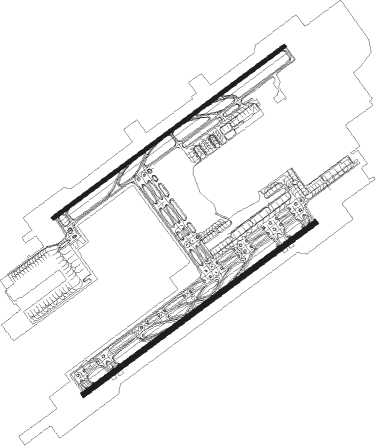
Taxiway locations
Parking locations
|
Nearby beacons
| code | identifier | dist | bearing | frequency |
|---|---|---|---|---|
| NJL | LUKOU VOR/DME | 1.3 | 63° | 113.60 |
| Z | LUKOU NDB | 2.3 | 217° | 420 |
| MLJ | MOLING VOR/DME | 6.1 | 355° | 117.05 |
| SNQ | SHIQIU VOR/DME | 6.5 | 121° | 115.75 |
| ID | XIAODANYANG NDB | 8.7 | 242° | 440 |
| GT | QUNLI NDB | 10.1 | 77° | 276 |
| A | DAJIAOCHANG NDB | 14.9 | 344° | 511 |
| ZJ | BENNIU NDB | 44.8 | 77° | 217 |
| CZO | CHANGZHOU VOR/DME | 47.7 | 79° | 113.80 |
| OF | BANTAJI NDB | 57.7 | 343° | 340 |
| SJD | YANGZHOU VOR/DME | 65 | 47° | 113.10 |
Departure and arrival routes
| Transition altitude | 9842ft |
| Transition level | 11811ft |
| SID end points | distance | outbound heading | |
|---|---|---|---|
| RW06 | |||
| ESB11D, ESB61X | 42mi | 99° | |
| TES61X, TES11D | 42mi | 136° | |
| HFE61X, HFE11D | 80mi | 271° | |
| RW07 | |||
| ESB21D, ESB71X | 42mi | 99° | |
| TES71X, TES21D | 42mi | 136° | |
| HFE71X, HFE21D | 80mi | 271° | |
| RW24 | |||
| ESB12D, ESB42X | 42mi | 99° | |
| TES42X, TES12D | 42mi | 136° | |
| HFE42X, HFE12D | 80mi | 271° | |
| RW25 | |||
| ESB22D, ESB52X | 42mi | 99° | |
| TES22D, TES52X | 42mi | 136° | |
| HFE22D, HFE52X | 80mi | 271° | |
| STAR starting points | distance | inbound heading | |
|---|---|---|---|
| RW06 | |||
| HFE11A, HFE61F | 79.7 | 91° | |
| ESB11A, ESB61F | 42.0 | 279° | |
| KAK11A, KAK61F | 100.3 | 314° | |
| RW07 | |||
| HFE71F, HFE21A | 79.7 | 91° | |
| ESB71F, ESB21A | 42.0 | 279° | |
| KAK21A, KAK71F | 100.3 | 314° | |
| RW24 | |||
| HFE44F, HFE42F, HFE12A | 79.7 | 91° | |
| ESB42F, ESB12A | 42.0 | 279° | |
| KAK12A, KAK42F | 100.3 | 314° | |
| RW25 | |||
| HFE54F, HFE52F, HFE22A | 79.7 | 91° | |
| ESB52F, ESB22A | 42.0 | 279° | |
| KAK52F, KAK22A | 100.3 | 314° | |
Holding patterns
| STAR name | hold at | type | turn | heading* | altitude | leg | speed limit |
|---|---|---|---|---|---|---|---|
| ESB11A | SNQ | NDB | left | 62 (242)° | > 6890ft | 1.0min timed | 215 |
| ESB21A | SNQ | NDB | left | 62 (242)° | > 6890ft | 1.0min timed | 215 |
| ESB61F | SNQ | NDB | left | 62 (242)° | > 6890ft | 1.0min timed | 215 |
| ESB71F | SNQ | NDB | left | 62 (242)° | > 6890ft | 1.0min timed | 215 |
| HFE11A | SNQ28 | VHF | left | 273 (93)° | > 4930ft | 1.0min timed | 215 |
| HFE12A | MLJ | NDB | right | 242 (62)° | > 6890ft | 1.0min timed | 215 |
| HFE21A | SNQ28 | VHF | left | 273 (93)° | > 4930ft | 1.0min timed | 215 |
| HFE22A | MLJ | NDB | right | 242 (62)° | > 6890ft | 1.0min timed | 215 |
| HFE42F | NJ216 | VHF | right | 242 (62)° | > 5910ft | 1.0min timed | 215 |
| HFE44F | MLJ | NDB | right | 242 (62)° | > 6890ft | 1.0min timed | 215 |
| HFE52F | NJ216 | VHF | right | 242 (62)° | > 5910ft | 1.0min timed | 215 |
| HFE54F | MLJ | NDB | right | 242 (62)° | > 6890ft | 1.0min timed | 215 |
| HFE61F | NJ114 | VHF | left | 275 (95)° | > 4930ft | 1.0min timed | 215 |
| HFE71F | NJ114 | VHF | left | 275 (95)° | > 4930ft | 1.0min timed | 215 |
| KAK11A | SNQ | NDB | left | 62 (242)° | > 6890ft | 1.0min timed | 215 |
| KAK12A | SNQ | NDB | left | 62 (242)° | > 6890ft | 1.0min timed | 215 |
| KAK21A | SNQ | NDB | left | 62 (242)° | > 6890ft | 1.0min timed | 215 |
| KAK22A | SNQ | NDB | left | 62 (242)° | > 6890ft | 1.0min timed | 215 |
| KAK61F | SNQ | NDB | left | 62 (242)° | > 6890ft | 1.0min timed | 215 |
| KAK71F | SNQ | NDB | left | 62 (242)° | > 6890ft | 1.0min timed | 215 |
| OF11A | MLJ | NDB | right | 242 (62)° | > 6890ft | 1.0min timed | 215 |
| OF12A | MLJ | NDB | right | 242 (62)° | > 6890ft | 1.0min timed | 215 |
| OF21A | MLJ | NDB | right | 242 (62)° | > 6890ft | 1.0min timed | 215 |
| OF22A | MLJ | NDB | right | 242 (62)° | > 6890ft | 1.0min timed | 215 |
| OF42F | MLJ | NDB | right | 242 (62)° | > 6890ft | 1.0min timed | 215 |
| OF42F | NJ216 | VHF | right | 242 (62)° | > 5910ft | 1.0min timed | 215 |
| OF44F | MLJ | NDB | right | 242 (62)° | > 6890ft | 1.0min timed | 215 |
| OF52F | MLJ | NDB | right | 242 (62)° | > 6890ft | 1.0min timed | 215 |
| OF52F | NJ216 | VHF | right | 242 (62)° | > 5910ft | 1.0min timed | 215 |
| OF54F | MLJ | NDB | right | 242 (62)° | > 6890ft | 1.0min timed | 215 |
| OF61F | NJ116 | VHF | left | 62 (242)° | > 6890ft | 1.0min timed | 215 |
| OF71F | NJ116 | VHF | left | 62 (242)° | > 6890ft | 1.0min timed | 215 |
| ZJ11A | SNQ | NDB | left | 62 (242)° | > 6890ft | 1.0min timed | 215 |
| ZJ21A | SNQ | NDB | left | 62 (242)° | > 6890ft | 1.0min timed | 215 |
| ZJ61F | SNQ | NDB | left | 62 (242)° | > 6890ft | 1.0min timed | 215 |
| ZJ71F | SNQ | NDB | left | 62 (242)° | > 6890ft | 1.0min timed | 215 |
| *) magnetic outbound (inbound) holding course | |||||||
Disclaimer
The information on this website is not for real aviation. Use this data with the X-Plane flight simulator only! Data taken with kind consent from X-Plane 12 source code and data files. Content is subject to change without notice.