Shanghai - Shanghai Pudong
Airport details
| Country | China |
| State | Shanghai |
| Region | ZS |
| Airspace | Shanghai Ctr |
| Elevation | 12ft (4m) |
| Timezone | GMT +8 |
| Coordinates | 31.14500, 121.79333 |
| Magnetic var | |
| Type | land |
| Available since | X-Plane v10.40 |
| ICAO code | ZSPD |
| IATA code | PVG |
| FAA code | n/a |
Communication
| Shanghai Pudong ATIS | 127.850 |
| Shanghai Pudong ATIS | 131.450 |
| Shanghai Pudong CLR DEL | 121.950 |
| Shanghai Pudong Ground Control EAST | 121.800 |
| Shanghai Pudong Ground Control WEST | 121.700 |
| Shanghai Pudong Tower WEST | 118.800 |
| Shanghai Pudong Tower EAST | 118.400 |
| Shanghai Pudong Shanghai Approach Control | 125.400 |
| Shanghai Pudong Shanghai Approach Control | 125.850 |
| Shanghai Pudong Shanghai Approach Control | 127.750 |
| Shanghai Pudong Shanghai Approach Control | 119.750 |
| Shanghai Pudong Shanghai Approach Control | 120.300 |
| Shanghai Pudong Shanghai Approach Control | 123.800 |
| Shanghai Pudong Shanghai Approach Control | 126.650 |
| Shanghai Pudong Shanghai Approach Control | 119.200 |
| Shanghai Pudong Shanghai Approach Control | 120.650 |
| Shanghai Pudong Shanghai Approach Control | 124.050 |
| Shanghai Pudong Shanghai Approach Control | 126.300 |
| Shanghai Pudong Shanghai Approach Control | 128.050 |
| Shanghai Pudong Shanghai Approach Control | 121.100 |
Approach frequencies
| ILS-cat-III | RW34L | 108.3 | 18.00mi |
| ILS-cat-II | RW35R | 111.9 | 18.00mi |
| ILS-cat-II | RW17L | 110.7 | 18.00mi |
| ILS-cat-I | RW34R | 108.9 | 18.00mi |
| ILS-cat-I | RW16R | 108.7 | 18.00mi |
| ILS-cat-I | RW35L | 108.1 | 18.00mi |
| ILS-cat-I | RW17R | 111.1 | 18.00mi |
| ILS-cat-I | RW16L | 111.5 | 18.00mi |
| 3° GS | RW16R | 108.7 | 18.00mi |
| 3° GS | RW17L | 110.7 | 18.00mi |
| 3° GS | RW17R | 111.1 | 18.00mi |
| 3° GS | RW16L | 111.5 | 18.00mi |
| 3° GS | RW34R | 108.9 | 18.00mi |
| 3° GS | RW34L | 108.3 | 18.00mi |
| 3° GS | RW35L | 108.1 | 18.00mi |
| 3° GS | RW35R | 111.9 | 18.00mi |
Nearby Points of Interest:
Former Residence of Zhang Wentian
-Yangshupu Power Plant
-Asia Building
-Bank of Taiwan Building
-Bank of China Building
-Gutzlaff Signal Tower
-Yongnian Mansion
-Shanghai Club Building
-Brookside Apartments
-Headquarter Buildings of Y.W.C.A
-Shanghai Navy YMCA
-Great World, Shanghai
-Former Residence of Zhou Enlai in Shanghai
-General Post Office Building, Shanghai
-The Bank of China, Hongkew Branch
-Saint Nicholas' Church, Shanghai
-Our Lady Cathedral, Shanghai
-Moller Villa
-Bibliotheca Zi-Ka-Wei
-Soong Ching-ling Memorial Residence (Shanghai)
-Wukang Mansion
Runway info
Runway 15 / 33  | ||
| length | 3404m (11168ft) | |
| bearing | 159° / 339° | |
| width | 45m (148ft) | |
| surface | concrete | |
| blast zone | 60m (197ft) / 66m (217ft) | |
| Runway 16L / 34R | ||
| length | 3804m (12480ft) | |
| bearing | 159° / 339° | |
| width | 60m (197ft) | |
| surface | concrete | |
| blast zone | 125m (410ft) / 125m (410ft) | |
| Runway 16R / 34L | ||
| length | 3804m (12480ft) | |
| bearing | 159° / 339° | |
| width | 60m (197ft) | |
| surface | concrete | |
| blast zone | 125m (410ft) / 125m (410ft) | |
| Runway 17L / 35R | ||
| length | 4004m (13136ft) | |
| bearing | 159° / 339° | |
| width | 60m (197ft) | |
| surface | concrete | |
| blast zone | 65m (213ft) / 65m (213ft) | |
| Runway 17R / 35L | ||
| length | 3403m (11165ft) | |
| bearing | 159° / 339° | |
| width | 60m (197ft) | |
| surface | concrete | |
| blast zone | 125m (410ft) / 125m (410ft) | |
Airport layout
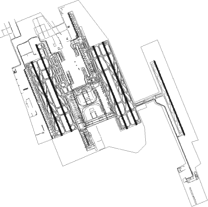
Taxiway locations
|
Parking locations
Nearby beacons
| code | identifier | dist | bearing | frequency |
|---|---|---|---|---|
| PUD | PUDONG VOR/DME | 1.6 | 339° | 116.90 |
| PDL | LIUZAO VOR/DME | 6.3 | 263° | 109.40 |
| XSY | SHUYUAN VOR/DME | 13.4 | 159° | 112.70 |
| HSH | HENGSHA VOR/DME | 13.6 | 13° | 114.40 |
| JTN | JIUTING VOR/DME | 23.2 | 267° | 109.60 |
| SHA | HONGQIAO VOR/DME | 24 | 280° | 117.20 |
| PK | NANXIANG NDB | 25.2 | 287° | 208 |
| CGT | CHONGGU VOR/DME | 31 | 276° | 112.50 |
| AND | ANDONG VOR/DME | 60.9 | 213° | 114.80 |
| W | XINGDONG (NANTONG) NDB | 68.3 | 318° | 425 |
| NTG | NANTONG VOR/DME | 70.7 | 320° | 115.60 |
Departure and arrival routes
| Transition altitude | 9800ft |
| Transition level | 11800ft |
| SID end points | distance | outbound heading | |
|---|---|---|---|
| RW16L | |||
| SUR12D, SUR82D | 95mi | 70° | |
| LAM84D, LAM82D, LAM12D | 117mi | 78° | |
| MIG12D, MIG82D | 101mi | 101° | |
| HSN12D, HSN82D | 79mi | 155° | |
| NXD84D, NXD82D, NXD12D | 72mi | 260° | |
| SAS84D, SAS82D, SAS12D | 80mi | 287° | |
| PIK86D, PIK84D, PIK82D, PIK14D, PIK12D | 82mi | 314° | |
| ODU12D, ODU14D, ODU82D, ODU84D | 127mi | 355° | |
| RW16R | |||
| SUR12D, SUR82D | 95mi | 70° | |
| LAM12D, LAM82D, LAM84D | 117mi | 78° | |
| MIG82D, MIG12D | 101mi | 101° | |
| HSN82D, HSN12D | 79mi | 155° | |
| NXD12D, NXD82D, NXD84D | 72mi | 260° | |
| SAS84D, SAS82D, SAS12D | 80mi | 287° | |
| PIK14D, PIK86D, PIK84D, PIK82D, PIK12D | 82mi | 314° | |
| ODU84D, ODU82D, ODU14D, ODU12D | 127mi | 355° | |
| RW17 (ALL) | |||
| NXD11D | 72mi | 260° | |
| SAS11D | 80mi | 287° | |
| PIK11D | 82mi | 314° | |
| RW17L | |||
| SUR11D, SUR81D | 95mi | 70° | |
| LAM81D, LAM11D | 117mi | 78° | |
| MIG11D, MIG81D | 101mi | 101° | |
| HSN11D, HSN81D | 79mi | 155° | |
| NXD81D | 72mi | 260° | |
| SAS81D | 80mi | 287° | |
| PIK83D, PIK13D, PIK81D | 82mi | 314° | |
| ODU83D, ODU81D, ODU13D, ODU11D | 127mi | 355° | |
| RW17R | |||
| SUR11D, SUR81D | 95mi | 70° | |
| LAM81D, LAM11D | 117mi | 78° | |
| MIG11D, MIG81D | 101mi | 101° | |
| HSN81D, HSN11D | 79mi | 155° | |
| NXD81D | 72mi | 260° | |
| SAS81D | 80mi | 287° | |
| PIK13D, PIK81D, PIK83D | 82mi | 314° | |
| ODU13D, ODU11D, ODU83D, ODU81D | 127mi | 355° | |
| RW34L | |||
| SUR02D, SUR04D, SUR92D, SUR94D | 95mi | 70° | |
| LAM96D, LAM94D, LAM92D, LAM02D, LAM04D | 117mi | 78° | |
| MIG92D, MIG02D | 101mi | 101° | |
| HSN92D, HSN02D | 79mi | 155° | |
| NXD02D, NXD94D, NXD92D | 72mi | 260° | |
| SAS94D, SAS92D, SAS02D | 80mi | 287° | |
| PIK98D, PIK96D, PIK94D, PIK92D, PIK04D, PIK02D | 82mi | 314° | |
| ODU02D, ODU04D, ODU92D, ODU94D | 127mi | 355° | |
| RW34R | |||
| SUR02D, SUR04D, SUR92D, SUR94D | 95mi | 70° | |
| LAM94D, LAM96D, LAM92D, LAM02D, LAM04D | 117mi | 78° | |
| MIG92D, MIG02D | 101mi | 101° | |
| HSN92D, HSN02D | 79mi | 155° | |
| NXD02D, NXD94D, NXD92D | 72mi | 260° | |
| SAS94D, SAS92D, SAS02D | 80mi | 287° | |
| PIK98D, PIK96D, PIK94D, PIK92D, PIK04D, PIK02D | 82mi | 314° | |
| ODU02D, ODU04D, ODU92D, ODU94D | 127mi | 355° | |
| RW35 (ALL) | |||
| HSN01D | 79mi | 155° | |
| PIK03D, PIK01D | 82mi | 314° | |
| ODU03D, ODU01D | 127mi | 355° | |
| RW35L | |||
| SUR01D, SUR03D, SUR91D, SUR93D, SUR95D | 95mi | 70° | |
| LAM95D, LAM91D, LAM01D, LAM03D, LAM93D | 117mi | 78° | |
| MIG01D, MIG91D | 101mi | 101° | |
| HSN91D | 79mi | 155° | |
| NXD91D, NXD01D | 72mi | 260° | |
| SAS91D, SAS01D | 80mi | 287° | |
| PIK95D, PIK93D, PIK91D | 82mi | 314° | |
| ODU91D, ODU93D | 127mi | 355° | |
| RW35R | |||
| SUR01D, SUR03D, SUR91D, SUR93D, SUR95D | 95mi | 70° | |
| LAM95D, LAM93D, LAM91D, LAM03D, LAM01D | 117mi | 78° | |
| MIG01D, MIG91D | 101mi | 101° | |
| HSN91D | 79mi | 155° | |
| NXD91D, NXD01D | 72mi | 260° | |
| SAS01D, SAS91D | 80mi | 287° | |
| PIK93D, PIK91D, PIK95D | 82mi | 314° | |
| ODU93D, ODU91D | 127mi | 355° | |
| STAR starting points | distance | inbound heading | |
|---|---|---|---|
| ALL | |||
| BK01A, BK11A | 78.6 | 20° | |
| SAS11A, SAS01A | 80.1 | 107° | |
| MAT01A | 53.0 | 238° | |
| DUM01A | 52.0 | 258° | |
| RW16 (ALL) | |||
| BK81A, BK82A, BK83A | 78.6 | 20° | |
| SAS82A, SAS81A | 80.1 | 107° | |
| MAT81A, MAT82A | 53.0 | 238° | |
| MAT11A | 38.3 | 245° | |
| DUM83A, DUM82A, DUM81A | 52.0 | 258° | |
| RW17 (ALL) | |||
| BK83A, BK82A, BK81A | 78.6 | 20° | |
| SAS82A, SAS81A | 80.1 | 107° | |
| MAT82A, MAT81A | 53.0 | 238° | |
| MAT11A | 38.3 | 245° | |
| DUM82A, DUM81A | 52.0 | 258° | |
| RW34 (ALL) | |||
| BK91A | 78.6 | 20° | |
| SAS93A, SAS92A, SAS91A | 80.1 | 107° | |
| MAT91A, MAT92A | 53.0 | 238° | |
| DUM93A, DUM92A, DUM91A | 52.0 | 258° | |
| RW35 (ALL) | |||
| BK91A | 78.6 | 20° | |
| SAS93A, SAS92A, SAS91A | 80.1 | 107° | |
| MAT92A, MAT91A | 53.0 | 238° | |
| DUM92A, DUM91A | 52.0 | 258° | |
Holding patterns
| STAR name | hold at | type | turn | heading* | altitude | leg | speed limit |
|---|---|---|---|---|---|---|---|
| AND01A | D202X | VHF | left | 242 (62)° | 1.0min timed | 225 | |
| AND11A | D202X | VHF | left | 242 (62)° | 1.0min timed | 225 | |
| AND11A | PDL | NDB | left | 168 (348)° | > 8860ft | 1.0min timed | 225 |
| AND11A | XSY | NDB | right | 202 (22)° | 1.0min timed | 225 | |
| AND12A | D202X | VHF | left | 242 (62)° | 1.0min timed | 225 | |
| AND12A | HSH | NDB | right | 168 (348)° | > 2960ft | 1.0min timed | 225 |
| AND12A | XSY | NDB | right | 202 (22)° | 1.0min timed | 225 | |
| AND81A | PD208 | VHF | left | 242 (62)° | 1.0min timed | 230 | |
| AND82A | PD208 | VHF | left | 242 (62)° | 1.0min timed | 230 | |
| AND83A | PD208 | VHF | left | 242 (62)° | 1.0min timed | 230 | |
| AND91A | PD208 | VHF | left | 242 (62)° | 1.0min timed | 230 | |
| BK01A | D202X | VHF | left | 242 (62)° | 1.0min timed | 225 | |
| BK11A | D202X | VHF | left | 242 (62)° | 1.0min timed | 225 | |
| BK11A | PDL | NDB | left | 168 (348)° | > 8860ft | 1.0min timed | 225 |
| BK11A | XSY | NDB | right | 202 (22)° | 1.0min timed | 225 | |
| BK12A | D202X | VHF | left | 242 (62)° | 1.0min timed | 225 | |
| BK12A | HSH | NDB | right | 168 (348)° | > 2960ft | 1.0min timed | 225 |
| BK12A | XSY | NDB | right | 202 (22)° | 1.0min timed | 225 | |
| BK81A | PD208 | VHF | left | 242 (62)° | 1.0min timed | 230 | |
| BK82A | PD208 | VHF | left | 242 (62)° | 1.0min timed | 230 | |
| BK83A | PD208 | VHF | left | 242 (62)° | 1.0min timed | 230 | |
| BK91A | PD208 | VHF | left | 242 (62)° | 1.0min timed | 230 | |
| DUM01A | PU31A | VHF | left | 82 (262)° | 7880ft - 16700ft | 1.5min timed | 225 |
| DUM11A | HSH | NDB | right | 168 (348)° | > 2960ft | 1.0min timed | 225 |
| MAT01A | PINOT | VHF | left | 86 (266)° | 1.0min timed | 225 | |
| MAT11A | HSH | NDB | right | 168 (348)° | > 2960ft | 1.0min timed | 225 |
| MAT11A | PINOT | VHF | left | 86 (266)° | 1.0min timed | 225 | |
| MAT81A | PINOT | VHF | left | 86 (266)° | 1.0min timed | 225 | |
| MAT82A | PINOT | VHF | left | 86 (266)° | 1.0min timed | 225 | |
| MAT91A | PINOT | VHF | left | 86 (266)° | 1.0min timed | 225 | |
| MAT92A | PINOT | VHF | left | 86 (266)° | 1.0min timed | 225 | |
| SAS01A | JTN | NDB | left | 274 (94)° | 1.0min timed | 225 | |
| SAS01A | PDL | NDB | left | 168 (348)° | > 8860ft | 1.0min timed | 225 |
| SAS11A | TOSAS | VHF | right | 265 (85)° | 5910ft - 7880ft | 1.0min timed | 225 |
| *) magnetic outbound (inbound) holding course | |||||||
Disclaimer
The information on this website is not for real aviation. Use this data with the X-Plane flight simulator only! Data taken with kind consent from X-Plane 12 source code and data files. Content is subject to change without notice.