Shanghai - Shanghai Hongqiao Intl
Airport details
| Country | China |
| State | Shanghai Municipality |
| Region | ZS |
| Airspace | Shanghai Ctr |
| Municipality | Shanghai |
| Elevation | 7ft (2m) |
| Timezone | GMT +8 |
| Coordinates | 31.21056, 121.33883 |
| Magnetic var | |
| Type | land |
| Available since | X-Plane v10.40 |
| ICAO code | ZSSS |
| IATA code | SHA |
| FAA code | n/a |
Communication
| Shanghai Hongqiao Intl ATIS | 132.250 |
| Shanghai Hongqiao Intl Hongqiao Delivery | 121.750 |
| Shanghai Hongqiao Intl Hongqiao Ground (West) | 121.900 |
| Shanghai Hongqiao Intl Hongqiao Apron (East) | 121.675 |
| Shanghai Hongqiao Intl Hongqiao Apron (West) | 121.950 |
| Shanghai Hongqiao Intl Hongqiao Ground (East) | 121.600 |
| Shanghai Hongqiao Intl Shanghai Approach 11 | 119.075 |
| Shanghai Hongqiao Intl Hongqiao Tower (East) | 118.100 |
| Shanghai Hongqiao Intl Hongqiao Tower (West) | 118.650 |
| Shanghai Hongqiao Intl Shanghai Approach 03 | 125.850 |
| Shanghai Hongqiao Intl Shanghai Approach 07 | 121.100 |
| Shanghai Hongqiao Intl Shanghai Approach 04 | 123.800 |
| Shanghai Hongqiao Intl Shanghai Approach 08 | 127.750 |
| Shanghai Hongqiao Intl Shanghai Approach 01 | 120.300 |
| Shanghai Hongqiao Intl Shanghai Approach 05 | 126.650 |
| Shanghai Hongqiao Intl Shanghai Approach 09 | 121.375 |
| Shanghai Hongqiao Intl Shanghai Approach 02 | 125.400 |
| Shanghai Hongqiao Intl Shanghai Approach 06 | 126.300 |
| Shanghai Hongqiao Intl Shanghai Approach 10 | 125.625 |
Approach frequencies
| ILS-cat-I | RW18R | 110.9 | 18.00mi |
| ILS-cat-I | RW18L | 111.3 | 18.00mi |
| ILS-cat-I | RW36L | 111.7 | 18.00mi |
| ILS-cat-I | RW36R | 110.3 | 18.00mi |
| 3° GS | RW18R | 110.9 | 18.00mi |
| 3° GS | RW18L | 111.3 | 18.00mi |
| 3° GS | RW36L | 111.7 | 18.00mi |
| 3° GS | RW36R | 110.3 | 18.00mi |
Nearby Points of Interest:
grave of Soong Ching-ling
-Main Hall of Zhenru Temple
-Zhongshan Hospital
-Shanghai Changning Children's Palace
-Wukang Mansion
-Soong Ching-ling Memorial Residence (Shanghai)
-Bibliotheca Zi-Ka-Wei
-Huadong Hospital
-Our Lady Cathedral, Shanghai
-Moller Villa
-Saint Nicholas' Church, Shanghai
-Former Residence of Zhou Enlai in Shanghai
-Great World, Shanghai
-General Post Office Building, Shanghai
-Shanghai Navy YMCA
-Shanghai Club Building
-Brookside Apartments
-Yongnian Mansion
-The Bank of China, Hongkew Branch
-Headquarter Buildings of Y.W.C.A
-Gutzlaff Signal Tower
-Bank of Taiwan Building
Runway info
Runway 18L / 36R  | ||
| length | 3403m (11165ft) | |
| bearing | 177° / 357° | |
| width | 45m (148ft) | |
| surface | asphalt | |
| displ threshold | 100m (328ft) / 100m (328ft) | |
| blast zone | 60m (197ft) / 60m (197ft) | |
| Runway 18R / 36L | ||
| length | 3303m (10837ft) | |
| bearing | 177° / 357° | |
| width | 60m (197ft) | |
| surface | concrete | |
| displ threshold | 300m (984ft) / 300m (984ft) | |
| blast zone | 120m (394ft) / 120m (394ft) | |
Airport layout
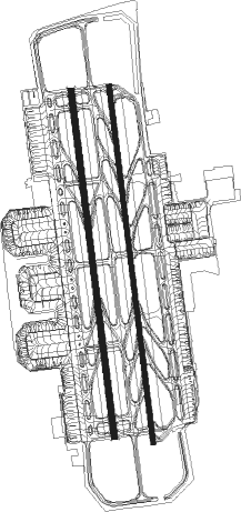
Taxiway locations
Parking locations
|
Nearby beacons
| code | identifier | dist | bearing | frequency |
|---|---|---|---|---|
| SHA | HONGQIAO VOR/DME | 0.7 | 341° | 117.20 |
| PK | NANXIANG NDB | 4.3 | 353° | 208 |
| JTN | JIUTING VOR/DME | 5.2 | 178° | 109.60 |
| CGT | CHONGGU VOR/DME | 7.4 | 270° | 112.50 |
| PDL | LIUZAO VOR/DME | 17.7 | 104° | 109.40 |
| PUD | PUDONG VOR/DME | 22.9 | 95° | 116.90 |
| HSH | HENGSHA VOR/DME | 27.7 | 73° | 114.40 |
| XSY | SHUYUAN VOR/DME | 32.1 | 118° | 112.70 |
| SUF | SHUOFANG VOR/DME | 49.6 | 288° | 114.10 |
| NXD | NANXUN VOR/DME | 50.4 | 251° | 116.50 |
| W | XINGDONG (NANTONG) NDB | 53.5 | 337° | 425 |
| NTG | NANTONG VOR/DME | 56.3 | 338° | 115.60 |
| AND | ANDONG VOR/DME | 57.6 | 187° | 114.80 |
| HGH | HANGZHOU VOR/DME | 73.8 | 222° | 113 |
Departure and arrival routes
| Transition altitude | 9842ft |
| Transition level | 11811ft |
| SID end points | distance | outbound heading | |
|---|---|---|---|
| RW18 (ALL) | |||
| IBE31D | 60mi | 57° | |
| SUR31D | 115mi | 75° | |
| LAM31D | 138mi | 81° | |
| MIG31D | 124mi | 101° | |
| PON31D | 66mi | 120° | |
| NXD31D | 50mi | 251° | |
| SAS31D | 57mi | 290° | |
| PIK31D | 65mi | 328° | |
| RW18L | |||
| IBE61D | 60mi | 57° | |
| SUR61D | 115mi | 75° | |
| LAM61D | 138mi | 81° | |
| MIG61D | 124mi | 101° | |
| PON61D | 66mi | 120° | |
| NXD61D | 50mi | 251° | |
| SAS61D | 57mi | 290° | |
| PIK61D | 65mi | 328° | |
| RW18R | |||
| IBE61D | 60mi | 57° | |
| SUR61D | 115mi | 75° | |
| LAM61D | 138mi | 81° | |
| MIG61D | 124mi | 101° | |
| PON61D | 66mi | 120° | |
| NXD61D | 50mi | 251° | |
| SAS61D | 57mi | 290° | |
| PIK61D | 65mi | 328° | |
| RW36 (ALL) | |||
| IBE21D | 60mi | 57° | |
| SUR21D | 115mi | 75° | |
| LAM21D | 138mi | 81° | |
| MIG21D | 124mi | 101° | |
| PON21D | 66mi | 120° | |
| NXD21D | 50mi | 251° | |
| SAS21D | 57mi | 290° | |
| PIK21D | 65mi | 328° | |
| RW36L | |||
| IBE73D, IBE71D | 60mi | 57° | |
| SUR73D, SUR71D | 115mi | 75° | |
| LAM71D, LAM73D | 138mi | 81° | |
| MIG71D | 124mi | 101° | |
| PON71D | 66mi | 120° | |
| NXD71D | 50mi | 251° | |
| SAS71D, SAS72D | 57mi | 290° | |
| PIK72D, PIK71D | 65mi | 328° | |
| RW36R | |||
| IBE71D, IBE73D | 60mi | 57° | |
| SUR71D, SUR73D | 115mi | 75° | |
| LAM73D, LAM71D | 138mi | 81° | |
| MIG71D | 124mi | 101° | |
| PON71D | 66mi | 120° | |
| NXD71D | 50mi | 251° | |
| SAS71D, SAS72D | 57mi | 290° | |
| PIK71D, PIK72D | 65mi | 328° | |
| STAR starting points | distance | inbound heading | |
|---|---|---|---|
| RW18 (ALL) | |||
| SUP31A, SUP61A | 75.5 | 22° | |
| SAS31A, SAS61A, SAS62A | 56.9 | 110° | |
| PUD31A, PUD61A | 22.9 | 275° | |
| RW36 (ALL) | |||
| SUP71A, SUP21A | 75.5 | 22° | |
| SAS71A, SAS21A | 56.9 | 110° | |
| PUD72A, PUD71A, PUD21A | 22.9 | 275° | |
Holding patterns
| STAR name | hold at | type | turn | heading* | altitude | leg | speed limit |
|---|---|---|---|---|---|---|---|
| AND21A | AND28 | VHF | right | 192 (12)° | 9850ft - 16700ft | 1.5min timed | 225 |
| AND31A | AND28 | VHF | right | 192 (12)° | 9850ft - 16700ft | 1.5min timed | 225 |
| AND31A | CGT | NDB | right | 183 (3)° | > 5910ft | 1.0min timed | 225 |
| AND32A | CGT | NDB | right | 183 (3)° | > 5910ft | 1.0min timed | 225 |
| AND61A | SS207 | VHF | right | 192 (12)° | 9850ft - 16700ft | 1.5min timed | 230 |
| AND71A | SS207 | VHF | right | 192 (12)° | 9850ft - 16700ft | 1.5min timed | 230 |
| PUD21A | CGT | NDB | right | 183 (3)° | > 5910ft | 1.0min timed | 225 |
| PUD31A | CGT | NDB | right | 183 (3)° | > 5910ft | 1.0min timed | 225 |
| SAS21A | CGT | NDB | right | 183 (3)° | > 5910ft | 1.0min timed | 225 |
| SUP31A | CGT | NDB | right | 183 (3)° | > 5910ft | 1.0min timed | 225 |
| *) magnetic outbound (inbound) holding course | |||||||
Disclaimer
The information on this website is not for real aviation. Use this data with the X-Plane flight simulator only! Data taken with kind consent from X-Plane 12 source code and data files. Content is subject to change without notice.