Accra - Kotoka Intl
Airport details
| Country | Ghana |
| State | Greater Accra Region |
| Region | DG |
| Airspace | Accra Ctr |
| Municipality | Accra |
| Elevation | 204ft (62m) |
| Timezone | GMT +0 |
| Coordinates | 5.60169, -0.16254 |
| Magnetic var | |
| Type | land |
| Available since | X-Plane v10.40 |
| ICAO code | DGAA |
| IATA code | ACC |
| FAA code | n/a |
Communication
| Kotoka Intl ATIS | 113.100 |
| Kotoka Intl Ground Control | 121.900 |
| Kotoka Intl Tower | 118.600 |
| Kotoka Intl Approach | 119.100 |
| Kotoka Intl Approach | 119.500 |
| Kotoka Intl Departure | 119.100 |
Approach frequencies
| ILS-cat-I | RW21 | 109.9 | 18.00mi |
| 3° GS | RW21 | 109.9 | 18.00mi |
Nearby Points of Interest:
Fort Augustaborg
-Ussher Fort
-Sakumono Lagoon
-Densu River
-Fort Fredensborg
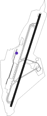
Runway info
| Runway 03 / 21 | ||
| length | 3406m (11175ft) | |
| bearing | 22° / 202° | |
| width | 61m (200ft) | |
| surface | asphalt | |
| displ threshold | 0m (0ft) / 408m (1339ft) | |
| blast zone | 119m (390ft) / 61m (200ft) | |
Nearby beacons
| code | identifier | dist | bearing | frequency |
|---|---|---|---|---|
| ACC | ACCRA VOR/DME | 1.9 | 12° | 113.10 |
| AL | ACCRA NDB | 2.2 | 211° | 258 |
Departure and arrival routes
| Transition altitude | 3000ft |
| Transition level | 4000ft |
| SID end points | distance | outbound heading | |
|---|---|---|---|
| RW03 | |||
| EREK1C | 61mi | 68° | |
| MIMT1C | 59mi | 266° | |
| KEMO1C | 61mi | 308° | |
| RW21 | |||
| LITE1D | 62mi | 3° | |
| EREK1D | 61mi | 68° | |
| DIRK1D | 59mi | 247° | |
| MIMT1D | 59mi | 266° | |
| KEMO1D | 61mi | 308° | |
| STAR starting points | distance | inbound heading | |
|---|---|---|---|
| RW03 | |||
| MIMT1A | 59.3 | 86° | |
| KEMO1A | 60.8 | 128° | |
| EREK1A | 61.1 | 248° | |
| RW21 | |||
| DIRK1B | 58.8 | 67° | |
| MIMT1B | 59.3 | 86° | |
| KEMO1B | 60.8 | 128° | |
| LITE1B | 62.2 | 183° | |
| EREK1B | 61.1 | 248° | |
Instrument approach procedures
| runway | airway (heading) | route (dist, bearing) |
|---|---|---|
| RW03 | NARAT (49°) | NARAT 3500ft ANOGA (5mi, 112°) 1900ft |
| RW03 | NARVO (359°) | NARVO 3500ft ANOGA (5mi, 292°) 1900ft |
| RNAV | ANOGA 1900ft AA400 (5mi, 22°) 1900ft DGAA (6mi, 26°) 227ft (337mi, 178°) 1100ft NARVO (325mi, 358°) 3500ft NARVO (turn) 3500ft | |
| RW21 | AKMUS (201°) | AKMUS 3900ft KEDOS (5mi, 202°) 2300ft |
| RW21 | MISPA (176°) | MISPA 3900ft KEDOS (5mi, 112°) 2300ft |
| RW21 | RASET (226°) | RASET 3900ft KEDOS (5mi, 292°) 2300ft |
| RNAV | KEDOS 2300ft AA500 (5mi, 202°) 1900ft DGAA (6mi, 199°) 247ft (337mi, 178°) 1100ft RASET (345mi, 360°) 3900ft RASET (turn) 3900ft |
Holding patterns
| STAR name | hold at | type | turn | heading* | altitude | leg | speed limit |
|---|---|---|---|---|---|---|---|
| DIRK1B | APATI | VHF | left | 268 (88)° | > 12000ft | 1.0min timed | ICAO rules |
| EREK1A | APERI | VHF | left | 69 (249)° | > 16000ft | 1.0min timed | ICAO rules |
| EREK1B | AGSAR | VHF | right | 85 (265)° | > 9000ft | 1.0min timed | ICAO rules |
| KEMO1A | SENAN | VHF | right | 314 (134)° | > 15000ft | 1.0min timed | ICAO rules |
| KEMO1B | DISNO | VHF | left | 308 (128)° | > 11000ft | 1.0min timed | ICAO rules |
| LITE1B | EDLAB | VHF | right | 358 (178)° | > 9000ft | 1.0min timed | ICAO rules |
| MIMT1A | RAVEX | VHF | right | 279 (99)° | > 10000ft | 1.0min timed | ICAO rules |
| MIMT1B | APATI | VHF | left | 268 (88)° | > 12000ft | 1.0min timed | ICAO rules |
| *) magnetic outbound (inbound) holding course | |||||||
Disclaimer
The information on this website is not for real aviation. Use this data with the X-Plane flight simulator only! Data taken with kind consent from X-Plane 12 source code and data files. Content is subject to change without notice.