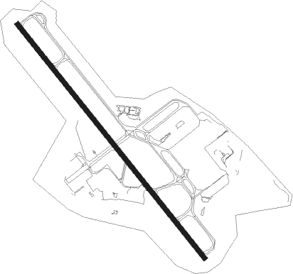
Birmingham
Airport details
| Country | United Kingdom |
| State | England |
| Region | EG |
| Airspace | London Ctr |
| Municipality | Metropolitan Borough of Solihull |
| Elevation | 327ft (100m) |
| Timezone | GMT +0 |
| Coordinates | 52.45386, -1.74803 |
| Magnetic var | |
| Type | land |
| Available since | X-Plane v10.40 |
| ICAO code | EGBB |
| IATA code | BHX |
| FAA code | n/a |
Communication
| Birmingham Birmingham Information | 136.030 |
| Birmingham Birmingham Delivery | 121.930 |
| Birmingham Birmingham Ground | 121.805 |
| Birmingham Birmginham Tower | 118.305 |
| Birmingham Birmingham Approach | 131.005 |
Approach frequencies
| ILS-cat-III | RW15 | 110.1 | 18.00mi |
| ILS-cat-III | RW33 | 110.1 | 18.00mi |
| 3° GS | RW15 | 110.1 | 18.00mi |
| 3° GS | RW33 | 110.1 | 18.00mi |
Nearby Points of Interest:
Packington Hall
-Packington Old Hall
-Hay Hall
-Castle Bromwich Hall
-Blyth Hall
-Church of St Oswald
-Emmanuel Church
-Berkswell Hall
-Pype Hayes Hall
-Stratford House
-Friends' Institute buildings
-Moseley School of Art, Balsall Heath
-Curzon Street railway station
-Moseley Hall, Birmingham
-Christopher Wray Lighting works
-Fox And Grapes
-Methodist Central Hall, Birmingham
-Victoria Law Courts
-Birmingham Children's Hospital
-Great Western Arcade
-Singers Hill Synagogue
-103 Colmore Row
-17 & 19 Newhall Street, Birmingham
-Council House, Birmingham
-Queen's College
Nearby beacons
| code | identifier | dist | bearing | frequency |
|---|---|---|---|---|
| BHX | BIRMINGHAM NDB | 0.1 | 279° | 406 |
| HON | HONILEY VOR/DME | 6.6 | 139° | 113.65 |
| WBA | WOLVERHAMPTON NDB | 19.1 | 277° | 356 |
| WOL | DME | 19.1 | 277° | 108.60 |
| TNL | TATENHILL NDB | 21.6 | 357° | 327 |
| EMW | EAST MIDLANDS NDB | 24.9 | 38° | 393 |
| LE | LEICESTER NDB | 27.6 | 78° | 383 |
| DTY | DAVENTRY VOR/DME | 28.5 | 113° | 116.40 |
| EME | EAST MIDLANDS NDB | 30.4 | 56° | 353 |
| TNT | TRENT VOR/DME | 36.1 | 7° | 115.70 |
| GST | GLOUCESTERSHIRE NDB | 37.1 | 217° | 331 |
| SWB | SHAWBURY VOR/DME | 39.2 | 291° | 116.80 |
| OX | OXFORD NDB | 40.4 | 146° | 367 |
| BZ | BRIZE NORTON NDB | 42.6 | 168° | 386 |
| BZN | BRIZE NORTON TACAN | 42.7 | 168° | 111.90 |
| WCO | WESTCOTT NDB | 46.2 | 127° | 335 |
| FFA | FAIRFORD TACAN | 46.4 | 184° | 113.40 |
| WHI | WHITEGATE NDB | 54.1 | 310° | 368 |
| HEN | HENTON NDB | 54.6 | 126° | 433 |
| BSO | BENSON TACAN | 55.8 | 142° | 110 |
| MCT | MANCHESTER VOR/DME | 57.3 | 330° | 113.55 |
| GAM | GAMSTON VOR/DME | 57.5 | 44° | 112.80 |
| CPT | COMPTON VOR/DME | 61 | 151° | 114.35 |
| LPL | LIVERPOOL NDB | 63.8 | 312° | 349 |
| OF | FILTON NDB | 64.1 | 222° | 325 |
Departure and arrival routes
| Transition altitude | 6000ft |
| SID end points | distance | outbound heading | |
|---|---|---|---|
| RW15 | |||
| LUVU1L | 16mi | 0° | |
| TNT4G, TNT1K | 36mi | 7° | |
| DTY2Y | 29mi | 113° | |
| WCO2Y | 46mi | 127° | |
| COWL2Y | 56mi | 141° | |
| CPT2Y | 61mi | 151° | |
| LUXT15 | 22mi | 225° | |
| MOSU15 | 42mi | 231° | |
| RW33 | |||
| LUVU1M | 16mi | 0° | |
| UNGA1M | 14mi | 105° | |
| ADME1M | 12mi | 108° | |
| DTY4F | 29mi | 113° | |
| UMLU1M | 10mi | 253° | |
| STAR starting points | distance | inbound heading | |
|---|---|---|---|
| ALL | |||
| FIGZ1B | 43.2 | 60° | |
| DOLO1B | 82.1 | 112° | |
| MAKU2B | 144.8 | 116° | |
| AMPI1B | 68.7 | 117° | |
| MALU1B | 88.6 | 117° | |
| WAL1B | 75.4 | 124° | |
| CHAS4B | 76.0 | 146° | |
| CHAS3G | 78.5 | 165° | |
| CHAS3F | 103.1 | 168° | |
| CHAS3H | 64.6 | 172° | |
| HEME1B | 62.5 | 296° | |
| SILV1B | 45.5 | 309° | |
Holding patterns
| STAR name | hold at | type | turn | heading* | altitude | leg | speed limit |
|---|---|---|---|---|---|---|---|
| AMPI1B | CHASE | VHF | right | 329 (149)° | 5000ft - 14000ft | 1.0min timed | 210 |
| CHAS3F | CHASE | VHF | right | 329 (149)° | 5000ft - 14000ft | 1.0min timed | 210 |
| CHAS3G | CHASE | VHF | right | 329 (149)° | 5000ft - 14000ft | 1.0min timed | 210 |
| CHAS3H | CHASE | VHF | right | 329 (149)° | 5000ft - 14000ft | 1.0min timed | 210 |
| CHAS4B | CHASE | VHF | right | 329 (149)° | 5000ft - 14000ft | 1.0min timed | 210 |
| DOLO1B | CHASE | VHF | right | 329 (149)° | 5000ft - 14000ft | 1.0min timed | 210 |
| FIGZ1B | GROVE | VHF | right | 283 (103)° | 7000ft - 14000ft | 1.0min timed | 210 |
| HEME1B | GROVE | VHF | right | 283 (103)° | 7000ft - 14000ft | 1.0min timed | 210 |
| MAKU2B | CHASE | VHF | right | 329 (149)° | 5000ft - 14000ft | 1.0min timed | 210 |
| MALU1B | CHASE | VHF | right | 329 (149)° | 5000ft - 14000ft | 1.0min timed | 210 |
| SILV1B | GROVE | VHF | right | 283 (103)° | 7000ft - 14000ft | 1.0min timed | 210 |
| WAL1B | CHASE | VHF | right | 329 (149)° | 5000ft - 14000ft | 1.0min timed | 210 |
| *) magnetic outbound (inbound) holding course | |||||||
Disclaimer
The information on this website is not for real aviation. Use this data with the X-Plane flight simulator only! Data taken with kind consent from X-Plane 12 source code and data files. Content is subject to change without notice.