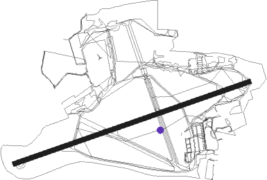
Bournemouth
Airport details
| Country | United Kingdom |
| State | England |
| Region | EG |
| Airspace | London Ctr |
| Municipality | Hurn |
| Elevation | 38ft (12m) |
| Timezone | GMT +0 |
| Coordinates | 50.78000, -1.84250 |
| Magnetic var | |
| Type | land |
| Available since | X-Plane v10.40 |
| ICAO code | EGHH |
| IATA code | BOH |
| FAA code | n/a |
Communication
| Bournemouth Bournemouth Information | 133.725 |
| Bournemouth Bournemouth Ground | 121.700 |
| Bournemouth Bournemouth Radar | 119.475 |
| Bournemouth Bournemouth Tower | 125.600 |
| Bournemouth Bournemouth Approach | 119.475 |
Approach frequencies
| ILS-cat-III | RW26 | 110.5 | 18.00mi |
| ILS-cat-I | RW08 | 110.5 | 18.00mi |
| 3° GS | RW26 | 110.5 | 18.00mi |
| 3° GS | RW08 | 110.5 | 18.00mi |
Nearby Points of Interest:
Dudsbury Camp
-O2 Academy Bournemouth
-Stapehill Abbey
-The Town Hall
-Sacred Heart Church, Bournemouth
-Bournemouth War Memorial
-Holt Heath
-Christchurch Harbour
-Warren Hill
-Hinton Admiral
-Priest's House Museum
-Somerley
-Poole Civic Centre
-St Ann's Hospital, Dorset
-Crichel House
-St Giles House, Wimborne St Giles
-Cranborne Manor
-St Aldhelm's Chapel
-Arne RSPB reserve
-Boulsbury Wood
-St Mary's Church, Long Crichel
-Charborough House
-Swanage Pier
-The Clock Tower
Runway info
| Runway 08 / 26 | ||
| length | 2267m (7438ft) | |
| bearing | 81° / 261° | |
| width | 46m (151ft) | |
| surface | asphalt | |
| displ threshold | 434m (1424ft) / 0m (0ft) | |
| blast zone | 0m (0ft) / 48m (157ft) | |
Nearby beacons
| code | identifier | dist | bearing | frequency |
|---|---|---|---|---|
| BIA | BOURNEMOUTH NDB | 0.1 | 180° | 339 |
| EAS | SOUTHAMPTON (EASTLEIGH) NDB | 21.2 | 70° | 391 |
| SAM | SOUTHAMPTON VOR/DME | 21.5 | 71° | 113.35 |
| BDN | BOSCOMBE DOWN TACAN | 22.4 | 14° | 108.20 |
| YVL | DME | 32.2 | 281° | 109.05 |
| YVL | YEOVIL NDB | 32.6 | 281° | 343 |
| VLN | YEOVILTON TACAN | 33 | 286° | 111 |
| ODH | ODIHAM TACAN | 43.3 | 63° | 109.60 |
| CPT | COMPTON VOR/DME | 48.7 | 41° | 114.35 |
| BRI | BRISTOL NDB | 48.9 | 305° | 414 |
| BLC | DME | 49.8 | 61° | 116.20 |
| BLK | BLACKBUSHE NDB | 49.8 | 61° | 328 |
| OF | FILTON NDB | 52.6 | 315° | 325 |
| FFA | FAIRFORD TACAN | 54.1 | 3° | 113.40 |
| WOD | WOODLEY NDB | 54.3 | 55° | 352 |
| BSO | BENSON TACAN | 57.4 | 42° | 110 |
| BZN | BRIZE NORTON TACAN | 58.8 | 14° | 111.90 |
| BZ | BRIZE NORTON NDB | 58.9 | 14° | 386 |
Departure and arrival routes
| Transition altitude | 6000ft |
| SID end points | distance | outbound heading | |
|---|---|---|---|
| RW08 | |||
| NORTH | 50mi | 46° | |
| EAST | 41mi | 86° | |
| SOUTH | 49mi | 198° | |
| RW26 | |||
| NORTH | 50mi | 46° | |
| EAST | 41mi | 86° | |
| SOUTH | 49mi | 198° | |
| STAR starting points | distance | inbound heading | |
|---|---|---|---|
| ALL | |||
| BUGU1S | 66.4 | 192° | |
| CPT1S | 48.7 | 221° | |
| COWL1S | 58.1 | 223° | |
| UMBU2S | 84.4 | 251° | |
| ELDA1S | 96.8 | 277° | |
| THRE1S | 18.2 | 328° | |
Holding patterns
| STAR name | hold at | type | turn | heading* | altitude | leg | speed limit |
|---|---|---|---|---|---|---|---|
| BUGU1S | PEPIS | VHF | right | 184 (4)° | 7000ft - 10000ft | 1.0min timed | 210 |
| BUGU1S | SAM | NDB | right | 210 (30)° | 2000ft - 10000ft | 1.0min timed | 210 |
| COWL1S | PEPIS | VHF | right | 184 (4)° | 7000ft - 10000ft | 1.0min timed | 210 |
| COWL1S | SAM | NDB | right | 210 (30)° | 2000ft - 10000ft | 1.0min timed | 210 |
| CPT1S | PEPIS | VHF | right | 184 (4)° | 7000ft - 10000ft | 1.0min timed | 210 |
| CPT1S | SAM | NDB | right | 210 (30)° | 2000ft - 10000ft | 1.0min timed | 210 |
| ELDA1S | RUDMO | VHF | left | 96 (276)° | 8000ft - 11000ft | 1.0min timed | 210 |
| ELDA1S | SAM | NDB | right | 210 (30)° | 2000ft - 10000ft | 1.0min timed | 210 |
| THRE1S | NEDUL | VHF | right | 205 (25)° | 4000ft - 15000ft | DME 5.0mi | 210 |
| UMBU2S | PEPIS | VHF | right | 184 (4)° | 7000ft - 10000ft | 1.0min timed | 210 |
| UMBU2S | SAM | NDB | right | 210 (30)° | 2000ft - 10000ft | 1.0min timed | 210 |
| *) magnetic outbound (inbound) holding course | |||||||
Disclaimer
The information on this website is not for real aviation. Use this data with the X-Plane flight simulator only! Data taken with kind consent from X-Plane 12 source code and data files. Content is subject to change without notice.
