London - London Heathrow
Airport details
| Country | United Kingdom |
| State | England |
| Region | EG |
| Airspace | London Ctr |
| Municipality | London |
| Elevation | 83ft (25m) |
| Timezone | GMT +0 |
| Coordinates | 51.46229, -0.45141 |
| Magnetic var | |
| Type | land |
| Available since | X-Plane v10.32 |
| ICAO code | EGLL |
| IATA code | LHR |
| FAA code | n/a |
Communication
| London Heathrow Heathrow ATIS | 128.080 |
| London Heathrow Heathrow Delivery | 121.980 |
| London Heathrow Heathrow Ground 3 | 121.855 |
| London Heathrow Heathrow Ground 1 | 121.905 |
| London Heathrow Heathrow Ground 2 | 121.705 |
| London Heathrow Heathrow Tower 1 | 118.505 |
| London Heathrow Heathrow Tower 2 | 118.705 |
| London Heathrow Heathrow Tower 3 | 124.475 |
| London Heathrow Heathrow Director 1 | 119.730 |
| London Heathrow Heathrow Director 2 | 134.980 |
| London Heathrow Heathrow Director 3 | 127.525 |
| London Heathrow Heathrow Director 4 | 120.400 |
| London Heathrow Heathrow Control 1 | 118.825 |
| London Heathrow Heathrow Control 5 | 133.180 |
| London Heathrow Heathrow Control 2 | 120.530 |
| London Heathrow Heathrow Control 3 | 134.125 |
| London Heathrow Heathrow Control 4 | 119.780 |
Approach frequencies
| ILS-cat-III | RW09L | 110.3 | 18.00mi |
| ILS-cat-III | RW09R | 109.5 | 18.00mi |
| ILS-cat-III | RW27L | 109.5 | 18.00mi |
| ILS-cat-III | RW27R | 110.3 | 18.00mi |
| 3° GS | RW09L | 110.3 | 18.00mi |
| 3° GS | RW09R | 109.5 | 18.00mi |
| 3° GS | RW27L | 109.5 | 18.00mi |
| 3° GS | RW27R | 110.3 | 18.00mi |
Nearby Points of Interest:
Longford Meeting House
-Wraysbury and Hythe End Gravel Pits
-Kneller Hall
-The Angel
-Windmill Bridge
-London International College
-Iver Grove
-The Cottage
-Chertsey Abbey
-Garrick's Temple to Shakespeare
-Garrick's Villa
-Chapel in the Wood
-Strawberry Hill House
-Town Hall
-Twickenham War Memorial
-Rose and Crown
-Beaumont College
-York House
-Hillingdon House
-isleworth
-Hillingdon Court
-Founder's Building
-Bushy House
-Wharncliffe Viaduct
-Hillingdon Civic Centre
Runway info
Runway 09L / 27R  | ||
| length | 3892m (12769ft) | |
| bearing | 90° / 270° | |
| width | 50m (164ft) | |
| surface | asphalt | |
| displ threshold | 306m (1004ft) / 0m (0ft) | |
| blast zone | 0m (0ft) / 55m (180ft) | |
| Runway 09R / 27L | ||
| length | 3651m (11978ft) | |
| bearing | 90° / 270° | |
| width | 50m (164ft) | |
| surface | asphalt | |
| displ threshold | 306m (1004ft) / 0m (0ft) | |
| blast zone | 0m (0ft) / 28m (92ft) | |
Airport layout
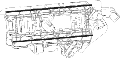
Taxiway locations
|
Parking locations
Nearby beacons
| code | identifier | dist | bearing | frequency |
|---|---|---|---|---|
| LON | LONDON VOR/DME | 1.6 | 329° | 113.60 |
| EPM | EPSOM NDB | 9 | 151° | 316 |
| BUR | BURNHAM NDB | 9.1 | 284° | 421 |
| OCK | OCKHAM VOR/DME | 9.4 | 178° | 115.30 |
| CHT | CHILTERN NDB | 9.9 | 337° | 277 |
| WOD | WOODLEY NDB | 16 | 269° | 352 |
| BNN | BOVINGDON VOR/DME | 16.2 | 340° | 113.75 |
| BLC | DME | 16.9 | 251° | 116.20 |
| BLK | BLACKBUSHE NDB | 16.9 | 251° | 328 |
| LCY | LONDON CITY NDB | 19.5 | 85° | 322 |
| BIG | BIGGIN VOR/DME | 19.8 | 105° | 115.10 |
| BPK | BROOKMANS PARK VOR/DME | 21.5 | 50° | 117.50 |
| HEN | HENTON NDB | 21.8 | 311° | 433 |
| ODH | ODIHAM TACAN | 23.1 | 245° | 109.60 |
| LAM | LAMBOURNE VOR/DME | 25 | 73° | 115.60 |
| MID | MIDHURST VOR/DME | 25.3 | 203° | 114 |
| BSO | BENSON TACAN | 25.8 | 283° | 110 |
| LUT | LUTON NDB | 27 | 25° | 345 |
| CPT | COMPTON VOR/DME | 28.7 | 272° | 114.35 |
| WCO | WESTCOTT NDB | 30.2 | 307° | 335 |
| MAY | MAYFIELD VOR/DME | 34.2 | 128° | 117.90 |
| BKY | BARKWAY VOR/DME | 36.9 | 44° | 116.25 |
| SHM | SHOREHAM NDB | 38 | 166° | 332 |
| SRH | DME-ILS | 38 | 166° | 109.95 |
| GWC | GOODWOOD VOR/DME | 38.2 | 207° | 114.75 |
| OX | OXFORD NDB | 39.4 | 293° | 367 |
| CIT | CRANFIELD NDB | 40.3 | 351° | 850 |
| DET | DETLING VOR/DME | 40.4 | 99° | 117.30 |
| SND | SOUTHEND NDB | 43.5 | 84° | 362 |
| HLS | DME | 45.3 | 106° | 115.95 |
| LSH | HEADCORN (LASHENDEN) NDB | 45.3 | 106° | 340 |
| SAM | SOUTHAMPTON VOR/DME | 45.3 | 240° | 113.35 |
| EAS | SOUTHAMPTON (EASTLEIGH) NDB | 45.6 | 241° | 391 |
| SFD | SEAFORD VOR/DME | 47.3 | 141° | 117 |
| DTY | DAVENTRY VOR/DME | 49.6 | 317° | 116.40 |
| CAM | CAMBRIDGE NDB | 50.7 | 40° | 332 |
| LYD | LYDD VOR/DME | 57.2 | 109° | 114.05 |
| LZD | LYDD NDB | 60.4 | 110° | 397 |
| CLN | CLACTON VOR/DME | 63.9 | 76° | 114.55 |
| MLD | MILDENHALL TACAN | 64.3 | 46° | 115.90 |
| WTZ | WATTISHAM TACAN | 65.1 | 65° | 109.30 |
| LKH | LAKENHEATH TACAN | 67.7 | 47° | 110.20 |
| DVR | DOVER VOR/DME | 70.3 | 99° | 114.95 |
Departure and arrival routes
| Transition altitude | 6000ft |
| Transition level | 70ft |
| SID end points | distance | outbound heading | |
|---|---|---|---|
| RW09L | |||
| ULTI1K | 14mi | 41° | |
| DET1K | 40mi | 99° | |
| MAY2K | 34mi | 128° | |
| MODM1K | 14mi | 189° | |
| GASG2K | 24mi | 243° | |
| CPT4K | 29mi | 272° | |
| RW09R | |||
| ULTI1J | 14mi | 41° | |
| DET1J | 40mi | 99° | |
| MAY2J | 34mi | 128° | |
| MODM1J | 14mi | 189° | |
| GASG2J | 24mi | 243° | |
| CPT5J | 29mi | 272° | |
| RW27L | |||
| DET2G | 40mi | 99° | |
| MAY2G | 34mi | 128° | |
| MAXI1G | 13mi | 207° | |
| GOGS2G | 23mi | 253° | |
| CPT3G | 29mi | 272° | |
| UMLA1G | 16mi | 311° | |
| RW27R | |||
| DET2F | 40mi | 99° | |
| MAY3F | 34mi | 128° | |
| MAXI1F | 13mi | 207° | |
| GOGS2F | 23mi | 253° | |
| CPT3F | 29mi | 272° | |
| UMLA1F | 16mi | 311° | |
| STAR starting points | distance | inbound heading | |
|---|---|---|---|
| ALL | |||
| ROXO1H | 83.2 | 43° | |
| HAZE1H | 33.9 | 49° | |
| OTME1H | 90.8 | 69° | |
| BEDE1H | 28.4 | 78° | |
| BEDE1Z | 41.8 | 85° | |
| HON1H | 70.0 | 126° | |
| FITB1H | 38.5 | 127° | |
| TOBI1X | 58.9 | 127° | |
| NUGR1H | 116.1 | 130° | |
| BARM1H | 127.3 | 251° | |
| LAM1Y, LAM1Z, LAM1X | 25.0 | 253° | |
| LOGA2H | 78.8 | 262° | |
| TANE1Z | 51.5 | 271° | |
| ALES1H | 58.8 | 296° | |
Holding patterns
| STAR name | hold at | type | turn | heading* | altitude | leg | speed limit |
|---|---|---|---|---|---|---|---|
| ALES1H | BIG | NDB | right | 122 (302)° | 7000ft - 14000ft | 1.0min timed | 220 |
| ALES1H | TIGER | VHF | right | 135 (315)° | 15000ft - 24000ft | 1.5min timed | ICAO rules |
| BARM1H | BRASO | VHF | left | 83 (263)° | 18000ft - 24000ft | 1.5min timed | 240 |
| BARM1H | LAM | NDB | left | 83 (263)° | > 7000ft | 1.0min timed | 220 |
| BARM1H | LOGAN | VHF | left | 108 (288)° | 15000ft - 41000ft | 1.5min timed | 240 |
| BARM1H | SABER | VHF | left | 83 (263)° | 13000ft - 14000ft | 1.0min timed | 220 |
| BEDE1H | OCK | NDB | right | 148 (328)° | > 7000ft | 1.0min timed | 220 |
| BEDE1Z | BNN | NDB | right | 296 (116)° | > 7000ft | 1.0min timed | ICAO rules |
| BIG1Z | OCK | NDB | right | 148 (328)° | > 7000ft | 1.0min timed | 220 |
| FITB1H | BNN | NDB | right | 296 (116)° | > 7000ft | 1.0min timed | ICAO rules |
| FITB1H | FITBO | VHF | right | 315 (135)° | 18000ft - 29000ft | 1.5min timed | ICAO rules |
| FITB1H | WCO | FIX | right | 8 (188)° | 9000ft - 14000ft | 1.0min timed | 220 |
| HAZE1H | OCK | NDB | right | 148 (328)° | > 7000ft | 1.0min timed | 220 |
| HON1H | BNN | NDB | right | 296 (116)° | > 7000ft | 1.0min timed | ICAO rules |
| HON1H | HON | NDB | right | 325 (145)° | 15000ft - 35000ft | 1.5min timed | 240 |
| HON1H | WCO | FIX | right | 8 (188)° | 9000ft - 14000ft | 1.0min timed | 220 |
| LAM1X | BIG | NDB | right | 122 (302)° | 7000ft - 14000ft | 1.0min timed | 220 |
| LAM1Y | OCK | NDB | right | 148 (328)° | > 7000ft | 1.0min timed | 220 |
| LAM1Z | BNN | NDB | right | 296 (116)° | > 7000ft | 1.0min timed | ICAO rules |
| LOGA2H | BRASO | VHF | left | 83 (263)° | 18000ft - 24000ft | 1.5min timed | 240 |
| LOGA2H | LAM | NDB | left | 83 (263)° | > 7000ft | 1.0min timed | 220 |
| LOGA2H | LOGAN | VHF | left | 108 (288)° | 15000ft - 41000ft | 1.5min timed | 240 |
| LOGA2H | SABER | VHF | left | 83 (263)° | 13000ft - 14000ft | 1.0min timed | 220 |
| NUGR1H | BNN | NDB | right | 296 (116)° | > 7000ft | 1.0min timed | ICAO rules |
| NUGR1H | WCO | FIX | right | 8 (188)° | 9000ft - 14000ft | 1.0min timed | 220 |
| OCK1Z | BIG | NDB | right | 122 (302)° | 7000ft - 14000ft | 1.0min timed | 220 |
| OTME1H | OCK | NDB | right | 148 (328)° | > 7000ft | 1.0min timed | 220 |
| ROXO1H | OCK | NDB | right | 148 (328)° | > 7000ft | 1.0min timed | 220 |
| TANE1Z | BIG | NDB | right | 122 (302)° | 7000ft - 14000ft | 1.0min timed | 220 |
| TOBI1X | OCK | NDB | right | 148 (328)° | > 7000ft | 1.0min timed | 220 |
| *) magnetic outbound (inbound) holding course | |||||||
Disclaimer
The information on this website is not for real aviation. Use this data with the X-Plane flight simulator only! Data taken with kind consent from X-Plane 12 source code and data files. Content is subject to change without notice.